SPECIAL ANNOUNCEMENT |
 |
Volunteers! Lower Utah Nordic Alliance (LUNA) groomer training is on December 18th. Learn how to groom and handle snowmachines. Cross-country and skate ski! Contribute to your community. Yeah. Call Kirsten at 260-0042 for more info or show up at the MARC at 7:30. |
|
|
BOTTOM LINE
Danger by aspect and elevation on slopes approaching 35° or steeper.
(click HERE for tomorrow's danger rating)
|
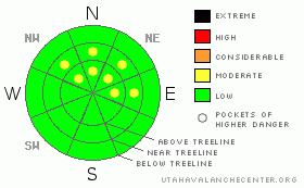
Danger Rose Tutorial
|
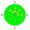
Pockets of Level 2 - Moderate avalanche danger may be found in the mountains of SE Utah above treeline on shady East through North through Northwest facing slopes. Upper elevation slopes above 11000 feet in the La Sals are the most suspect. Watch what the winds have been doing. Level 1 - LOW avalanche dangers can be expected elsewhere.
There have been scattered reports of good snow conditions in the La Sals, but poor coverage is the primary hazard for winter recreationists in the mountains of SE Utah at the moment. The snow is thin and ground hazards are pronounced. Be careful in the backcountry. |
|
|
CURRENT CONDITIONS |

|
Good Morning. It is Tuesday December 14th at 7:30 AM. Well there just isn't a lot to report from the mountains of SE Utah right now. We picked up a trace of snow over the weekend. La NIna seems to have us firmly in her grip and the snow that we do have has been sitting around for a long time. We have about 27" of snow at our Gold Basin Study Plot and only a foot of Snow at the Geyser Pass Snotel site. We remain at a miraculous 100% normal snowpack based on water weight but that figure tells a deceiving story. There is a lot of ice at the base of the snowpack contributing to this weight and there just isn't that much snow. The Camp Jackson Snotel site in the Abajos paints a more realistic picture with 9 inches of snow and 37% of normal snowpack on the season.
There remains slight potential for avalanches in the high country, but the primary hazard in mountains of SE Utah right now is the lack of coverage. Be careful out there folks.
The road to the Geyser Pass Trailhead has been plowed and is passable by a 2wd vehicle. Access to the east side of the La Sals and the Dark Canyon Trailhead has also been opened up.
The Cross Country ski trail into Gold Basin has been opened up. |
|
|
THREAT #1 |

|
| WHERE |
PROBABILITY |
SIZE |
TREND |
|
|
|
|
| |
|
|
Over the next
48 hours.
|
|
|
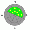
There just isn't a lot to report at the moment. We are so far out from our last storm cycle that there is very little load on our SE Utah snowpack. Despite the very weak nature of the snowpack at the moment, there is no load or overlying slab that could cause the buried weaknesses to fail. At most you can expect to find pockets Moderate (level 2) avalanche hazard at and above treeline where winds may have piled more snow in gully features or elsewhere that might collect snow. Unlikely but possible. A Low (level 1) avalanche danger can be expected on the sunnier aspects but don't expect a rewarding experience out on these thin, crusty slopes.
Snowpit test done so far this season indicate typically weak snowpack structures here in SE Utah and this is the case all through the Southwest south of I-70. You can see the results of our last snowpit tests here: 12/09/10 , 12/02/10. We are not alone. At least we live in Moab and not in Telluride.
Next storm is likely to bring us snow loads that will meet threshold values for widespread avalanching. It's hard to predict avalanche cycles with no new snow on the ground, but if we get more than 5 inches or so at 10000 feet and/or a half inch of water equivalent with this storm and any wind - likely in the SE Utah Mountains - we will see a significant avalanche cycle. |
|
|
THREAT #2 |

|
| WHERE |
PROBABILITY |
SIZE |
TREND |
|
|
|
|
| |
|
|
Over the next
24 hours.
|
|
|
Loose snow slides scraping the entire snowpack down to ground level are being reported from the San Juans. Full depth, unconsolidated faceted snow grains are responsible for this phenomena. Steep shady slopes tend a to be "facet gardens" where cold temperatures drive a metamorphic process that causes the snow to turn into unconsolidated sugar. This process is often responsible for weak layers in, or on top of, the snowpack that are subsequently buried by new snow, resulting in an unstable, avalanche producing snow situation. In this case, the entire snowpack had morphed into loose, unconsolidated snow that when triggered can't maintain it's hold on the steep mountainside. |
|
|
MOUNTAIN WEATHER |

|
Forecast for 10,000 feet:
Snow in the forecast for the next several days although forecast trajectory of the storm favors the north we should pick up some snow in SEUtah as well.
Today: Mostly cloudy, with a high near 42. South wind around 15 mph, with gusts as high as 25 mph. Tonight: Areas of blowing snow and a chance of snow after 11pm. Cloudy, with a low around 30. Breezy, with a southwest wind between 20 and 25 mph, with gusts as high as 40 mph. Chance of precipitation is 30%. Wednesday: Snow likely and areas of blowing snow before 11am, then snow and areas of blowing snow after 11am. High near 37. Breezy, with a west southwest wind between 20 and 25 mph, with gusts as high as 40 mph. Chance of precipitation is 80%. New snow accumulation of 2 to 4 inches possible. Wednesday Night: Snow. Low around 19. West northwest wind around 15 mph, with gusts as high as 30 mph. Chance of precipitation is 80%. New snow accumulation of 1 to 3 inches possible. Thursday: Snow likely, mainly before 11am. Mostly cloudy, with a high near 28. North northwest wind between 5 and 10 mph. Chance of precipitation is 70%. Thursday Night: A 20 percent chance of snow before 11pm. Mostly cloudy, with a low around 16. Friday: A 20 percent chance of snow. Partly sunny and breezy, with a high near 27. Friday Night: A chance of snow. Mostly cloudy and breezy, with a low around 17. Saturday: Snow likely. Cloudy, with a high near 30. |
|
|
GENERAL ANNOUNCEMENTS |
The LSAC will be offering 2 avalanche classes this year. Our yearly Level 1 class will be held January 28, 29 and 30 of this winter season. The level 1 class focuses on avalanche phenomena, recognition and management of terrain where you might encounter these beasts and basic rescue.
This season, if we can pick up 6 participants, we are also hoping to do a Level 2 class. Tenative dates for the class are February 24-27. It is a 4-day class reviewing the basics covered in level 1, then carrying the subject matter further, exploring snowpack formation, crystal analysis, climactic effects and advanced rescue.
Call 435-636-3363 and speak to Dave or Max for more information or to sign up for one of the classes.
Volunteers! Lower Utah Nordic Alliance (LUNA) groomer training is on December 18th. Learn how to groom and handle snowmachines. Cross-country and skate ski! Contribute to your community. Yeah. Call Kirsten at 260-0042 for more info or show up at the MARC at 7:30. |
|
|
This information does not apply to developed ski areas or highways where avalanche control is normally done. This advisory is from the U.S.D.A. Forest Service, which is solely responsible for its content. This advisory describes general avalanche conditions and local variations always occur. |
|
This advisory provided by the USDA Forest Service, in partnership with:
The Friends of the Utah Avalanche Center, Utah Division of State Parks and Recreation, Utah Division of Emergency Management, Salt Lake County, Salt Lake Unified Fire Authority and the friends of the La Sal Avalanche Center. See our Sponsors Page for a complete list. |
