BOTTOM LINE
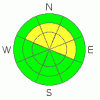
Danger by aspect and elevation on slopes approaching 35° or steeper.
(click HERE for tomorrow's danger rating)
|

Danger Rose Tutorial
|
Level 2 - Moderate avalanche dangers exist in mountains of SE Utah above treeline on shady East through North through Northwest facing slopes. Persistent, brittle wind slabs may be perched up high waiting for the unwary skier or high-marker. Level 1 - LOW avalanche dangers can be expected elsewhere.
Poor coverage is the primary hazard for winter recreationists in the mountains of SE Utah at the moment. The snow is thin and ground hazards are pronounced. Be careful in the backcountry. |
|
|
CURRENT CONDITIONS |

|
Good afternoon. It is Friday December 10th at 4:30 PM. Yesterday's grey skies and cloud did little to add to mountain snowpack here in SE Utah with the La Sals picking up only a trace of new snow. Tonight and Saturday's storm isn't expected to do much either, as most of the energy is forecast to pass to our north.
We have only 29 inches at our Gold Basin Study plot and the NRCS SNOTEL site above the Geyser Pass Trailhead shows only 12 inches. This accurately depicts the variability of our windblown snow and should also emphasize the lack of ground cover in the backcountry right now. While the potential for avalanches still exists in the high country, the primary hazard in mountains of SE Utah right now is the lack of coverage. Be careful out there folks.
The road to the Geyser Pass Trailhead has been plowed and is passable by a 2wd vehicle. Access to the east side of the La Sals and the Dark Canyon Trailhead has also been opened up.
The Grooming program has not officially started for the season but Max and I have packed the road into Gold Basin a couple of times and it is now in really good shape for skate skiing. |
|
|
RECENT ACTIVITY |

|
We haven't observed anything here in the La Sals but limited avi activity is still being reported from the San Juans with a nearly identical snowpack to what we have here in the La Sals. Very weak snowpack structures confirmed! |
|
|
THREAT #1 |

|
| WHERE |
PROBABILITY |
SIZE |
TREND |
|
|
|
|
| |
|
|
Over the next
48 hours.
|
|
|
Warm temperatures and a lack of new snow have combined to lessen both the avalanche danger in SE Utah and the recreational quality of our snowpack. Southeast through Southwest and West facing slopes are very thinly covered and crusted over. On the East through Northwest facing slopes, the shady sides, there are very weak snowpack structures. The snowpack is not active at the moment, but it will not take much of a snow load of storm snow, windblown snow or both. Moderate (level 2) avalanche hazard at and above treeline can be expected on shady side slopes above treeline. A Low (level 1) avalanche danger can be expected on the sunnier aspects but don't expect a rewarding experience out on these thin, crusty slopes.
Snowpit analysis indicates some seriously weak layers in the middle of the snowpack. Collapsing and Whoompfing observed last week and yesterday highlight these weak layers. The shears observed in our snowpits test produced blocks that shot out like a cash register opening. It is felt by the "smart guys" that when you get shears of this quality, you have serious avalanche issues or the potential for them. Right now, the avalanche danger is being kept down due to lack of snow. If and when we get significant precipitation, it's going to get wild in the mountains of SE Utah. You can see the results of our last snowpit tests here: 12/09/10 , 12/02/10. In the event of a missed weather forecast and more-than-forecast amounts of new snow, expect a corresponding rise in the avalanche danger. It won't take much wind or new snow. |
|
|
MOUNTAIN WEATHER |

|
Forecast for 10,000 feet:
Next storm cycle favors the northern parts of Utah and Colorado. Expect warm and windy conditions here in SEUtah. No accumulation in our zone forecast. Chance of snow again mid-week.
This Afternoon: A 30 percent chance of snow. Mostly cloudy, with a high near 37. West wind around 15 mph, with gusts as high as 35 mph. Tonight: A 40 percent chance of snow. Mostly cloudy, with a low around 20. West wind between 10 and 15 mph, with gusts as high as 35 mph. Saturday: A 30 percent chance of snow before 11am. Partly sunny, with a high near 32. West northwest wind between 5 and 15 mph. Saturday Night: A 20 percent chance of snow after 11pm. Mostly cloudy, with a low around 21. Northwest wind 5 to 10 mph becoming east. Sunday: A 20 percent chance of snow. Partly sunny, with a high near 38. South southeast wind 5 to 15 mph becoming north northwest. Sunday Night: Partly cloudy, with a low around 22. Monday: Sunny, with a high near 45. Monday Night: Mostly clear, with a low around 23. Tuesday: Mostly sunny, with a high near 43. Tuesday Night: Mostly cloudy, with a low around 23. Wednesday: A chance of snow. Mostly cloudy, with a high near 35. |
|
|
GENERAL ANNOUNCEMENTS |
The LSAC will be offering 2 avalanche classes this year. Our yearly Level 1 class will be held January 28, 29 and 30 of this winter season. The level 1 class focuses on avalanche phenomena, recognition and management of terrain where you might encounter these beasts and basic rescue.
This season, if we can pick up 6 participants, we are also hoping to do a Level 2 class. Tenative dates for the class are February 24-27. It is a 4-day class reviewing the basics covered in level 1, then carrying the subject matter further, exploring snowpack formation, crystal analysis, climactic effects and advanced rescue.
Call 435-636-3363 and speak to Dave or Max for more information or to sign up for one of the classes.
Volunteers! Lower Utah Nordic Alliance (LUNA) groomer training is on December 18th. Learn how to groom and handle snowmachines. Cross-country and skate ski! Contribute to your community. Yeah. Call Kirsten at 260-0042 for more info or show up at the MARC at 7:30. |
|
|
This information does not apply to developed ski areas or highways where avalanche control is normally done. This advisory is from the U.S.D.A. Forest Service, which is solely responsible for its content. This advisory describes general avalanche conditions and local variations always occur. |
|
This advisory provided by the USDA Forest Service, in partnership with:
The Friends of the Utah Avalanche Center, Utah Division of State Parks and Recreation, Utah Division of Emergency Management, Salt Lake County, Salt Lake Unified Fire Authority and the friends of the La Sal Avalanche Center. See our Sponsors Page for a complete list. |
