BOTTOM LINE
Danger by aspect and elevation on slopes approaching 35° or steeper.
(click HERE for tomorrow's danger rating)
|
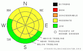
Danger Rose Tutorial
|
Good powder, bad coverage. Unless you know the area you are skiing or riding in has a smooth undersurface, use extreme caution. Roads are in good shape for cross-country skiing and the best bet at the moment for skiing and snow machines.
Level 2 - Moderate avalanche dangers exist in mountains of SE Utah. |
|
|
CURRENT CONDITIONS |

|
Good Morning. It's Tuesday December 7th at 7:30 AM. Well yesterday's storm didn't produce much and we picked up another inch or two depending on where you're standing in the La Sals and even less than that in the Abajos. We have about 30 inches at our Gold Basin Study Plot and the SNOTEL site shows only 14 inches, Highlighting the effect of SW winds in our "spatially variable" snowpack
Collapsing and "whoompfing" continue to indicate unstable snow structures and the potential for avalanches in areas where the snow is deep enough to produce a slide. Snowpit tests last week showed some very weak layers in the mid-depth snowpack.
The road to the Geyser Pass Trailhead has been plowed by San Juan County. Thanks guys.
The road from the Geyser Pass Trailhead into Gold Basin has also been groomed by the roller, but after yesterday's dusting expect "powder skating" if you try. |
|
|
RECENT ACTIVITY |

|
Nothing noted but limited observations thus far. Very weak snowpack structures confirmed! |
|
|
THREAT #1 |

|
| WHERE |
PROBABILITY |
SIZE |
TREND |
|
|
|
|
| |
|
|
Over the next
48 hours.
|
|
|
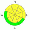
Moderate (level 2) avalanche hazard at and above treeline can be expected at a minimum. Snowpit analysis indicates some seriously weak layers in the middle of the snowpack. Collapsing and Whoompfing observed last week highlight these weak layers. The shears observed in our snowpits test produced blocks that shot out like a cash register opening. It is felt by the "smart guys" that when you get shears of this quality, you have serious avalanche issues. Right now I think the avalanche danger is being kept down due to lack of snow. If and when we get significant precipitation, it's going to get wild in the mountains of SE Utah. |
|
|
THREAT #2 |

|
| WHERE |
PROBABILITY |
SIZE |
TREND |
|
|
|
|
| |
|
|
Over the next
48 hours.
|
|
|
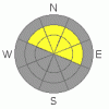
Pockets of wind slab are possible at higher elevations where it may have snowed more than we measured at our study plots and been drifted by winds. |
|
|
MOUNTAIN WEATHER |

|
Looks like a pretty nice week of high pressure for SE Utah with a chance for snow later in the week.
Today: Mostly sunny, with a high near 35. Calm wind becoming north around 5 mph. Tonight: Mostly clear, with a low around 21. North wind around 5 mph becoming southeast. Wednesday: Mostly sunny, with a high near 37. South wind around 5 mph. Wednesday Night: Mostly cloudy, with a low around 26. South southeast wind around 5 mph. Thursday: Partly sunny, with a high near 38. Calm wind becoming west around 5 mph. Thursday Night: A 20 percent chance of snow. Mostly cloudy, with a low around 26. Friday: Partly sunny, with a high near 32. Friday Night: A chance of snow. Mostly cloudy and blustery, with a low around 21. Saturday: A slight chance of snow. Partly sunny, with a high near 28. |
|
|
GENERAL ANNOUNCEMENTS |
The LSAC will be offering 2 avalanche classes this year. Our yearly Level 1 class will be held January 28, 29 and 30 of this winter season. The level 1 class focuses on avalanche phenomena, recognition and management of terrain where you might encounter these beasts and basic rescue.
This season, if we can pick up 6 participants, we are also hoping to do a Level 2 class. Tenative dates for the class are February 24-27. It is a 4-day class reviewing the basics covered in level 1, then carrying the subject matter further, exploring snowpack formation, crystal analysis, climactic effects and advanced rescue.
Call 435-636-3363 and speak to Dave or Max for more information or to sign up for one of the classes.
Volunteers! Lower Utah Nordic Alliance (LUNA) groomer training is on December 18th. Learn how to groom and handle snowmachines. Cross-country and skate ski! Contribute to your community. Yeah. Call Kirsten at 260-0042 for more info or show up at the MARC at 7:30. |
|
|
This information does not apply to developed ski areas or highways where avalanche control is normally done. This advisory is from the U.S.D.A. Forest Service, which is solely responsible for its content. This advisory describes general avalanche conditions and local variations always occur. |
|
This advisory provided by the USDA Forest Service, in partnership with:
The Friends of the Utah Avalanche Center, Utah Division of State Parks and Recreation, Utah Division of Emergency Management, Salt Lake County, Salt Lake Unified Fire Authority and the friends of the La Sal Avalanche Center. See our Sponsors Page for a complete list. |
