Moab Avalanche Advisory

Forecaster: Dave Medara

SPECIAL ANNOUNCEMENT

The La Sal Avalanche Center will be closing it's doors on April 1st. This will be our final forecast. It has been a great winter here in SE Utah and we're finishing the season at 140-150 percent of normal. Skiing will be good in the high country well into June this year so pack your skiis when you load up the rig and head for Southern Utah this spring. If spring ever get here that is....Adios from Dave and Max. We'll see you next winter.


BOTTOM LINE

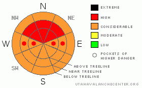
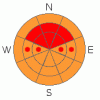
Danger by aspect and elevation on slopes approaching 35° or steeper.
(click HERE for tomorrow's danger rating)


Danger Rose Tutorial

Click here to see the newly revised North American Avalanche Danger Scale.

Avalanche Dangers have risen to HIGH on steep E, NE, N, and NW facing terrain at and above treeline. Expect to find a CONSIDERABLE avalanche danger on other slopes. Remember, CONSIDERABLE danger means Human Triggered avalanches are likely, and HIGH means go bowling or stay completely away from steep mountain terrain. We've reached that critical inch of water at all of our mountain data collection sites and continued snowfall and wind are forecast for mountain regions in SE Utah.


CURRENT CONDITIONS

Snow is falling fast and furious this morning int he La Sal and Abajo Mountains. We've picked up 7 inches at the La Sal Snotel site containing 1.1 inches of water, 11 inches according to the Gold Basin Sonic snow depth stake (no water content yet) and 7 inches containing 1.0 inches of water at Camp Jackson in the La Sals. Spring corn conditions continue to be delayed SE Utah. Winds of the last 2 days have been the headline item with several gusts into the 60's being reported as late as 3AM this morning. Winds have kept most people grounded and wind damage to the snow surface and dirt deposits will have further pushed back formation of spring corn snow. This new snow will freshen things up on north facing slopes but expect a corresponding rise in the avalanche danger to go with the new snow.

Roads to Mountain Trailheads will not be plowed this morning so expect challenging conditions with drifts from the high winds.

Grooming has been buried yet again on the La Sal Nordic Track. No word on the next grooming mission. Kirsten is looking for volunteers!


RECENT ACTIVITY

Wet activity before the windstorm began a couple of days ago.


THREAT #1

WHERE PROBABILITY SIZE TREND
      Over the next 48 hours.

The new snow falling across SE Utah is our primary avalanche concern right now. The rapid pace it is falling at and the strong southerly winds will enhance slab formation on downwind, or lee, slopes creating dangerous avalanche conditions on East, through Northeast, through Northwest facing slopes at and above treeline. We are rating the Avalanche Danger HIGH on these shady side aspects where wind deposition of new snow is occurring. We also expect the avalanche danger to rise, spreading the HIGH rating to other aspects and elevations. We are just starting out with this storm and another 6-14 inches are expected of the next 24 hours. HEADS UP backcountry travelers, winter is going out with a solid bang!


MOUNTAIN WEATHER

National Weather Service Forecast for 10,000 Ft. :

Today:

Snow showers and areas of blowing snow. Some thunder is also possible. High near 23. Windy, with a west

southwest

wind between 20 and 30 mph, with gusts as high as 50 mph. Chance of precipitation is 100%. Total daytime snow accumulation of 3 to 7 inches possible.

Tonight:

Snow showers and areas of blowing snow before midnight, then snow showers likely after midnight. Low around 10. Northwest wind between 10 and 15 mph, with gusts as high as 35 mph. Chance of precipitation is 80%. New snow accumulation of 3 to 7 inches possible.

Friday:

A 40 percent chance of snow showers. Mostly cloudy, with a high near 29. Northwest wind between 5 and 10 mph.

Friday Night:

Mostly cloudy, with a low around 15.

Southwest

wind between 5 and 15 mph.

Saturday:

A 20 percent chance of snow. Mostly cloudy, with a high near 39. South southeast wind around 15 mph becoming west

southwest

.

Saturday Night:

Mostly cloudy, with a low around 21.

Sunday:

Mostly cloudy, with a high near 42.

Sunday Night:

Mostly cloudy, with a low around 21.

Monday:

A chance of snow. Mostly cloudy, with a high near 37.


GENERAL ANNOUNCEMENTS

We would like to thank the hard working volunteers at the Friends of the La Sal Avalanche Center. Without their help the center would not meet it's funding or staffing requirements. Thanks all! If you would like more information about donating to the Friends or simply helping out, click here..

This advisory will expire in 48 hours.

We cannot receive messages on our 259-SNOW line. If you would like to leave us an observation or a message, you my reach us at 435-636-3363.


This information does not apply to developed ski areas or highways where avalanche control is normally done.  This advisory is from the U.S.D.A. Forest Service, which is solely responsible for its content. This advisory describes general avalanche conditions and local variations always occur.


This advisory provided by the USDA Forest Service, in partnership with:

The Friends of the Utah Avalanche Center, Utah Division of State Parks and Recreation, Utah Division of Emergency Management, Salt Lake County, Salt Lake Unified Fire Authority and the friends of the La Sal Avalanche Center. See our Sponsors Page for a complete list.