Moab Avalanche Advisory

Forecaster: Dave Medara

SPECIAL ANNOUNCEMENT

The La Sal Avalanche Center will be closing it's doors on April 1st. It has been a great winter here in SE Utah and we're finishing the season at 140-150 percent of normal. Skiing will be good in the high country well into June this year so pack your skiis when you load up the rig and head for Southern Utah this spring. If spring ever get here that is....Adios from Dave and Max. We'll see you next winter!


BOTTOM LINE

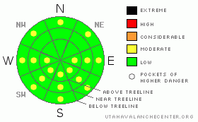
Danger by aspect and elevation on slopes approaching 35° or steeper.
(click HERE for tomorrow's danger rating)


Danger Rose Tutorial

Click here to see the newly revised North American Avalanche Danger Scale.

LOW avalanche danger will rise to MODERATE on sunny side slopes today with daytime heating. Lower elevation North facing slopes are also being affected by warming and may become reactive with the heat of the day today as well. Spring Corn skiing is not well developed yet and due south will be your best bet for decent conditions today, provided you don't get beaten back by winds up to 70 MPH forecast for today at ridgetop elevations. It will be a short window, if there is one at all as last night's freeze was not very solid.


CURRENT CONDITIONS

Winds have been up all night and are expected to climb to even higher speeds today in advance of yet another storm that is heading into SE Utah. Southerly winds have averaged in the low 30's overnight with gusts in the high 40's. Average winds are expected to climb into the 40's today with gusts to 70 MPH at ridgetop elevations. Last nights' freeze was less than solid, with temperatures reaching freezing only at about 10,500 feet and above. Even if you manage to claw your way up a peak for some spring skiing today in the wind, your corn snow run might not be that satisfying. Overnight lows were 39 degrees at the La Sal Snotel, 28.5 degrees at the Pre-Laurel Peak wx-station at 11, 700 FT and 35 degrees at the Gold Basin wx-station at 10,000 ft.

Roads to Mountain Trailheads haven't been cleared since the last storm but are passable. 4wd and chains recommended.

Grooming has been buried yet again on the La Sal Nordic Track. No word on the next grooming mission.


RECENT ACTIVITY

Wet loose activity with daytime warming over the last couple of days.


THREAT #1

WHERE PROBABILITY SIZE TREND
      Over the next 24 hours.

Our primary avalanche hazard right now is wet slide. Loose snow and slab avalanches are possible with daytime heating. Expect the danger to start out LOW and rise to MODERATE with warming today. Temperatures are forecast to rise into the mid 50's today, so even if the sun doesn't shine that brightly, wet slides are likely. Temperatures are now getting warm enough that lower elevation North facing slopes that did not freeze last night may want to get in on the action as well.


MOUNTAIN WEATHER

National Weather Service Forecast for 10,000 Ft. :

Today:

Partly sunny, with a high near 56. Windy, with a south

southwest

wind between 25 and 35 mph, with gusts as high as at 70 mph at ridgetop elevations

Tonight:

Mostly cloudy, with a low around 33. Very windy, with a

southwest

wind between 30 and 40 mph, with gusts as high as 60 mph.

Wednesday:

Snow showers likely, mainly after 3pm. Cloudy, with a high near 41. Windy, with a south

southwest

wind between 30 and 35 mph, with gusts as high as 45 mph. Chance of precipitation is 60%. New snow accumulation of 1 to 2 inches possible.

Wednesday Night:

Snow. Low around 25. Windy, with a

southwest

wind between 25 and 35 mph, with gusts as high as 55 mph. Chance of precipitation is 90%. New snow accumulation of 2 to 4 inches possible.

Thursday:

Snow. High near 26.

Southwest

wind between 10 and 15 mph. Chance of precipitation is 80%.

Thursday Night:

A 50 percent chance of snow. Cloudy, with a low around 7.

Friday:

A 30 percent chance of snow. Mostly cloudy, with a high near 25.


GENERAL ANNOUNCEMENTS

We would like to thank the hard working volunteers at the Friends of the La Sal Avalanche Center. Without their help the center would not meet it's funding or staffing requirements. Thanks all! If you would like more information about donating to the Friends or simply helping out, click here..

This advisory will expire in 48 hours.

We cannot receive messages on our 259-SNOW line. If you would like to leave us an observation or a message, you my reach us at 435-636-3363.


This information does not apply to developed ski areas or highways where avalanche control is normally done.  This advisory is from the U.S.D.A. Forest Service, which is solely responsible for its content. This advisory describes general avalanche conditions and local variations always occur.


This advisory provided by the USDA Forest Service, in partnership with:

The Friends of the Utah Avalanche Center, Utah Division of State Parks and Recreation, Utah Division of Emergency Management, Salt Lake County, Salt Lake Unified Fire Authority and the friends of the La Sal Avalanche Center. See our Sponsors Page for a complete list.