Moab Avalanche Advisory

Forecaster: Dave Medara

BOTTOM LINE

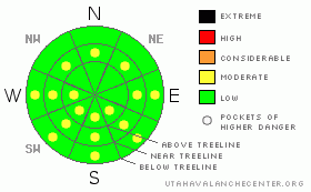
Danger by aspect and elevation on slopes approaching 35° or steeper.
(click HERE for tomorrow's danger rating)


Danger Rose Tutorial

Click here to see the newly revised North American Avalanche Danger Scale.

Generally LOW avalanche danger exist in the mountains of SE Utah at this time. Dangers will rise on sunny side slopes with daytime heating over the next two days. Transitional period in SE Utah right now with too much new snow for corn skiing and too much sun for good powder skiing except high north facing.


CURRENT CONDITIONS

The Mountains of SE Utah remain in a transition period right now with limited powder skiing because of sun effects, and immature spring skiing because of new snow. We rec'd 3.5" of new snow Tuesday and Tuesday night and strong winds yesterday morning blew a lot of that snow onto sunny side slopes further delaying the spring corn process. Temperatures in the high 30's yesterday would be a good start to the spring skiing process but another storm progged to hit SE Utah Late Friday will derail spring skiing for the weekend. Good conditions can still be found on shady side slopes but don't stray too far from NORTH facing or sun effects will become more pronounced. After the Fri/Sat storm, high pressure moving into the region should set us up for some good spring conditions. It promises to be a memorable spring season here in SE Utah with snow totals still in the 140-150 % range. We have 76" of snow on the ground at our Gold Basin study plot.

Roads to Mountain Trailheads haven't been cleared since the last storm. Roads are passable but there are some big drifts so a high clearance vehicle is recommended.

Matt Hebbard rolled the La Sal Nordic track again yesterday. Go Matt! I followed up with the other groomer and put down classic 2-track into Gold Basin. Should be good today.


RECENT ACTIVITY

Wet slide activity noted on sunny side slopes from warm temps Sunday and Wednesday.


THREAT #1

WHERE PROBABILITY SIZE TREND
No trend identified.

Expect the generally LOW avalanche danger to rise to MODERATE on sunny side slopes with daytime heating today and possibly tomorrow before the storm. In areas with deeper deposition (likely East and SE and SW facing slopes from North winds) the sluffs could entrain a fairly deep pile of debris at the bottom of a steep slope. If you are in one of these gougers, it won't feel moderate.


THREAT #2

WHERE PROBABILITY SIZE TREND
      Over the next ?? hours.

Persistent weak layers may still exist in the form of buried SURFACE HOAR layers. The primary layer deposited on Feb. 1 is buried 3.5 - 5 feet deep now and is unlikely to be triggered by the weight of a skier, however thinner snowpack areas and likely trigger points around rocks, cliff and convexities should still be treated with respect on slopes steeper than 35 degrees.


MOUNTAIN WEATHER

National Weather Service Forecast for 10,000 Ft. :

Today:

Mostly sunny, with a high near 41. South wind between 10 and 15 mph.

Tonight:

Cloudy, with a low around 23. South

southwest

wind between 5 and 15 mph.

Friday:

Snow, mainly after noon. High near 30. Calm wind becoming northwest between 5 and 10 mph. Chance of precipitation is 80%. New snow accumulation of 1 to 3 inches possible.

Friday Night:

Snow. Low around 14. Northwest wind between 5 and 10 mph. Chance of precipitation is 80%. New snow accumulation of 2 to 4 inches possible.

Saturday:

A 30 percent chance of snow before noon. Partly cloudy, with a high near 30. North northwest wind between 5 and 10 mph.

Saturday Night:

Mostly clear, with a low around 20.

Sunday:

Sunny, with a high near 41.

Sunday Night:

Mostly clear, with a low around 24.

Monday:

Sunny, with a high near 49.

Monday Night:

Partly cloudy, with a low around 26.

Tuesday:

Mostly sunny, with a high near 46.


GENERAL ANNOUNCEMENTS

We would like to thank the hard working volunteers at the Friends of the La Sal Avalanche Center. Without their help the center would not meet it's funding or staffing requirements. Thanks all! If you would like more information about donating to the Friends or simply helping out, click here..

This advisory will expire in 48 hours.

We cannot receive messages on our 259-SNOW line. If you would like to leave us an observation or a message, you my reach us at 435-636-3363.


This information does not apply to developed ski areas or highways where avalanche control is normally done.  This advisory is from the U.S.D.A. Forest Service, which is solely responsible for its content. This advisory describes general avalanche conditions and local variations always occur.


This advisory provided by the USDA Forest Service, in partnership with:

The Friends of the Utah Avalanche Center, Utah Division of State Parks and Recreation, Utah Division of Emergency Management, Salt Lake County, Salt Lake Unified Fire Authority and the friends of the La Sal Avalanche Center. See our Sponsors Page for a complete list.