Moab Avalanche Advisory

Forecaster: Dave Medara

BOTTOM LINE

Danger by aspect and elevation on slopes approaching 35° or steeper.
(click HERE for tomorrow's danger rating)


Danger Rose Tutorial

Click here to see the newly revised North American Avalanche Danger Scale.

Sunny weather takes a brief break as a small storm moves across SE Utah tomorrow and tomorrow night. Avalanche Dangers are generally LOW with wind loading up high as the storm progresses creating possible pockets of MODERATE danger near and above treeline.

We are very close to a corn snow cycle in SE Utah but this storm will delay it a bit.


CURRENT CONDITIONS

Once again, as we are on the verge of a corn cycle after 3 days of sunny weather, Mother Nature plans on throwing a wrench into the works and bringing anther storm to SE Utah. This should only be a minor detour from our march towards spring skiing as accumulations of new snow shouldn't amount to much. The beautiful sunny weather we've been experiencing will go back into hiding for a day but spring skiing should be back on track Wed. or Thurs. Good skiing and riding conditions are still being reported on north facing slopes in the meantime, but venture off that aspect at your own peril...

Roads to Mountain Trailheads haven't been cleared since the last storm but are in good shape. Packed out snow above 8500' is slippery so be prepared!

Matt Hebbard rolled the La Sal Nordic track again today. Go Matt! Our second grooming machine has been fixed so we should finish out the season with some excellent cross-country skiing conditions.


RECENT ACTIVITY

Wet slide activity noted on sunny side slopes from warm temps yesterday (Sunday). Nothing big.


THREAT #1

WHERE PROBABILITY SIZE TREND
      Over the next 48 hours.

We are finally down to a LOW avalanche danger for one of the first forecasts in recent memory. With low temps and hardly any precipitation forecast for tomorrow and tomorrow night I don't see a big rise in the Avalanche Danger other than localized wind slabs above treeline, which may lead to pockets of MODERATE avalanche danger in downwind locations.


THREAT #2

WHERE PROBABILITY SIZE TREND
      Over the next ?? hours.

Persistent weak layers may still exist in the form of buried SURFACE HOAR layers. If you find yourself on a cross-loaded slope with a shady aspect at mid-elevations, the risk of knocking out a deep slab still exists. We did have a close call on a deeply buried weak layer the weekend before last. Localized winds can be different, and a loaded, steep NE-N or NW facing slopes is a potential problem still.


MOUNTAIN WEATHER

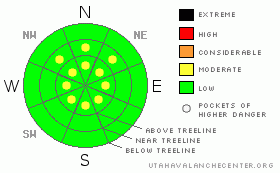
National Weather Service Forecast for 10,000 Ft. :

Tonight:

A 20 percent chance of snow after midnight. Mostly cloudy, with a low around 23. Southwest wind between 5 and 10 mph.

Tuesday:

Snow. High near 36. Calm wind becoming north northwest around 5 mph. Chance of precipitation is 80%. New snow accumulation of 1 to 2 inches possible.

Tuesday Night:

Snow likely. Cloudy, with a low around 17. Northeast wind between 5 and 10 mph. Chance of precipitation is 70%. New snow accumulation of 1 to 2 inches possible.

Wednesday:

A 30 percent chance of snow. Mostly cloudy, with a high near 39. North northeast wind between 5 and 10 mph.

Wednesday Night:

Partly cloudy, with a low around 19.

Thursday:

Mostly sunny, with a high near 42.

Thursday Night:

Partly cloudy, with a low around 24.

Friday:

A chance of snow showers. Mostly cloudy, with a high near 42.

Friday Night:

A chance of snow. Mostly cloudy, with a low around 24.


GENERAL ANNOUNCEMENTS

We would like to thank the hard working volunteers at the Friends of the La Sal Avalanche Center. Without their help the center would not meet it's funding or staffing requirements. Thanks all! If you would like more information about donating to the Friends or simply helping out, click here..

This advisory will expire in 48 hours.

We cannot receive messages on our 259-SNOW line. If you would like to leave us an observation or a message, you my reach us at 435-636-3363.


This information does not apply to developed ski areas or highways where avalanche control is normally done.  This advisory is from the U.S.D.A. Forest Service, which is solely responsible for its content. This advisory describes general avalanche conditions and local variations always occur.


This advisory provided by the USDA Forest Service, in partnership with:

The Friends of the Utah Avalanche Center, Utah Division of State Parks and Recreation, Utah Division of Emergency Management, Salt Lake County, Salt Lake Unified Fire Authority and the friends of the La Sal Avalanche Center. See our Sponsors Page for a complete list.