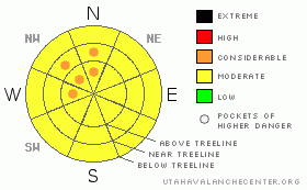
BOTTOM LINE
Danger by aspect and elevation on slopes approaching 35° or steeper.
(click HERE for tomorrow's danger rating)
|
Danger Rose Tutorial
|
Click here to see the newly revised North American Avalanche Danger Scale.
In the Mountains of SE Utah a MODERATE avalanche danger can be found in most areas but we are still on the lookout for more dangerous pockets of CONSIDERABLE danger on mid and upper elevation N-NW-N facing slopes that have been loaded by winds from the south and east. They blew pretty good and thick wind slabs on west facing slopes have been reported. Wet slides will be possible on sunny side slopes after the daily bake-off now that sunny skies have returned to SE Utah so plan accordingly. if you are out corn skiing, get in and out early. |
|
|
CURRENT CONDITIONS |

|
After all the storm we've been experiencing over the last few weeks the beautiful spring weather we are experiencing in Moab at the moment is a welcome change. With good powder in the mountains and a spring corn snow cycle just around the corner, who could ask for more? With today's high of 45 and a couple more days of sunny weather forecast spring skiing may finally get a foothold in S. Utah. Recapping last weekend's storm we finished with 6 inches in Gold Basin and a similar amount in the Abajos. Winds were up so expect some wind funk up above treeline.
Roads in to the La Sal and Abajo Mountains Trailheads have been cleared. Thank you San Juan County.
Matt Hebbard (again) went up and groomed the entire La Sal Nordic track. All 12 miles. Enjoy.We are having Matt Knighted. |
|
|
RECENT ACTIVITY |

|
Skier release on Horsehead Peak above Buckboard Flat in the Abajos on Saturday. Persistent weak layers we've been on about since early Feb. finally produced. Take a look here.
Natural release on the North Face of Tukunikuvatz overnight Sunday night. Observed Yesterday. Pretty good Class 2. Photo Here.
Thanks to Pat Lambrose for the photos.
In Addition, lots of wet point release activity has been noted on sunny side slopes. |
|
|
THREAT #1 |

|
| WHERE |
PROBABILITY |
SIZE |
TREND |

|
|
|
|
| |
|
|
Over the next
48 hours.
|
|
|
Winds slabs from the East and south winds are still possible on mid and upper elevation slopes that may have been loaded - or cross-loaded. Despite only having had 12 inches of new snow since last Wed. night, we've had a couple of pretty good sized avalanches. The one on Tukunikuvatz (described above) illustrates the east wind's capability for loading west facing slopes. The slide initiated on a roll with a strong westerly component to it. While warm temperatures and time are lessening the danger, we have not made the transition to green light conditions. Slabby, thick conditions were reported on open slopes near treeline and above treeline yesterday. We're calling the avalanche danger MODERATEwith pockets of CONSIDERABLEon slopes down wind of the south and east winds we've had. These pockets will more likely be found at higher elevation and in areas where today's strong sun didn't bake the new snow forming a surface crust. |
|
|
THREAT #2 |

|
| WHERE |
PROBABILITY |
SIZE |
TREND |
|
|
|
|
| |
|
|
Over the next
48 hours.
|
|
|
As evidenced by slide in the Abajos that ran up to 5 feet deep and about 600 feet wide, deep, persistent weaknesses in our "old" snow are still a problem. In this particular case, the slope was mid-elevation, ENE facing and averaged 35 to 40 degrees in steepness. This slope, fits, to a tee, the areas we have been describing where avalanches of this type might occur. Buried Surface Hoar or Depth Hoar may have been the weak layer this large avalanche failed on it is not know precisely. Either way, we still have to take into account the possibility of layers like these. These deep layers may become active again with the weight of new storm snow and the right trigger, likely in a shallower snowpack area, as was the case with the Horsehead Peak slide. |
|
|
THREAT #3 |

|
| WHERE |
PROBABILITY |
SIZE |
TREND |

|
|
|
|
| |
|
|
Over the next
24
hours.
|
|
|
Wet slides. Watch 'em. They like to come out in the afternoon when sunny side slopes get wet and sloppy. If you find yourself out on sunny side slopes too late in the afternoon, get out of there! These are the easiest avalanche type to predict because we know when steep slopes become wet, unfrozen, unconsolidated and really warm, they're gonna avalanche. This will take place later in the day, when the sun has been baking a slope for an extended amount of time, or during periods of higher than normal temperatures. Early in, early out for corn folks! |
|
|
MOUNTAIN WEATHER |

|
National Weather Service Forecast for 10,000 Ft. :
Tonight:
Clear, with a low around 21. East wind around 5 mph.
Wednesday:
Sunny, with a high near 37. East wind around 5 mph becoming calm.
Wednesday Night:
Mostly clear, with a low around 27. Calm wind becoming southeast around 5 mph.
Thursday:
Partly sunny, with a high near 49. Southeast wind around 5 mph becoming
southwest
Thursday Night:
Snow likely, mainly after midnight. Cloudy, with a low around 23.
Southwest
wind between 5 and 10 mph becoming calm. Winds could gust as high as 25 mph. Chance of precipitation is 60%.
Friday:
Snow. High near 27. Chance of precipitation is 80%.
Friday Night:
A 50 percent chance of snow showers. Cloudy, with a low around 8.
Saturday:
A slight chance of snow showers. Mostly cloudy, with a high near 25. |
|
|
GENERAL ANNOUNCEMENTS |
We would like to thank the hard working volunteers at the Friends of the La Sal Avalanche Center. Without their help the center would not meet it's funding or staffing requirements. Thanks all! If you would like more information about donating to the Friends or simply helping out, click here..
This advisory will expire in 48 hours.
We cannot receive messages on our 259-SNOW line. If you would like to leave us an observation or a message, you my reach us at 435-636-3363. |
|
|
This information does not apply to developed ski areas or highways where avalanche control is normally done. This advisory is from the U.S.D.A. Forest Service, which is solely responsible for its content. This advisory describes general avalanche conditions and local variations always occur. |
|
This advisory provided by the USDA Forest Service, in partnership with:
The Friends of the Utah Avalanche Center, Utah Division of State Parks and Recreation, Utah Division of Emergency Management, Salt Lake County, Salt Lake Unified Fire Authority and the friends of the La Sal Avalanche Center. See our Sponsors Page for a complete list. |
