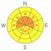
BOTTOM LINE
Danger by aspect and elevation on slopes approaching 35° or steeper.
(click HERE for tomorrow's danger rating)
|

Danger Rose Tutorial
|
Click here to see the newly revised North American Avalanche Danger Scale.
CONSIDERABLE(3) avalanche dangers can be expected in the Mountains of SE Utah with new snow and high winds. Watch warming on steep sunny side slopes when the sun comes out today or tomorrow as well. |
|
|
CURRENT CONDITIONS |

|
4 inches of new snow has been measured at all available precipitations site in the SE Utah Mountains in a rare show of solidarity. Winds have backed off this morning after roaring through like a freight train last night. Sheltered N. facing slopes will have great snow on them. Any slopes without a strong northerly component in them have been crusted over by the sun before this last storm and conditions will reflect that. Trailhead temps this morning are in the Mid 20's with winds forecast to come around to light WNW, although we remain is a very moist easterly flow at the moment with rain at valley elevations. |
|
|
RECENT ACTIVITY |

|
nothing yet. |
|
|
THREAT #1 |

|
| WHERE |
PROBABILITY |
SIZE |
TREND |
|
|
|
|
| |
|
|
Over the next
48 hours.
|
|
|
With last night's strong winds from the south, wind loading and cross-loading are a very strong possibility at upper elevations. We have bumped the avalanche danger rating to CONSIDERABLE (3) with this new snow and wind. In deeper deposition areas it may also be possible to trigger slides on deeper buried weaknesses that have been plaguing us this winter. |
|
|
THREAT #2 |

|
| WHERE |
PROBABILITY |
SIZE |
TREND |

|
|
|
|
| |
|
|
Over the next
48 hours.
|
|
|
Persistent slabs on surface hoar layers in the snowpack are still a potential problem. 4-5 feet down is the Feb. 1st surface hoar layer with large 2-4 mm feathery crystals still intact. It's reactivity in snow pit tests is has been very long lasting. While unlikely to be triggered by the weight of a skier buried at this depth, the combination of new snow drifting and this layer could bring out a big surprise. Surface Hoar from Mar. 4th has also been noted 18-20 inches deep at this point. We haven't seen the reactivity on the Mar. 4th layer displayed by the more deeply buried layer, but it is worth keeping and eye on as it is much more likely to be triggered by the weight of a skier or rider. It will be interesting to see if this layer will be activated again by the weight of new snow if the current forecast holds true.
|
|
|
THREAT #3 |

|
| WHERE |
PROBABILITY |
SIZE |
TREND |

|
|
|
|
| |
|
|
Over the next
24
hours.
|
|
|
Inevitably, this storm will end and when it does the solar radiation increase with strong spring sun will likely bring down wet slides on sunny side slopes steeper than 35 degrees. Please be aware of this possibility.
|
|
|
MOUNTAIN WEATHER |

|
National Weather Service Forecast for 10,000 Ft. :
Wild card Easterly flow with moisture!
Today: Snow showers. Some thunder is also possible. High near 30. West northwest wind between 5 and 10 mph. Chance of precipitation is 100%. Total daytime snow accumulation of 3 to 5 inches possible. Tonight: A 20 percent chance of snow showers before midnight. Mostly cloudy, with a low around 20. North wind between 5 and 10 mph. Monday: Mostly sunny, with a high near 35. East northeast wind 5 to 10 mph becoming west. Monday Night: Mostly clear, with a low around 22. North northwest wind between 5 and 10 mph. Tuesday: Sunny, with a high near 41. Calm wind becoming north northwest around 5 mph. Tuesday Night: Mostly clear, with a low around 24. Wednesday: Sunny, with a high near 42. |
|
|
GENERAL ANNOUNCEMENTS |
We would like to thank the hard working volunteers at the Friends of the La Sal Avalanche Center. Without their help the center would not meet it's funding or staffing requirements. Thanks all! If you would like more information about donating to the Friends or simply helping out, click here..
This advisory will expire in 48 hours.
We cannot receive messages on our 259-SNOW line. If you would like to leave us an observation or a message, you my reach us at 435-636-3363.
|
|
|
This information does not apply to developed ski areas or highways where avalanche control is normally done. This advisory is from the U.S.D.A. Forest Service, which is solely responsible for its content. This advisory describes general avalanche conditions and local variations always occur. |
|
This advisory provided by the USDA Forest Service, in partnership with:
The Friends of the Utah Avalanche Center, Utah Division of State Parks and Recreation, Utah Division of Emergency Management, Salt Lake County, Salt Lake Unified Fire Authority and the friends of the La Sal Avalanche Center. See our Sponsors Page for a complete list. |
