Moab Avalanche Advisory

Forecaster: Dave Medara

BOTTOM LINE

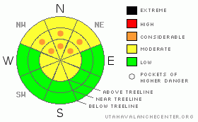
Danger by aspect and elevation on slopes approaching 35° or steeper.
(click HERE for tomorrow's danger rating)


Danger Rose Tutorial

Click here to see the newly revised North American Avalanche Danger Scale.

Avalanche Danger in the Mountains of SE Utah has dropped MODERATE (2) level with very warm temperatures and very high settlement rates. Great conditions for skiing and riding are being reported on sheltered NE-N-NW facing slopes, but as we get closer and closer to spring, any slopes deviating from N facing are getting baked. Avalanche danger are currently on the decline but starting THIS AFTERNOON we can expect a change in that situation as another generous storm heads our way.


CURRENT CONDITIONS

Ridgetop winds are up this morning in the 25 mph + range in advance of yet another storm system heading our way. Expect some wind damage up high and and Localized wind slab development. Conditions on sheltered N. facing aspects are very good at the moment but expect sun damage on any slopes that are not NE-N-NW facing with the warming we had for the last 2 days. Yesterday's high at 9800' was 52 degrees F. Spring is finally making a push. If there was not another storm coming we'd be heading into a corn snow cycle.

Access to the La Sal and Abajo Mountain Trailheads has been cleared by Grand County.

The Entire La Sal Nordic track was rolled and packed by Matt Hebbard on Thursday. Conditions are primo for today, with skate and classic cross country tracks groomed over the entire 12 miles or so of Nordic Trails in our system. Good work MATT!


RECENT ACTIVITY

Nothing observed from this storm or last weekend's storm despite skiers and snowmobilers getting into steep terrain.


THREAT #1

WHERE PROBABILITY SIZE TREND
      Over the next 48 hours.

Folks have been getting into some pretty steep terrain over the last few days without too much of a problem. Intense high marking around the La Sal Pass Area suggests good stability in that area,especially on S-SE facing slopes. Today, with the winds up, watch for localized areas of wind loading, especially cross-loading from slopes that are not crusted over onto steep N. facing terrain with intense S. Winds. Human triggered avalanches remain possible in localized areas.


THREAT #2

WHERE PROBABILITY SIZE TREND
      Over the next 48 hours.

Persistent slabs on surface hoar layers in the snowpack are still a potential problem. 4-5 feet down is the Feb. 1st surface hoar layer with large 2-4 mm feathery crystals still intact. It's reactivity in snow pit tests is has been very long lasting. While unlikely to be triggered by the weight of a skier buried at this depth, the combination of new snow drifting and this layer could bring out a big surprise. Surface Hoar from Mar. 4th has also been noted 18-20 inches deep at this point. We haven't seen the reactivity on the Mar. 4th layer displayed by the more deeply buried layer, but it is worth keeping and eye on as it is much more likely to be triggered by the weight of a skier or rider. It will be interesting to see if this layer will be activated again by the weight of new snow if the current forecast holds true.


MOUNTAIN WEATHER

National Weather Service Forecast for 10,000 Ft. :

Today:

A 30 percent chance of snow showers after 11am. Some thunder is also possible. Mostly cloudy, with a high near 36. Breezy, with a south

southwest

wind between 10 and 20 mph.

Tonight:

Snow showers. Some thunder is also possible. Low around 19. Breezy, with a south

southwest

wind 20 to 25 mph decreasing to between 10 and 15 mph. Winds could gust as high as 40 mph. Chance of precipitation is 80%. New snow accumulation of 3 to 7 inches possible.

Sunday:

Snow showers. High near 30. South wind 5 to 15 mph becoming east northeast. Chance of precipitation is 90%. New snow accumulation of 4 to 8 inches possible.

Sunday Night:

A 20 percent chance of snow showers. Mostly cloudy, with a low around 19. North wind between 5 and 10 mph.

Monday:

Mostly sunny, with a high near 36. Calm wind becoming northwest around 5 mph.

Monday Night:

Mostly clear, with a low around 22.

Tuesday:

Sunny, with a high near 42.


GENERAL ANNOUNCEMENTS

We would like to thank the hard working volunteers at the Friends of the La Sal Avalanche Center. Without their help the center would not meet it's funding or staffing requirements. Thanks all! If you would like more information about donating to the Friends or simply helping out, click here..

This advisory will expire in 48 hours.

We cannot receive messages on our 259-SNOW line. If you would like to leave us an observation or a message, you my reach us at 435-636-3363.


This information does not apply to developed ski areas or highways where avalanche control is normally done.  This advisory is from the U.S.D.A. Forest Service, which is solely responsible for its content. This advisory describes general avalanche conditions and local variations always occur.


This advisory provided by the USDA Forest Service, in partnership with:

The Friends of the Utah Avalanche Center, Utah Division of State Parks and Recreation, Utah Division of Emergency Management, Salt Lake County, Salt Lake Unified Fire Authority and the friends of the La Sal Avalanche Center. See our Sponsors Page for a complete list.