Moab Avalanche Advisory

Forecaster: Dave Medara

BOTTOM LINE

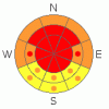
Danger by aspect and elevation on slopes approaching 35° or steeper.
(click HERE for tomorrow's danger rating)


Danger Rose Tutorial

Click here to see the newly revised North American Avalanche Danger Scale.

Avalanche dangers have risen to HIGH in the Mountains of SE Utah with the new snow alone. We also have continued reactivity on buried Surface Hoar. The danger is worst on E-NE-NW-W facing slopes where new snow drifting and the weakest old snow are likely to be found.

Excellent conditions are still being reported from shady aspects in the Mountains of SE Utah. More snow is forecast Through the week so it is not going to be a great time to test yourself in the backcountry. Steep slopes are going to be scary.


CURRENT CONDITIONS

A foot to a foot and a half has fallen over the La Sal and Abjao Mountains with more falling the farther south you are. We've reached that magic in of water total the send avalanche dangers through the roof. We can expect HIGH avalanche dangers here in SE Utah. We can also expect hero snow conditions so yeehaw.

Expect 4wd or Chains to be necessary to get to the La Sal trailheads this morning

Grooming will have to wait.


RECENT ACTIVITY

Some dry loose activity noted on NE face of Tukno Saturday, things should get more interesting.


THREAT #1

WHERE PROBABILITY SIZE TREND
      Over the next 48 hours.

We've reached the threshold value for high avalanche danger here in the La Sals and we're well over it in the Abajos. Keep the slopes angles below 30 degrees unless you're comfortable making a full stability analysis of any slope you are considering skiing that exceeds that steepness. Natural and Human triggered avalanches are likely at this time.


THREAT #2

WHERE PROBABILITY SIZE TREND
      Over the next 48 hours.

We still have buried surface hoar layers that could be re-activated with the weight of the new snow. The first is now buried 2.5-3 feet down in the snow pack. The last is buried about 12-15 inches down (depending on the depth of wind drifting) and was formed during last week's high pressure. We are not used to dealing with this phenomena too often down here in SE Utah, and the instability regarding this persistent weak layers seems to be very long lasting. I did extensive testing on this layer earlier lastweek and found it to still be very reactive in snowpit tests. Disturbingly so. Take a look for this layer in the snowpack, and see if it has formed where you want to ski. Some expertise will be required here. If you are unable to perform simple layer identification in the snowpack, then stay on low angled terrain or the North Woods.


MOUNTAIN WEATHER

National Weather Service Forecast for 10,000 Ft. :

Today:

Snow likely, mainly before 11am. Mostly cloudy, with a high near 29. West southwest wind around 5 mph. Chance of precipitation is 60%. Total daytime snow accumulation of 1 to 2 inches possible.

Tonight:

A 20 percent chance of snow. Mostly cloudy, with a low around 18. West southwest wind around 5 mph becoming south southeast.

Tuesday:

Snow likely, mainly after 11am. Mostly cloudy, with a high near 29. South wind around 5 mph. Chance of precipitation is 70%. New snow accumulation of 1 to 3 inches possible.

Tuesday Night:

Snow likely. Mostly cloudy, with a low around 16. West northwest wind between 5 and 10 mph. Chance of precipitation is 60%. New snow accumulation of 1 to 3 inches possible.

Wednesday:

A 40 percent chance of snow. Mostly cloudy, with a high near 26. West wind between 10 and 15 mph, with gusts as high as 30 mph.

Wednesday Night:

A 30 percent chance of snow. Mostly cloudy and blustery, with a low around 11.

Thursday:

A 20 percent chance of snow. Mostly cloudy, with a high near 26.

Thursday Night:

Partly cloudy, with a low around 12.


GENERAL ANNOUNCEMENTS

We would like to thank the hard working volunteers at the Friends of the La Sal Avalanche Center. Without their help the center would not meet it's funding or staffing requirements. Thanks all! If you would like more information about donating to the Friends or simply helping out, click here..

This advisory will expire in 48 hours.

We cannot receive messages on our 259-SNOW line. If you would like to leave us an observation or a message, you my reach us at 435-636-3363.


This information does not apply to developed ski areas or highways where avalanche control is normally done.  This advisory is from the U.S.D.A. Forest Service, which is solely responsible for its content. This advisory describes general avalanche conditions and local variations always occur.


This advisory provided by the USDA Forest Service, in partnership with:

The Friends of the Utah Avalanche Center, Utah Division of State Parks and Recreation, Utah Division of Emergency Management, Salt Lake County, Salt Lake Unified Fire Authority and the friends of the La Sal Avalanche Center. See our Sponsors Page for a complete list.