Moab Avalanche Advisory

Forecaster: Dave Medara

BOTTOM LINE

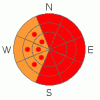
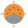
Danger by aspect and elevation on slopes approaching 35° or steeper.
(click HERE for tomorrow's danger rating)


Danger Rose Tutorial

Click here to see the newly revised North American Avalanche Danger Scale.

Dumpage. 12-15" of pretty heavy powder in the La Sals. A bit less in the Abajos. More on the way. Expect to find HIGH avalanche danger in the La Sal and Abajo Mountains on slopes steeper than 30 degrees.

Great Conditions being reported from both mountain ranges today. Impressive light show driving back up from avalanche talk at the Monticello Winter Festival tonight. Frontal passage brought a rare winter lightning event (and a severe blizzard) with thunder to boot. Keep the mountain thunder in the sky and keep the slopes angles below 30 degrees folks.


CURRENT CONDITIONS

Excellent skiing and riding conditions were being reported today from both the La Sal and Abajo Mountains today. 12-15 inches of new snow has fallen in the La Sal Mountains so far. The Abajo Snotel site is only showing 4" of new snow but the reports from a skier down there today are of " a foot of new snow" at the old Blue Mountain Ski area. The stuff is pretty heavy, over 10% and with plenty of west winds today the better conditions will be found below treeline.

Roads have not been plowed so expect full on 4wd battle conditions to Mountain Trailheads until San Juan County can get up there to clear the roads.

Grooming on the La Sal Nordic Track will have to wait until next week when this storm tapers off.


RECENT ACTIVITY

Nothing noted from this storm yet. Lots of avalanche activity in the La Sals and in Colorado over the past week. Things are going to get even more spicy. Many incidents involving skiers including a fatality near Ridgeway, CO with a snowpack that nearly mirrors ours.


THREAT #1

WHERE PROBABILITY SIZE TREND
      Over the next 48 hours.

Click here to see the newly revised North American Avalanche Danger Scale.

Ok, It's a no-brainer now. We've had 12-15 inches of new snow (critical Value) over and inch of new water weight (critical value) and over 6 hours of winds in the 15-30 MPH range (critical value). The Avalanche Danger Rating is generally HIGH. Normally safer SE facing slopes (such as Goldminers) may be loaded by winds out of the west for most of the day. This is an unusual prevailing wind direction for us so far in this storm, so expect to see some different wind loading patterns in the Mountains of SE Utah than we are used to seeing. Stay off of, and out from under slopes steeper than 30 degrees for the next few days.


THREAT #2

WHERE PROBABILITY SIZE TREND
      Over the next 24 hours.

We still have some pretty serious issues with our "old" snow. First is a buried layer of surface hoar that is now about 2-3 feet below the surface of the new snow. This layer continues to be reactive in snowpit tests. Tuesday I dug a lot of pits trying to determine the extent and distribution of the surface hoar layer and found it to be on open NE-NW facing slopes at and below treeline. No surprise there. Unfortunately what I found where the surface hoar layer didn't exist, was a layer of near-surface facets at the same level in the snowpack, that was equally reactive in snowpit tests. Another classic SW snowpack situation. Combine that with depth hoar that is can still be found in the lower third of the snowpack (producing the dramatic collapses still being felt in thinner snowpack areas) and we've got all three of the classic types of persistent weak layers at play in our SE Utah snowpack. As always approach steep slopes with respect here in SE Utah.


MOUNTAIN WEATHER

National Weather Service Forecast for 10,000 Ft. :

Tonight:

Snow. Low around 19. Breezy, with a west southwest wind between 10 and 20 mph, with gusts as high as 30 mph. Chance of precipitation is 100%. Total nighttime snow accumulation of 7 to 11 inches possible.

Saturday:

Snow. High near 26. Breezy, with a southwest wind between 15 and 25 mph, with gusts as high as 40 mph. Chance of precipitation is 100%. New snow accumulation of 6 to 10 inches possible.

Saturday Night:

Snow. Low around 15. West northwest wind between 10 and 15 mph. Chance of precipitation is 90%. New snow accumulation of 3 to 5 inches possible.

Sunday:

Snow likely. Cloudy, with a high near 19. Southwest wind between 5 and 15 mph. Chance of precipitation is 60%. New snow accumulation of 2 to 4 inches possible.

Sunday Night:

Snow likely. Cloudy, with a low around 9. West northwest wind around 5 mph. Chance of precipitation is 60%.

Monday:

A 20 percent chance of snow. Mostly cloudy, with a high near 17.

Monday Night:

A 20 percent chance of snow. Mostly cloudy, with a low around 5.


GENERAL ANNOUNCEMENTS

We would like to thank the hard working volunteers at the Friends of the La Sal Avalanche Center. Without their help the center would not meet it's funding or staffing requirements. Thanks all! If you would like more information about donating to the Friends or simply helping out, click here..

This advisory will expire in 48 hours.


This information does not apply to developed ski areas or highways where avalanche control is normally done.  This advisory is from the U.S.D.A. Forest Service, which is solely responsible for its content. This advisory describes general avalanche conditions and local variations always occur.


This advisory provided by the USDA Forest Service, in partnership with:

The Friends of the Utah Avalanche Center, Utah Division of State Parks and Recreation, Utah Division of Emergency Management, Salt Lake County, Salt Lake Unified Fire Authority and the friends of the La Sal Avalanche Center. See our Sponsors Page for a complete list.