Moab Avalanche Advisory

Forecaster: Dave Medara

BOTTOM LINE

Danger by aspect and elevation on slopes approaching 35° or steeper.
(click HERE for tomorrow's danger rating)


Danger Rose Tutorial

Click here to see the newly revised North American Avalanche Danger Scale.

The La Sal Mountains received 4-6 of new snow Monday night and conditions on shady slopes are excellent. Things really warmed up yesterday above the inversion layer and sunny side slopes are well crusted over. The Abajos did not fare as well receiving just a trace of new snow. Expect to find MODERATE avalanche dangers in the mountains of SE Utah right now. New snow over persistent weak layers continue to result in avalanches throughout our region. Even though localized and declining, the danger still exists. If you are unable to make an expert snowpack analysis of conditions exactly where you are considering skiing or riding, make a conservative decision and keep the slope angle below 30 degrees.


CURRENT CONDITIONS

It was a beautiful day in the mountains yesterday. Sunny and clear above the inverted valley fog layer. With 4-6" of new snow in the La Sals, it was one of those unexpected bonus days that sometimes get for sticking to the plan, even when your psyche for it is declining.We found some great conditions on West and NW facing slopes near Mt Tomasaki. Any slope with one degree more of a south aspect than we were on has breakable crust on it (below the new snow) , so keep your aspects as shady as possible for good conditions. We are not out of the woods yet avalanche wise either, so read on for more on that score.

Roads into the La Sal Mountain Trailheads have not been plowed yet but are passable with a 4wd vehicle.

Grooming efforts have been erased by 4-6 inches of new snow.


RECENT ACTIVITY

Skier release on a SW facing wind roll yesterday (intentional, on Mt Tomasaki) at treeline demonstrates what has been going on with the wind up high.


THREAT #1

WHERE PROBABILITY SIZE TREND
      Over the next 48 hours.

Click here to see the newly revised North American Avalanche Danger Scale.

Loaded and cross-loaded slopes at and above treeline should be approached with caution. Yesterday, small slabs were very reactive to the weight of a skier or rider. Winds have been out of the north so sunny side south facing slopes below ridgelines and other terrain features are most likely areas for starting a new-snow slide. Yesterday's warm temperatures will help heal this problem quickly. But heads up nonetheless, these things were really popping out.


THREAT #2

WHERE PROBABILITY SIZE TREND
      Over the next 24 hours.

We still have some pretty serious issues with our "old" snow. First is a buried layer of surface hoar about 16-20 inches below the surface of the new snow. This layer continues to be reactive in snowpit tests. Yesterday I dug a lot of pits trying to determine the extent and distribution of the surface hoar layer and found it to be on open NE-NW facing slopes at and below treeline. No surprise there. Unfortunately what I found where the surface hoar layer didn't exist, was a layer of near-surface facets at the same level in the snowpack, that was equally reactive in snowpit tests. Another classic SW snowpack situation. Combine that with depth hoar that is can still be found in the lower third of the snowpack (producing the dramatic collapses still being felt in thinner snowpack areas) and we've got all three of the classic types of persistent weak layers at play in our Se Utah snowpack. As always approach steep slopes with respect here in SE Utah


THREAT #3

WHERE PROBABILITY SIZE TREND
      Over the next 48 hours.

Watch out for wet slides as things warm up in the mountains today on SE-SW-W facing slopes. Lots of wet slides ran yesterday and today is likely to be warmer.


MOUNTAIN WEATHER

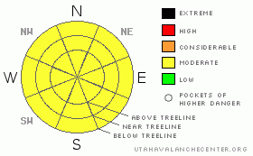
National Weather Service Forecast for 10,000 Ft. :

Today:

Partly sunny, with a high near 31. Calm wind becoming west southwest around 5 mph.

Tonight:

A 20 percent chance of snow. Mostly cloudy, with a low around 16. West wind around 5 mph becoming calm.

Thursday:

Snow likely. Cloudy, with a high near 28. West southwest wind between 5 and 10 mph. Chance of precipitation is 60%. New snow accumulation of less than one inch possible.

Thursday Night:

Snow likely. Cloudy, with a low around 14. West southwest wind around 5 mph. Chance of precipitation is 70%. New snow accumulation of around an inch possible.

Friday:

A 50 percent chance of snow. Cloudy, with a high near 28. Southeast wind 5 to 10 mph becoming southwest.

Friday Night:

A 50 percent chance of snow. Cloudy, with a low around 15.

Saturday:

Snow likely. Cloudy, with a high near 26. Chance of precipitation is 60%.

Saturday Night:

A chance of snow. Cloudy, with a low around 12.

Sunday:

A chance of snow. Cloudy, with a high near 23.


GENERAL ANNOUNCEMENTS

We would like to thank the hard working volunteers at the Friends of the La Sal Avalanche Center. Without their help the center would not meet it's funding or staffing requirements. Thanks all! If you would like more information about donating to the Friends or simply helping out, click here..

This advisory will expire in 48 hours.


This information does not apply to developed ski areas or highways where avalanche control is normally done.  This advisory is from the U.S.D.A. Forest Service, which is solely responsible for its content. This advisory describes general avalanche conditions and local variations always occur.


This advisory provided by the USDA Forest Service, in partnership with:

The Friends of the Utah Avalanche Center, Utah Division of State Parks and Recreation, Utah Division of Emergency Management, Salt Lake County, Salt Lake Unified Fire Authority and the friends of the La Sal Avalanche Center. See our Sponsors Page for a complete list.