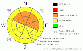
BOTTOM LINE
Danger by aspect and elevation on slopes approaching 35° or steeper.
(click HERE for tomorrow's danger rating)
|
Danger Rose Tutorial
|
Click here to see the newly revised North American Avalanche Danger Scale.
On shady slopes E-NE-NW facing you can expect to find a CONSIDERABLE avalanche danger. MODERATE avalanche danger exists on SE-S-W facing slopes.
The best skiing and riding conditions of the year are on tap in SE Utah at the moment. Unfortunately, very weak layers at various depth of the snowpack have conspired to make decision making in avalanche terrain quite tricky. The risk is high for the reward right now. The best idea is to keep your slope angles below 30 degrees. Shady side slopes are skiing very well on lower angled slopes at the moment, so if you are unable to make a careful snowpack analysis of the problems discussed below, keep your slope angles down. |
|
|
CURRENT CONDITIONS |

|
There has been an inch or two of new snow flurries over the last couple of days adding to the great conditions that are still being found in the mountains of SE Utah. Today we ski toured to South Mountain and found excellent skiing conditions on North facing slopes. Sunny side slopes caught a bit of sun today at lower elevations and conditions on the sunny aspects will be deteriorating. Today at South Mountain we measured over 7 feet of snow at about 10,500, which is a fair deep deeper than in the interior parts of the range. The variability in the depth of the snowpack across the mountains of SE Utah has some interesting implications avalanche wise, so read on for more information on that subject.
Roads to all mountain trailheads are open at the moment.
The entire La Sal Nordic track has been rolled and packed but it is still a bit soft. There are more volunteers headed up tomorrow to continue where Matt Hebbard (volunteer of the year) left off.
|
|
|
RECENT ACTIVITY |

|
There was limited avalanche activity associated with last week's storm. Today we were able to see some activity on SE facing slopes on South Mountain.
We also experienced shooting cracks on lower angle terrain where we skied today.
|
|
|
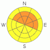
THREAT #1 |

|
| WHERE |
PROBABILITY |
SIZE |
TREND |
|
|
|
|
| |
|
|
Over the next
48 hours.
|
|
|
Click here to see the newly revised North American Avalanche Danger Scale.
We currently have 2 major problems with our snowpack in the La Sals. We'll talk about the one closer to the surface first.
14 " below the surface of the newest snow is a buried layer of Surface Hoar. This layer was the failure layer resulting in a couple of shooting cracks that were noted as we toured today. We targeted the Surface Hoar layer in several snowpit tests and found it to be quite weak, and backed off from our objective - the top of the East Ridge of S. Mountain - as a result.
This layer formed during the high pressure between our last two storms around February 1st. Strong effects of Solar Radiation and Wind usually destroy fragile Surface Hoar layers on the top of the snowpack before they can be buried and become a problem. Unusually light winds over the La Sal and Abajo mountains for the last few weeks have allowed the fragile Hoar crystals to survive and become buried by February 5-7 snowfall. Now we have a problem that we typically do not see in SE Utah.
The extent of the elevation range of this Surface Hoar layer are unknown. It will likely be found in open glades at and below treeline that are sheltered from wind and sun, similar to the mid-elevation North facing slope we were on today. Like faceted crystals and depth hoar, these grains, once buried, form a persistent weak layer that can linger for weeks, and right now, this layer is reactive to the weight of a person. The only action we can take to resolve this situation is to keep the slope angles you go out on below 30 degrees. Do yourself a favor before you jump into any steep north facing slopes right now and dig a quick pit. Target a grey looking band less than a half-inch thick that my be 1 to 2 feet below the snow surface. See if you can find it and how it acts, then make your decision.
|
|
|
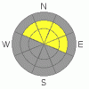
THREAT #2 |

|
| WHERE |
PROBABILITY |
SIZE |
TREND |
|
|
|
|
| |
|
|
Over the next
24
hours.
|
|
|
Persistent weak layers in the form of depth hoar and buried faceted grains can be found at 1/3 height in the snowpack and lower. Collapsing and "whoomphing" on these layers is still happening in thinner (less than about 4 feet) snowpack areas indicating that the potential for these deep, persistent weak layers to produce an avalanche still exists. While unlikely to be triggered by the weight of human, an avalanche of this type could release into old snow producing a large slide with severe consequences. Thinner snowpack areas over convexities near treeline are the most likely areas for this kind of event. Unlike the Surface Hoar issue discussed in the above paragraph, this is typical for our mountains in mid-winter. |
|
|
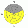
THREAT #3 |

|
| WHERE |
PROBABILITY |
SIZE |
TREND |
|
|
|
|
| |
|
|
Over the next
24
hours.
|
|
|
On Sunday and Monday, be careful on slopes steeper than 35 degrees when and if things warm up. The sun is getting strong and wet slides are going to become a real possibility as we move into spring. |
|
|
MOUNTAIN WEATHER |

|
National Weather Service Forecast for 10,000 Ft. :
Tonight:
A 50 percent chance of snow. Mostly cloudy, with a low around 16. West wind around 15 mph. Total nighttime snow accumulation of less than one inch possible.
Saturday:
Snow likely. Cloudy, with a high near 26. Blustery, with a west northwest wind between 15 and 20 mph, with gusts as high as 30 mph. Chance of precipitation is 60%. New snow accumulation of 1 to 2 inches possible.
Saturday Night:
A 40 percent chance of snow. Mostly cloudy, with a low around 12. Blustery, with a north northwest wind between 15 and 20 mph, with gusts as high as 30 mph.
Sunday:
Partly sunny, with a high near 26. Calm wind becoming north northwest around 5 mph.
Sunday Night:
Mostly cloudy, with a low around 14. North northwest wind around 5 mph.
Presidents' Day:
Partly sunny, with a high near 31. |
|
|
GENERAL ANNOUNCEMENTS |
As the season gets underway, we would like to thank the hard working volunteers at the Friends of the La Sal Avalanche Center. Without their help the center would not meet it's funding or staffing requirements. Thanks all! If you would like more information about donating to the Friends or simply helping out, click here..
This advisory will expire in 48 hours. |
|
|
This information does not apply to developed ski areas or highways where avalanche control is normally done. This advisory is from the U.S.D.A. Forest Service, which is solely responsible for its content. This advisory describes general avalanche conditions and local variations always occur. |
|
This advisory provided by the USDA Forest Service, in partnership with:
The Friends of the Utah Avalanche Center, Utah Division of State Parks and Recreation, Utah Division of Emergency Management, Salt Lake County, Salt Lake Unified Fire Authority and the friends of the La Sal Avalanche Center. See our Sponsors Page for a complete list. |
