BOTTOM LINE
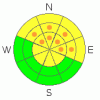
Danger by aspect and elevation on slopes approaching 35° or steeper.
(click HERE for tomorrow's danger rating)
|

Danger Rose Tutorial
|
Click here to see the newly revised North American Avalanche Danger Scale.
MODERATE Avalanche Danger in the Mtns. of SE Utah including the La Sal and Abajo ranges. High pressure of last week, warming temperatures and time have all contributed to "heal up" our SE Utah snowpack. Great conditions can be found on shady side slopes. We've had an inch or two of new snow overnight. Remember, MODERATE does not mean NO avalanche danger so ski conservatively or make an informed decision before you commit to avalanche terrain. Localized snow stability analysis is mandatory. Persistent weak layers exist in the lower third of the snowpack and while unlikely, triggering a slide on one of these deep weaknesses could be very costly
|
|
|
CURRENT CONDITIONS |

|
It looks like 1-2 inches of new snow has fallen in the La Sals and just a trace in the Abajos. Not much to highlite in a new forecast as Last Thursday's storm was a dud too, dropping only a 1/2 of snow in the La Sals and no measurable precip in the Abajos. But...the skiing and riding are excellent and it's not a bad thing to go into the weekend without a big spike in the avalanche danger. Stay tuned for more on that as the next storm approaches however. Great Powder Skiing on shady sides can be found in the Mountains of SE Utah at this time. Sunny sides are pretty crusty. There is some wind damage in the Alpine above treeline, but in sheltered areas the very good conditions can be found. We have 49" of snow at our Gold Basin Study Plot in the La Sals and we are at about 105% of normal. At Camp Jackson in the Abajos there is 55" of snow on the ground and they are at about 155% of normal.
Road access to the Dark Canyon Trailhead on the East side of the La Sals and the Geyser Pass TH in the La Sals are open and in great shape ( 4wd or chains recommended).The road is also plowed to the base of the old ski area in the Abajo Mtns. Great access. Consider a trip down to the old Blue Mountain Ski Resort for your next tour or a trip into North Canyon.
Finally, Matt Hebbard has once again, heroically, single handedly, groomed the entire nordic track for your cross country skiing pleasure. Dude of the year. Hopefully this new snow won't have too much of an affect on it.
|
|
|
RECENT ACTIVITY |

|
Tukno W face (R2D2), Taking Mountain Cirque (several R2D2), Upper Horse Creek (R3.5D3 - Impressive) Tukno NE face (several R2D2 onto Tele heaven and Tele gold) and the Funnel (R2D2) all ran during the MLK week storm. Many more slides ran during the storm but have been covered up by subsequent snow and are difficult to confirm. |
|
|
THREAT #1 |

|
| WHERE |
PROBABILITY |
SIZE |
TREND |
|
|
|
|
| |
|
|
Over the next
48 hours.
|
|
|
Click here to see the newly revised North American Avalanche Danger Scale.
Time has a way of mellowing things out. Even with persistent weak layers the snowpack molds, settles and hardens into place as mother nature adjusts to the load old man winter has dumped on her. It has been over a week since the the last significant snowfall across the region. Winds have been unusually light across the region for the last few days. A little point release activity and melt-freeze cycles during last week's warm high pressure (especially up high above inverted valley locations) have all but eliminated avalanche danger on SE through W facing sunny side slopes at all but the highest elevations. On shady side slopes, at least on the ones that didn't run during our last big storm cycle, bonds between layers in the snowpack are improving and stability is increasing. There has been a noticeable decline (we experienced none today) in collapsing and "whoomphing" of the snowpack, another sign that mother nature is adjusting to her load. For Saturday we are calling the Avalanche Danger Rating MODERATE with pockets of CONSIDERABLE danger below upper elevation NW-NE-E facing ridgelines with previous windloads. This may change before Sunday morning with the current forecast.
OK, Here's the caveat: If you do manage to make a bad decision and trigger a slide, it may be unsurvivable. I hesitate to lower the danger rating to MODERATE but do so based on the likelihood of actually triggering a slide. IF you manage to trigger a slide on one of our buried deep layer in the lower third of the snow pack it may very well be a deep slab on persistent weak faceted grains. As always, travel conservatively in the Mountains of SE Utah. Additionally, with the new snow over night, watch the winds as there is now snow availalble for transport should the winds bump up a notch. |
|
|
MOUNTAIN WEATHER |

|
National Weather Service Forecast for 10,000 Ft. :
Today: Snow likely. Cloudy, with a high near 29. South southwest wind around 5 mph, with gusts as high as 20 mph. Chance of precipitation is 60%. Total daytime snow accumulation of 1 to 2 inches possible.
Tonight: Snow. Low around 20. South southeast wind around 5 mph, with gusts as high as 20 mph. Chance of precipitation is 100%. New snow accumulation of 4 to 8 inches possible.
Sunday: Snow. High near 23. East wind around 5 mph becoming west. Winds could gust as high as 20 mph. Chance of precipitation is 100%. New snow accumulation of 3 to 7 inches possible.
Sunday Night: Snow. Low around 13. North northwest wind around 5 mph, with gusts as high as 20 mph. Chance of precipitation is 100%. New snow accumulation of 3 to 5 inches possible.
Monday: Snow likely, mainly before 11am. Cloudy, with a high near 19. North northwest wind around 5 mph, with gusts as high as 20 mph. Chance of precipitation is 60%.
Monday Night: A 20 percent chance of snow. Mostly cloudy, with a low around 9.
Tuesday: A 20 percent chance of snow. Mostly cloudy, with a high near 17.
|
|
|
GENERAL ANNOUNCEMENTS |
As the season gets underway, we would like to thank the hard working volunteers at the Friends of the La Sal Avalanche Center. Without their help the center would not meet it's funding or staffing requirements. Thanks all! If you would like more information about donating to the Friends or simply helping out, click here..
This advisory will expire in 48 hours!
|
|
|
This information does not apply to developed ski areas or highways where avalanche control is normally done. This advisory is from the U.S.D.A. Forest Service, which is solely responsible for its content. This advisory describes general avalanche conditions and local variations always occur. |
|
This advisory provided by the USDA Forest Service, in partnership with:
The Friends of the Utah Avalanche Center, Utah Division of State Parks and Recreation, Utah Division of Emergency Management, Salt Lake County, Salt Lake Unified Fire Authority and the friends of the La Sal Avalanche Center. See our Sponsors Page for a complete list. |
