AVALANCHE WARNING »
Dangerous avalanche conditions are occuring or are imminent.
Backcountry travel in avalanche terrain is not recommended.
|
 |
Notice: Notice:
Dangerous avalanche conditions are occurring or are imminent.
Backcountry travel in avalanche terrain is not recommended.
THE LA SAL AVALANCHE CENTER HAS ISSUED AN AVALANCHE WARNING IS FOR THE MOUNTAINS OF
SOUTHEASTERN UTAH INCLUDING THE LA SAL AND ABAJO MOUNTAINS
2 TO 5 FEET OF NEW SNOW COMBINED WITH STRONG WINDS HAS OVERLOADED BURIED
LAYERS OF WEAKER OLD SNOW, CREATING LARGE AND VERY
DANGEROUS AVALANCHE CONDITIONS. BACKCOUNTRY TRAVELERS SHOULD STAY OFF OF AND
OUT FROM UNDERNEATH ANY SLOPE STEEPER THAN ABOUT 30 DEGREES.
EXTREME AVALANCHE DANGER WILL PERSIST THROUGH THE WEEKEND. |
|
|
SPECIAL ANNOUNCEMENT |
 |
Please note the the LSAC has changed the date of our 3-day AIARE Level 1 avalanche class from the last weekend of January to the first weekend of February. The dates are now February 5,6,7. Click here for more info. |
|
|
BOTTOM LINE
Danger by aspect and elevation on slopes approaching 35° or steeper.
(click HERE for tomorrow's danger rating)
|
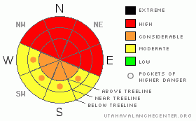
Danger Rose Tutorial
|
For today, the BOTTOM LINEfor the La Sal and Abajo Mountains will be an avalanche danger of HIGH, especially on steep, wind loaded slopes at all elevations. Only savvy back country skiers and snowmobilers should even think about recreating in these mountain ranges...everyone else go out and enjoy the desert. Conditions are so thick and brutal, be careful out there. |
|
|
CURRENT CONDITIONS |

|
Strong winds and heavy snow will make this weekend a dangerous one IF you are able to make it to the La Sal ans Abajo mountains. Over 6" of water equating to over 50" of snow has fallen in the Abajo Mountains, while the La Sal Mountains have picked what appears to be 4" of light density snow over Friday night, bringing the seven day total to 28".
The cold, light density snow that fell last light is just another layer in a predominantly upside down snow pack. Cracking and collapsing is widespread. Dense snow (15-18%) is overlying lighter layers (8%) and our old weak snow pack will make trail breaking conditions difficult and skiing conditions punchy. Every day the skiing conditions should improve some. Please be very conservative.
The Geyser Pass Road has not been plowed. San Juan County might be able to get to it on Monday. The lower half has been wind swept...it will be very difficult to make it to the Squaw Springs trailhead. |
|
|
RECENT ACTIVITY |

|
Our snowmobile tour yesterday to the end of the Gold Basin Road confirmed what our weather stations were telling us. Lots of wind and snow. Two road cuts slid huge naturally on North aspects...crowns of 2' to 5' below 9,600'. It appeared that Noriega's face slid mid slope to the ground. Exxon's Folly did not appear to have slid, yet. |
|
|
THREAT #1 |

|
| WHERE |
PROBABILITY |
SIZE |
TREND |
|
|
|
|
| |
|
|
Over the next
48 hours.
|
|
|
Strong Southeast through Southwest winds have scoured those aspects through the week and deposited wind drifted snow on Northerly aspects. Stay off these wind-loaded slopes. Stay out from under these wind loaded slopes. Remote triggering is a possibility today. |
|
|
THREAT #2 |

|
| WHERE |
PROBABILITY |
SIZE |
TREND |
|
|
|
|
| |
|
|
Over the next
48 hours.
|
|
|
Prior to this storm, we had less than one meter of snow in most locations and very cold temperatures, which creates poor bonds and weak faceted crystals. With a heavy new load, these our snowpack WILL fail on these faceted layers. |
|
|
MOUNTAIN WEATHER |

|
Today...Snow likely. No snow accumulation. Highs in the 20s. Chance of snow 60 percent. Tonight...Mostly cloudy. Lows 10 to 20. West winds 10 to 15 mph after midnight. Sunday...Mostly sunny. Highs in the 20s. Northwest winds 10 to 15 mph. Sunday Night...Partly cloudy. Lows 10 to 20. Monday...Mostly sunny. Highs 25 to 35. Northwest winds 10 to 15 mph in the morning becoming light. |
|
|
This information does not apply to developed ski areas or highways where avalanche control is normally done. This advisory is from the U.S.D.A. Forest Service, which is solely responsible for its content. This advisory describes general avalanche conditions and local variations always occur. |
|
This advisory provided by the USDA Forest Service, in partnership with:
The Friends of the Utah Avalanche Center, Utah Division of State Parks and Recreation, Utah Division of Emergency Management, Salt Lake County, Salt Lake Unified Fire Authority and the friends of the La Sal Avalanche Center. See our Sponsors Page for a complete list. |
