AVALANCHE WARNING »
Dangerous avalanche conditions are occuring or are imminent.
Backcountry travel in avalanche terrain is not recommended.
|
 |
Notice: Dangerous avalanche conditions are occurring or are imminent.
Backcountry travel in avalanche terrain is not recommended.
THE LA SAL AVALANCHE CENTER HAS ISSUED AN AVALANCHE WARNING IS FOR THE MOUNTAINS OF
SOUTHEASTERN UTAH INCLUDING THE LA SAL AND ABAJO MOUNTAINS
2 TO 5 FEET OF NEW SNOW COMBINED WITH STRONG WINDS HAS OVERLOADED BURIED
LAYERS OF WEAKER OLD SNOW, CREATING LARGE AND VERY
DANGEROUS AVALANCHE CONDITIONS. BACKCOUNTRY TRAVELERS SHOULD STAY OFF OF AND
OUT FROM UNDERNEATH ANY SLOPE STEEPER THAN ABOUT 30 DEGREES.
EXTREME AVALANCHE DANGER WILL PERSIST THROUGH THE WEEKEND. |
|
|
SPECIAL ANNOUNCEMENT |
 |
Please note the the LSAC has changed the date of our 3-day AIARE Level 1 avalanche class from the last weekend of January to the first weekend of February. The dates are now February 5,6,7. Click here for more info. |
|
|
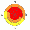
BOTTOM LINE
Danger by aspect and elevation on slopes approaching 35° or steeper.
(click HERE for tomorrow's danger rating)
|
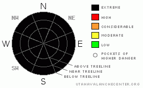
Danger Rose Tutorial
|
Click here to see the newly revised North American Avalanche Danger Scale.
High to Extreme Avalanche Danger exists in the Mountains of SE Utah right now including the La Sal and Abajo Mountains. Up to 2 to 5 feet of snow has piled up from a series of winter storms and more is on the way today. Backcountry travel is not recommended at this time. |
|
|
CURRENT CONDITIONS |

|
Impressive snow totals from this series of winter storms so far. We've measured 22" of new snow at 2.2 inches of water at the La Sal Snotel, and a over 50 inches of new snow and a massive 6.3 inches of water at the Abajo SNOTEL site. We'll get Gold Basin Totals today with snow machines, which may be the best way to get into the mountains today. If you do go into the mountains, stay well clear of ANY steep slopes.
Roads to the winter trailheads have NOT been cleared. SJ County will get to them as soon as they get their roads down south cleared out and it is a mess down there.It may be Monday before we get access to the mountains clear.
Grooming. Uh, no. Sunday's efforts will be all but gone. |
|
|
RECENT ACTIVITY |

|
Check out more info on avalanche classification here.
In limited visibility Wednesday we saw one slide on the west side of TUKNO, class R2D2+.
Lots of cracking and collapsing out there. Expect PLENTY of activity that we can't see. |
|
|
THREAT #1 |

|
| WHERE |
PROBABILITY |
SIZE |
TREND |

|
|
|
|
| |
|
|
Over the next
48 hours.
|
|
|
Click here to see the newly revised North American Avalanche Danger Scale.
Expect HIGH to EXTREME avalanche danger in the Mountains of SE Utah including the La Sal and Abajo Mountains. Particularly in the Abajos. In weather like this, it's easy to be an avalanche forecaster. With 2-5 feet of new snow, many hours of slab building winds from the south, and more snow on the way, the conclusions are easy to reach. Travel on or below steep slopes in mountain terrain (anything over 30 degrees) is not recommended. Rapid Loading from snow and winds have surpassed critical values for slab avalanche formation. Natural and Human triggered avalanches are likely in Mountain Terrain. |
|
|
THREAT #2 |

|
| WHERE |
PROBABILITY |
SIZE |
TREND |
|
|
|
|
| |
|
|
Over the next
48 hours.
|
|
|
While not exactly a likelyhood, there is the possibility of starting a very large, deep avalanche in the Mountains of SE Utah at this time. Various weak layers exist at all levels of the snowpack presently. What it would take to start a deep slab or for a smaller slab to step down into deeper layers, is anyone's guess. What we can tell you is that the snowpack structure for these types of Deep Slab Instabilities does exist right now. With more snow on the way the likelyhood of seeing these monsters is on the rise. The consequenses of triggering a deep slab could be dire. |
|
|
MOUNTAIN WEATHER |

|
National Weather Service Forecast for 10,000 Ft. : BLIZZARD WARNING IN EFFECT
Today: Snow. Some thunder is also possible. High near 27. Breezy, with a south southwest wind between 15 and 20 mph. Chance of precipitation is 100%. Total daytime snow accumulation of 4 to 8 inches possible. Tonight: Snow likely. Cloudy, with a low around 10. Southwest wind between 5 and 15 mph. Chance of precipitation is 70%. New snow accumulation of 1 to 3 inches possible. Saturday: A 50 percent chance of snow. Cloudy, with a high near 15. West southwest wind between 10 and 15 mph. New snow accumulation of 1 to 2 inches possible. Saturday Night: A 30 percent chance of snow. Cloudy, with a low around 9. West southwest wind between 5 and 15 mph. Sunday: A 30 percent chance of snow. Mostly cloudy, with a high near 18. West wind between 10 and 15 mph. Sunday Night: A 20 percent chance of snow. Mostly cloudy, with a low around 8. Monday: Partly sunny, with a high near 29. Monday Night: Mostly cloudy, with a low around 16.
|
|
|
GENERAL ANNOUNCEMENTS |
As the season gets underway, we would like to thank the hard working volunteers at the Friends of the La Sal Avalanche Center. Without their help the center would not meet it's funding or staffing requirements. Thanks all! If you would like more information about donating to the Friends or simply helping out, click here.
Local Avalanche Education:
LSAC Level One Avalanche Class - 3 days, February 5-7 - Call 435-636-3363 to reserve a spot or get more info.
This advisory will expire in 48 hours! |
|
|
This information does not apply to developed ski areas or highways where avalanche control is normally done. This advisory is from the U.S.D.A. Forest Service, which is solely responsible for its content. This advisory describes general avalanche conditions and local variations always occur. |
|
This advisory provided by the USDA Forest Service, in partnership with:
The Friends of the Utah Avalanche Center, Utah Division of State Parks and Recreation, Utah Division of Emergency Management, Salt Lake County, Salt Lake Unified Fire Authority and the friends of the La Sal Avalanche Center. See our Sponsors Page for a complete list. |
