SPECIAL ANNOUNCEMENT |
 |
Please note the the LSAC has changed the date of our 3-day AIARE Level 1 avalanche class from the last weekend of January to the first weekend of February. The dates are now February 5,6,7. Click here for more info. |
|
|
BOTTOM LINE
Danger by aspect and elevation on slopes approaching 35° or steeper.
(click HERE for tomorrow's danger rating)
|
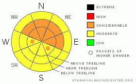
Danger Rose Tutorial
|
Click here to see the newly revised North American Avalanche Danger Scale.
CONSIDERABLE Avalanche Danger exist in the Mountains of SE Utah right now including the La Sal and Abajo Mountains. 6-10 of new snow has fallen across the region with a typically weak underlying snowpack. Conditions will be improving as far as snow quality goes, but it's time to back off from the steeps and re-evalutate the avalanche danger. More snow is on the way so avalanche dangers are bound to get worse before they get better. Please make a conservative, informed decision when you go into the backcountry. |
|
|
CURRENT CONDITIONS |

|
We've picked up 6" of new snow in the La Sals at the SNOTEL site at 9800 ft. and 10" down in the Abajos at 8600 ft. This snow is heavy and dense and this storm is favoring southern ranges. We're in a break between storms at the moment, with more on the way. Decent conditions have been reported up above treeline in the Alpine bowls of the La Sals on Re-crystallized powder. This week's snowfall should improve conditions at lower elevations and that old re-crystallized powder may turn into a weak layer for new snow to slide on so heads up.
Roads in the have NOT been cleared as of this afternoon. SJ County will get there as soon as they get their roads down south cleared out.
Grooming. Uh, no. Sunday's efforts will be all but gone. |
|
|
RECENT ACTIVITY |

|
Check out more info on avalanche classification here.
Nothing recent. Collapsing and cracking seem to be quieting down significantly. Expect a change in this section soon. |
|
|
THREAT #1 |

|
| WHERE |
PROBABILITY |
SIZE |
TREND |
|
|
|
|
| |
|
|
Over the next
48 hours.
|
|
|
Click here to see the newly revised North American Avalanche Danger Scale.
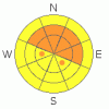
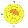
Bumping the Danger Rating up to CONSIDERABLE on slopes at and above treeline in the La Sals and above 8000 feet in the Abajos. Consistent winds out of the SW will bump the hazard up on East, Northeast and Northwest facing slopes and other aspects that might be cross-loaded. Our underlying snowpack is typically weak and this new snow will not bond well to the old snow surface composed of near surface faceted grains. Folks have been getting up into the Alpine Zone in the Mountains of SE Utah and it is time to take a step back. |
|
|
THREAT #2 |

|
| WHERE |
PROBABILITY |
SIZE |
TREND |
|
|
|
|
| |
|
|
Over the next
48 hours.
|
|
|
While not exactly a likelyhood, there is the possibility of starting a very large, deep avalanche in the Mountains of SE Utah at this time. Various weak layers exist at all levels of the snowpack presently. What it would take to start a deep slab or for a smaller slab to step down into deeper layers, is anyone's guess. What we can tell you is that the snowpack structure for these types of Deep Slab Instabilities does exist right now. With more snow on the way the likelyhood of seeing these monsters is on the rise. The consequenses of triggering a deep slab could be dire. |
|
|
MOUNTAIN WEATHER |

|
National Weather Service Forecast for 10,000 Ft. :
Late Afternoon: A 50 percent chance of snow. Cloudy, with a high near 24. South wind around 10 mph. Total daytime snow accumulation of 2 to 4 inches possible. Tonight: Snow, mainly after 11pm. Low around 15. South wind around 10 mph. Chance of precipitation is 80%. New snow accumulation of 2 to 4 inches possible. Wednesday: Snow. High near 29. Southeast wind between 5 and 10 mph becoming calm. Chance of precipitation is 90%. New snow accumulation of 3 to 5 inches possible. Wednesday Night: A 30 percent chance of snow. Cloudy, with a low around 14. South wind between 5 and 10 mph. Thursday: Snow. High near 30. South southeast wind around 15 mph. Chance of precipitation is 90%. Thursday Night: Snow. Low around 19. Breezy. Chance of precipitation is 90%. Friday: Snow. High near 29. Chance of precipitation is 80%. Friday Night: Snow likely. Cloudy, with a low around 12. Saturday: Snow likely. Cloudy, with a high near 21. Saturday Night: A chance of snow. Cloudy, with a low around 11. Sunday: Mostly cloudy, with a high near 24.
|
|
|
GENERAL ANNOUNCEMENTS |
As the season gets underway, we would like to thank the hard working volunteers at the Friends of the La Sal Avalanche Center. Without their help the center would not meet it's funding or staffing requirements. Thanks all! If you would like more information about donating to the Friends or simply helping out, click here.
Local Avalanche Education:
LSAC Level One Avalanche Class - 3 days, February 5-7 - Call 435-636-3363 to reserve a spot or get more info.
This advisory will expire in 48 hours! |
|
|
This information does not apply to developed ski areas or highways where avalanche control is normally done. This advisory is from the U.S.D.A. Forest Service, which is solely responsible for its content. This advisory describes general avalanche conditions and local variations always occur. |
|
This advisory provided by the USDA Forest Service, in partnership with:
The Friends of the Utah Avalanche Center, Utah Division of State Parks and Recreation, Utah Division of Emergency Management, Salt Lake County, Salt Lake Unified Fire Authority and the friends of the La Sal Avalanche Center. See our Sponsors Page for a complete list. |
