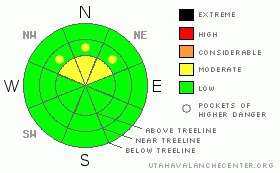
BOTTOM LINE
Danger by aspect and elevation on slopes approaching 35° or steeper.
(click HERE for tomorrow's danger rating)
|
Danger Rose Tutorial
|
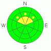
The bottom line for today in the La Sal and Abajo mountains will be an avalanche danger of MODERATE on slopes steeper than 35 degrees, at and above treeline, on NE-N-NW aspects. Watch out for ground hazards everywhere you go, but especially in the lower elevations. |
|
|
CURRENT CONDITIONS |

|
Decent skiing and riding conditions exist on NE-N-NW aspects at and above treeline in the La Sal and Abajo mountains. Cloud cover will limit warming for the rest of the Martin Luther King holiday, so south through west aspects will have treacherous variability in the form of punchy, breakable crusts and hard pan surfaces. The snowpack is shallow and weak with a couple of layers that we'll be watching as a potentially significant line of storm systems march one after another into our region starting Monday. With each 1/2 inch of water and sustained wind event, the avalanche danger will rise in accordance to these relatively quick, new loads being applied. We were all able to get after it in the mountains last week and you still have today and tomorrow to take advantage of our good stability before the avalanche dragons start to take control of the mountains.
LUNA will be up today to groom the entire Nordic System. Thank you LUNA volunteers for providing a world-class skating surface! |
|
|
RECENT ACTIVITY |

|
There have been no new avalanches reported the last two days. |
|
|
THREAT #1 |

|
| WHERE |
PROBABILITY |
SIZE |
TREND |
|
|
|
|
| |
|
|
Over the next
48 hours.
|
|
|
Thin wind skins are the only real threat today at and above treeline on NE-N-NW aspects avalanche wise, although careening through a shallow band of rocks has a higher propensity to ruin your day, or at least the bases of your new skis. The wind skins have been deposited in a tesselated pattern and are producing quick, sudden planar shears. You will find them, most of them benign due to their size. Watch out for larger hollow sounding wind skins. |
|
|
MOUNTAIN WEATHER |

|
Today: A 20 percent chance of snow before 11am. Mostly cloudy, with a high near 42. North northwest wind around 5 mph becoming south. Tonight: Increasing clouds, with a low around 23. South southwest wind between 10 and 15 mph. M.L.King Day: Snow likely, mainly after 11am. Cloudy, with a high near 31. Breezy, with a south wind between 15 and 25 mph, with gusts as high as 40 mph. Chance of precipitation is 60%. New snow accumulation of 1 to 3 inches possible. Monday Night: Snow. Low around 26. Windy, with a south wind 15 to 20 mph increasing to between 30 and 35 mph. Winds could gust as high as 55 mph. Chance of precipitation is 80%. New snow accumulation of 4 to 8 inches possible. |
|
|
GENERAL ANNOUNCEMENTS |
Sign up for our three day Level IAIARE course on February 5th through the 7th. Call 435-636-3363 for more information or to sign up. |
|
|
This information does not apply to developed ski areas or highways where avalanche control is normally done. This advisory is from the U.S.D.A. Forest Service, which is solely responsible for its content. This advisory describes general avalanche conditions and local variations always occur. |
|
This advisory provided by the USDA Forest Service, in partnership with:
The Friends of the Utah Avalanche Center, Utah Division of State Parks and Recreation, Utah Division of Emergency Management, Salt Lake County, Salt Lake Unified Fire Authority and the friends of the La Sal Avalanche Center. See our Sponsors Page for a complete list. |
