SPECIAL ANNOUNCEMENT |
 |
Please note the the LSAC has changed the date of our 3-day AIARE Level 1 avalanche class from the last weekend of January to the first weekend of February. The dates are now February 5,6,7. Click here for more info. |
|
|
BOTTOM LINE
Danger by aspect and elevation on slopes approaching 35° or steeper.
(click HERE for tomorrow's danger rating)
|
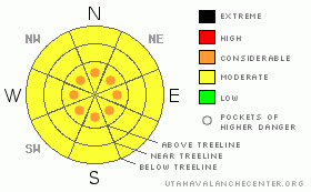
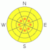
Danger Rose Tutorial
|
MODERATE avalanche dangers can be found in the Mountains of SE Utah at this time, but we are keeping pockets of CONSIDERABLE highlighted in the forecast for above treeline slopes steeper than 35 degrees. This is where winds consistently above the threshold 15MPH average have been at work. Best conditions will be found below treeline on shady E thru NW facing slopes.
Click here to see the newly revised North American Avalanche Danger Scale. |
|
|
CURRENT CONDITIONS |

|
Warmer temperatures can be found today especially above inverted valley locations ahead of a weak storm front that is headed our way. We're not gonna get much snow out of this one folks so the best skiing and riding conditions will still be found on shady slopes below treeline. Expect crustier conditions on SE thru W facing slopes and wind damage above treeline. Trip to the Abajos anyone? We are at 106% of normal snowpack for this time of year across the region.
San Juan County Road crews have done an awesome job with the road up to the Geyser Pass Trailhead. The road to the Dark Canyon trail access on the east side is also clear.
LUNA Groomers were up yesterday and were able to do the Upper Nordic Loop and over Geyser Pass. Thanks Max and Mark. |
|
|
RECENT ACTIVITY |

|
Check out more info on avalanche classification here.
Limited but large class II releases from the NE face of Tukno (Gravel Pit Lanes) were noted from last week's storm, but no other activity has been noted or reported. |
|
|
THREAT #1 |

|
| WHERE |
PROBABILITY |
SIZE |
TREND |
|
|
|
|
| |
|
|
Over the next
48 hours.
|
|
|
Click here to see the newly revised North American Avalanche Danger Scale.
We are dropping the Avalanche Danger Rating for SE Utah to MODERATE today, but keeping pockets of CONSIDERABLE in the forecast above treeline. Winds have been out of the Northwest so watch your self in the Funnel or Gold Miner's. Weak snowpack structures, Sustained winds over 15MPH and a large amount of light snow available for wind transport are keeping the avalanche mix a bit spicy. |
|
|
THREAT #2 |

|
| WHERE |
PROBABILITY |
SIZE |
TREND |
|
|
|
|
| |
|
|
Over the next
48 hours.
|
|
|
Areas that did not run during the December 8 or the December 30 avalanche cycles still have the potential to produce very large destructive avalanches. The likelyhood of triggering one of these persistent deep slabs is relatively low, and the consequences of being caught in one of these monsters is relatively high. Unless you know exactly what has avalanched and what hasn't, you're rolling the dice a bit with the weak "Colorado Snowpack" we have.
The cracking and collapsing that touring parties are still experiencing is a result of these buried weak layers in the snowpack. On steeper slopes, many of these "whumpfs" that people are experiencing would result in an avalanche. Please continue to make conservative travel decisions in the Mountains of SE Utah. |
|
|
MOUNTAIN WEATHER |

|
National Weather Service Forecast for 10,000 Ft. :
Today: A 20 percent chance of snow. Cloudy, with a high near 25. West southwest wind around 5 mph becoming calm. Tonight: A 30 percent chance of snow, mainly before 11pm. Mostly cloudy, with a low around 8. Calm wind becoming north northeast around 5 mph. Thursday: Partly sunny, with a high near 17. North northwest wind around 5 mph. Thursday Night: Partly cloudy, with a low around -5. North wind around 5 mph becoming east. Friday: Sunny, with a high near 23. Northeast wind between 5 and 10 mph. Friday Night: Mostly clear, with a low around 9. Saturday: Partly sunny, with a high near 28. Saturday Night: Mostly cloudy, with a low around 12. Sunday: A slight chance of snow. Mostly cloudy, with a high near 30.
|
|
|
GENERAL ANNOUNCEMENTS |
As the season gets underway, we would like to thank the hard working volunteers at the Friends of the La Sal Avalanche Center. Without their help the center would not meet it's funding or staffing requirements. Thanks all! If you would like more information about donating to the Friends or simply helping out, click here.
Local Avalanche Education:
Basic Avalanche Awareness Class - Grand County Library, January 12th - 5:30 - 8:00 PM.
LSAC Level One Avalanche Class - 3 days, February 5-7 - Call 435-636-3363 to reserve a spot or get more info.
This advisory will expire in 48 hours! |
|
|
This information does not apply to developed ski areas or highways where avalanche control is normally done. This advisory is from the U.S.D.A. Forest Service, which is solely responsible for its content. This advisory describes general avalanche conditions and local variations always occur. |
|
This advisory provided by the USDA Forest Service, in partnership with:
The Friends of the Utah Avalanche Center, Utah Division of State Parks and Recreation, Utah Division of Emergency Management, Salt Lake County, Salt Lake Unified Fire Authority and the friends of the La Sal Avalanche Center. See our Sponsors Page for a complete list. |
