SPECIAL ANNOUNCEMENT |
 |
Please note the the LSAC has changed the date of our 3-day AIARE Level 1 avalanche class from the last weekend of January to the first weekend of February. The dates are now February 5,6,7. Click here for more info. |
|
|
BOTTOM LINE
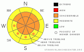
Danger by aspect and elevation on slopes approaching 35° or steeper.
(click HERE for tomorrow's danger rating)
|

Danger Rose Tutorial
|
CONSIDERABLE Avalanche Danger exists in the Mountains of SE Utah including the La Sal and Abajo Mountains. Good skiing and riding conditions can be found but, steep slopes are required to successfully slide down some of the deep snow we are finding in the La Sals especially. This is creating a fine line between skiability and safety. Users must decide if the risk is worth it based on observations gathered before you reach any risky objectives.
Click here to see the newly revised North American Avalanche Danger Scale. |
|
|
CURRENT CONDITIONS |

|
High pressure is settling in over SE Utah at least for the next couple of days. More snow would be nice be we can't complain after a 20 inch dump like the last one with light density snow and light winds. This was an exceedingly rare event for this area. Too bad it couldn't stay that nice. Yesterday, the winds finally came up, as they do, and there was an ominous roar overhead on our tour to Tele-Heaven. The change in the new snow is on, especially above treeline and that nice, low density Utah Powder is getting moved around and thickened up. On our tour yesterday we found that the snow was still too deep to ski anything less than about 30 degrees, so there is a fine line between risk and reward at the moment. We are still in a weak winter snowpack situation and with these winds, avalanche dangers will be out there still.
San Juan County Road crews have done an awesome job with the road up to the Geyser Pass Trailhead. The road to the Dark Canyon trail access was cleared during the day on Wednesday.
LUNA Groomers were up yesterday and were able to do the Lower Nordic Loop and into Gold Basin. Thanks Kirsten and Tony. |
|
|
RECENT ACTIVITY |

|
Check out more info on avalanche classification here.
Fairly Large class II activity in Tukno from this last storm yesterday provided us with safe acccess into Tele Heaven and Tele Gold. Slides had run in Main Chute of the NE face of Tukno (aka Gravel Pit Lanes) and below the cliffs in Tele Gold. |
|
|
THREAT #1 |

|
| WHERE |
PROBABILITY |
SIZE |
TREND |

|
|
|
|
| |
|
|
Over the next
48 hours.
|
|
|
Click here to see the newly revised North American Avalanche Danger Scale.
We are keeping the Avalanche Danger Rating for SE Utah at CONSIDERABLE today. Weak snowpack structures, increasing winds, and a large amount of light snow available for wind transport should keep the backcountry traveler on their toes today, especially at and above treeline. Scary results from stability tests on the new snow are being reported from up high on Pre-Laurel Peak near the Funnel. Winds are out of the Northwest today so heads up on sunny side slopes as well. These winds are no joke, so safe travel protocols in the Backcountry are mandatory today. |
|
|
THREAT #2 |

|
| WHERE |
PROBABILITY |
SIZE |
TREND |

|
|
|
|
| |
|
|
Over the next
48 hours.
|
|
|
Persistent deep weaknesses in the snowpack cannot be trusted this time of year in the SE Utah snowpack. This common scenario, sometimes referred to as a "Colorado Snowpack" leaves ski area snow safety personnel with grey hair and tight explosives budgets. We don't have explosive here so we have to be very careful.
The cracking and collapsing that touring parties are still experiencing is a result of these buried weak layers in the snowpack. On steeper slopes, many of these "whumpfs" that people are experiencing would result in an avalanche. Please continue to make conservative travel decisions in the Mountains of SE Utah. |
|
|
MOUNTAIN WEATHER |

|
National Weather Service Forecast for 10,000 Ft. :
Today: Mostly sunny, with a high near 25. Northwest wind between 5 and 10 mph. Tonight: Partly cloudy, with a low around 9. West wind around 5 mph. Monday: Mostly sunny, with a high near 23. West wind around 5 mph. Monday Night: Mostly cloudy, with a low around 11. West southwest wind around 5 mph becoming north. Tuesday: Mostly cloudy, with a high near 30. East wind around 5 mph becoming calm. Tuesday Night: Mostly cloudy, with a low around 13. Wednesday: A 20 percent chance of snow. Mostly cloudy, with a high near 24. Wednesday Night: A slight chance of snow. Mostly cloudy, with a low around 3. Thursday: Mostly sunny, with a high near 15.
|
|
|
GENERAL ANNOUNCEMENTS |
As the season gets underway, we would like to thank the hard working volunteers at the Friends of the La Sal Avalanche Center. Without their help the center would not meet it's funding or staffing requirements. Thanks all! If you would like more information about donating to the Friends or simply helping out, click here.
Local Avalanche Education:
Basic Avalanche Awareness Class - Grand County Library, January 12th - 5:30 - 8:00 PM.
LSAC Level One Avalanche Class - 3 days, February 5-7 - Call 435-636-3363 to reserve a spot or get more info.
This advisory will expire in 48 hours! |
|
|
This information does not apply to developed ski areas or highways where avalanche control is normally done. This advisory is from the U.S.D.A. Forest Service, which is solely responsible for its content. This advisory describes general avalanche conditions and local variations always occur. |
|
This advisory provided by the USDA Forest Service, in partnership with:
The Friends of the Utah Avalanche Center, Utah Division of State Parks and Recreation, Utah Division of Emergency Management, Salt Lake County, Salt Lake Unified Fire Authority and the friends of the La Sal Avalanche Center. See our Sponsors Page for a complete list. |

