BOTTOM LINE
Danger by aspect and elevation on slopes approaching 35° or steeper.
(click HERE for tomorrow's danger rating)
|
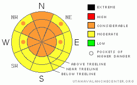
Danger Rose Tutorial
|
An avalanche danger of CONSIDERABLEwill be found in the mountains of southeast Utah. Stay off slopes greater than 35 degrees at and above treeline where new snow (sluffs), buried wind slabs and deep slab instability give way to numerous trigger points and greater risk. Let Mother Nature have her go in releasing avalanches for the time being, it would be a ominous start to the New Year. |
|
|
CURRENT CONDITIONS |

|
Happy New Year from Dave and Max at the La Sal Avalanche Center. 2010 is off to a great start in the mountains of Southeast Utah. The last storm of 2009 dropped 20" (50 cm) of 5% density snow up at the Gold Basin study plot, now with 48" (120 cm) on the ground. This will quickly settle out. The La Sal SNOTEL site has settled 8" to a 25" base in the last 30 hours.
Skiing and riding conditions have vastly improved but we are not giving the green light to go full throttle. Slow, cautionary combat skiing is in order...the low density snow is dangerously covering season ending logs and stumps in lower elevation areas. Winds above treeline have been uncharacteristically light, leaving a very enticing blanket of snow in areas that up the ante on the risk vs. reward scale. 20" of snow has surpassed a red flag criteria for this region. If you are heading out into avalanche terrain, take clues from mother nature and manage risk by staying in areas with less consequences and using safe travel techniques.
The San Juan County road crew was up yesterday in full force, and the road to the Geyser Pass trailhead is plowed. LUNA volunteers will start to set the corduroy this weekend.
This advisory will be updated Sunday morning. |
|
|
RECENT ACTIVITY |

|
Yesterdays short tour gave us some observations from Exxon's Folly and the Tuk No slide path. Slopes greater than 40 degrees had significant amounts of point releases, or sluff avalalanches on east through north aspects. A significant soft slab avalanche SS-N-R2D2-WI ripped out of the upper starting zone of Gravel Pit Lanes, the prominent NE facing shot off Tuk No, stopping in the paths upper track. Please call or email if you see any other significant avalanches this weekend. |
|
|
THREAT #1 |

|
| WHERE |
PROBABILITY |
SIZE |
TREND |
|
|
|
|
| |
|
|
Over the next
48 hours.
|
|
|
Winds during the first half of the storm had enough snow to transport onto leeward sides of slopes and ridges to create thin, reactive wind skins. Snow stability tests in Coyote Chute's starting zone yielded easy and moderate shears on this layer. Winds were strong enough from both north and south cardinal directions. These wind skins are buried and if they fail, could initiate larger, more dangerous deep slab avalanches.
When we do see a significant wind event, there is plenty of low density snow to transport, which will change our #1 threat to wind slabs. |
|
|
THREAT #2 |

|
| WHERE |
PROBABILITY |
SIZE |
TREND |
|
|
|
|
| |
|
|
Over the next
24
hours.
|
|
|
The 20" of new snow fell on a very weak snow pack, especially on Northerly aspects, where early season snow has been creating weaker bonds at the ground. Not all northerly aspects have flushed their system of this badness. Keep your guard up. We are still observing plenty of collapsing and cracking, and there is a potential to start large avalanches via remote triggering, in some cases maybe from the valley floor. |
|
|
MOUNTAIN WEATHER |

|
Today...Cloudy. Highs 25 to 35.
Tonight...Mostly cloudy with a 40 percent chance of snow. Lows 15 to 25.
Saturday...Mostly cloudy with a 30 percent chance of snow. Highs 25 to 35.
Saturday Night...Mostly cloudy. Lows 10 to 20.
Sunday...Mostly sunny. Highs in the 20s. Northwest winds 10 to 15 mph in the afternoon. |
|
|
GENERAL ANNOUNCEMENTS |
We would like to thank the hard working volunteers at the Friends of the La Sal Avalanche Center. Without their help, the center would not meet it's funding or staffing requirements. Thanks all!! If you would like to learn more about donating or helping the Friends, click here.
Local Avalanche Education:
Basic Avalanche Awareness Class - Grand County Library, January 12th - 5:30 - 8:00 PM.
LSAC Level One Avalanche Class - 3 days, January 29 - 31 - Call 435-636-3363 to reserve a spot or get more info.
This advisory will expire in 48 hours!
|
|
|
This information does not apply to developed ski areas or highways where avalanche control is normally done. This advisory is from the U.S.D.A. Forest Service, which is solely responsible for its content. This advisory describes general avalanche conditions and local variations always occur. |
|
This advisory provided by the USDA Forest Service, in partnership with:
The Friends of the Utah Avalanche Center, Utah Division of State Parks and Recreation, Utah Division of Emergency Management, Salt Lake County, Salt Lake Unified Fire Authority and the friends of the La Sal Avalanche Center. See our Sponsors Page for a complete list. |
