SPECIAL ANNOUNCEMENT |
 |
Happy Holidays from Dave and Max at the La Sal Avalanche Center! |
|
|
BOTTOM LINE
Danger by aspect and elevation on slopes approaching 35° or steeper.
(click HERE for tomorrow's danger rating)
|
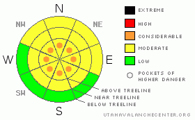
Danger Rose Tutorial
|
Improving skiing and riding conditions are happening in SE Utah. New snow has greatly improved the situation in the La Sal and Abajo Mountains. Overall Avalanche Danger is MODERATE but we are keeping pockets of CONSIDERABLE avalanche danger in the Alpine Zone above 11,500 feet where the winds have done the most slab formation.Expect rising avalanche dangers across the region with today's weather forecast.
Click here to see the newly revised North American Avalanche Danger Scale. |
|
|
CURRENT CONDITIONS |

|
New snow and warmer temperatures are on tap today as a winter storm continue over the SE Utah region. We've had 5 inches of new snow at the La Sal Snotel site, about 6 inches in Gold Basin and only about 2 inches at Camp Jackson in the Abajos. The skiing and riding conditions are excellent at the moment. Ground cover remains thin, especially in the North Woods. Snowfall over the holiday season is keeping us at about 105% of normal snowpack for this time of year.
The road to the Geyser Pass Trailhead was plowed yesterday, but another 3-4 inches of new snow has fallen since then at trailhead elevations. 4WD or Chains recommended.
LUNA Groomers are scheduled to groom the Nordic Track on Thursday. |
|
|
RECENT ACTIVITY |

|
Check out more info on avalanche classification here.
Localized cracking and collapsing are still being noted in the La Sals and the Abajos, but no reports of recent activity. The collapsing phenomena is less prevalent than it has been over the last few weeks at present. |
|
|
THREAT #1 |

|
| WHERE |
PROBABILITY |
SIZE |
TREND |
|
|
|
|
| |
|
|
Over the next
48 hours.
|
|
|
Click here to see the newly revised North American Avalanche Danger Scale.
To say that the new snow is falling on a weak base is an understatement. A snowpit Max and I dug yesterday in Coyote Chute yesterday describes two potential failure layers. The first is a layer of near-surface faceted crystals on top of the snow on the ground before the 12/22 storm. The second is weak, highly developed faceted crystals or depth hoar near the ground. Both of these layers could result in instabilities if they receive a critical load. This load is beginning to be applied, but with calmer winds than normal and low water weights so far in the storm we are still in pretty good shape. We are keeping the Avalanche Danger Rating at MODERATE but bumping a a bit higher to include pockets of CONSIDERABLE avalanche danger in the Alpine Zone above 11,500 feet where winds above 15mph have been at work.
Expect rising avalanche dangers if the current weather forecast verifies. |
|
|
MOUNTAIN WEATHER |

|
National Weather Service Forecast for 10,000 Ft. :
Today: Snow, mainly after 11am. High near 16. Southeast wind 10 to 15 mph becoming southwest. Winds could gust as high as 30 mph. Chance of precipitation is 90%. Total daytime snow accumulation of 2 to 4 inches possible. Tonight: Snow. Low around 9. West northwest wind between 10 and 15 mph, with gusts as high as 30 mph. Chance of precipitation is 80%. New snow accumulation of 5 to 9 inches possible. Thursday: A 20 percent chance of snow before 11am. Mostly cloudy, with a high near 25. North northwest wind around 5 mph becoming east. Thursday Night: Mostly cloudy, with a low around 9. South southwest wind around 5 mph. New Year's Day: A 20 percent chance of snow. Cloudy, with a high near 27. South southeast wind 5 to 10 mph becoming west. Friday Night: A 20 percent chance of snow. Cloudy, with a low around 16.
|
|
|
GENERAL ANNOUNCEMENTS |
As the season gets underway, we would like to thank the hard working volunteers at the Friends of the La Sal Avalanche Center. Without their help the center would not meet it's funding or staffing requirements. Thanks all! If you would like more information about donating to the Friends or simply helping out, click here.
Local Avalanche Education:
Basic Avalanche Awareness Class - Grand County Library, January 12th - 5:30 - 8:00 PM.
LSAC Level One Avalanche Class - 3 days, January 29 - 31 - Call 435-636-3363 to reserve a spot or get more info.
This advisory will expire in 48 hours! |
|
|
This information does not apply to developed ski areas or highways where avalanche control is normally done. This advisory is from the U.S.D.A. Forest Service, which is solely responsible for its content. This advisory describes general avalanche conditions and local variations always occur. |
|
This advisory provided by the USDA Forest Service, in partnership with:
The Friends of the Utah Avalanche Center, Utah Division of State Parks and Recreation, Utah Division of Emergency Management, Salt Lake County, Salt Lake Unified Fire Authority and the friends of the La Sal Avalanche Center. See our Sponsors Page for a complete list. |
