SPECIAL ANNOUNCEMENT |
 |
Happy Holidays from Dave and Max at the La Sal Avalanche Center! |
|
|
BOTTOM LINE
Danger by aspect and elevation on slopes approaching 35° or steeper.
(click HERE for tomorrow's danger rating)
|
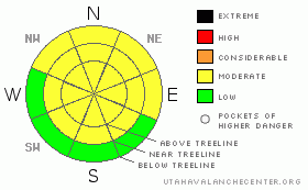
Danger Rose Tutorial
|
Good skiing and riding conditions are being reported in the La Sal and Abajo Mountains. Moderate avalanche Danger exists above treeline and in areas of the Abajo Mountains that had snow on the ground before the big early December snowfall. Although we're at about 110% of normal across the region, the snowpack is still thin. Expect early season conditions and poor ground hazard coverage.
Click here to see the newly revised North American Avalanche Danger Scale. |
|
|
CURRENT CONDITIONS |

|
Good skiing and riding conditions are at hand in the La Sal and Abajo Mountains. We measured 6" from this last storm at the Gold Basin Study Plot in the La Sals and 11 inches at Camp Jackson in the Abajos. We now have 28 inches of snow on the ground at the Gold Basin Plot, 29 inches at Camp Jackson in the Abajos. Compare that with the 18 inches at the LaSal Snotel site just above the winter trailhead. It's still early season in SE Utah. The snow is thin and "punchy" in places but reports are that it is skiing well. Continued below average temperatures across the region are forecast and it is very cold again this morning. This will help keep the snow nice on some of the sunnier runs off the Laurel Highway. It is 8 degrees F at my house in Moab and about the same at the Geyser Pass Trailhead.
The road to the Geyser Pass Trailhead has not been plowed but has had so much traffic it's passable with a 2WD vehicle. We were able to drive to the base of the old Blue Mountain Ski Area Wednesday (4WD) or you can park on the Blue Mtn. Loop Road and hike in the mile or so to the base of the runs. Skiing right back to the car definitely makes this the best access for backcountry skiing in SE Utah.
LUNA Groomers were up Friday and groomed the entire nordic track. No small effort. The track is groomed up and over Geyser Pass including the Upper and Lower Nordic loops and into Gold Basin. Thanks Groomers. |
|
|
RECENT ACTIVITY |

|
Check out more info on avalanche classification here.
Cracking and collapsing are still being noted in the La Sals and the Abajos, but no reports of recent activity. |
|
|
THREAT #1 |

|
| WHERE |
PROBABILITY |
SIZE |
TREND |
|
|
|
|
| |
|
|
Over the next
48 hours.
|
|
|
Click here to see the newly revised North American Avalanche Danger Scale.
Consistently cold temperatures and relatively well behaved winds are helping to ease up the stress in the snowpack and reduce the avalanche danger in SE Utah. Dropping the danger rating to MODERATE across the region although I do so with the caveat - We still have a very weak underlying snowpack composed of facted grains and depth hoar. Local analysis of your intended ski run or highmark should be made before you expose yourself to avalanche terrain. The areas of highest danger will be on or below East thru Northeast thru Northwest facing slopes steeper than 30 degrees. In the La Sals this means almost all shady side slopes above treeline. In the Abajos the danger will be highest where the was old snow on the ground before the early big early December dump.
Remember, expose only one skier or rider in your party at a time should you choose to enter avalanche terrain. Stay clear of the path until the rider or skier reaches a safe location before allowing the next "enthusiast" to enter. |
|
|
MOUNTAIN WEATHER |

|
National Weather Service Forecast for 10,000 Ft. :
Today: Partly sunny, with a high near 21. Calm wind becoming west between 5 and 10 mph. Tonight: Mostly cloudy, with a low around 4. West northwest wind around 5 mph becoming calm. Monday: Partly sunny, with a high near 21. Calm wind becoming west southwest between 5 and 10 mph. Monday Night: A 20 percent chance of snow. Mostly cloudy, with a low around 10. West wind around 5 mph becoming calm. Tuesday: A 20 percent chance of snow. Mostly cloudy, with a high near 19. Calm wind becoming west northwest around 5 mph. Tuesday Night: A 30 percent chance of snow. Mostly cloudy, with a low around 10. Wednesday: A 30 percent chance of snow. Mostly cloudy, with a high near 18. Wednesday Night: A chance of snow. Mostly cloudy, with a low around 5. Thursday: A chance of snow. Mostly cloudy, with a high near 17.
|
|
|
GENERAL ANNOUNCEMENTS |
As the season gets underway, we would like to thank the hard working volunteers at the Friends of the La Sal Avalanche Center. Without their help the center would not meet it's funding or staffing requirements. Thanks all! If you would like more information about donating to the Friends or simply helping out, click here.
Local Avalanche Education:
Basic Avalanche Awareness Class - Grand County Library, January 12th - 5:30 - 8:00 PM.
LSAC Level One Avalanche Class - 3 days, January 29 - 31 - Call 435-636-3363 to reserve a spot or get more info.
This advisory will expire in 48 hours! |
|
|
This information does not apply to developed ski areas or highways where avalanche control is normally done. This advisory is from the U.S.D.A. Forest Service, which is solely responsible for its content. This advisory describes general avalanche conditions and local variations always occur. |
|
This advisory provided by the USDA Forest Service, in partnership with:
The Friends of the Utah Avalanche Center, Utah Division of State Parks and Recreation, Utah Division of Emergency Management, Salt Lake County, Salt Lake Unified Fire Authority and the friends of the La Sal Avalanche Center. See our Sponsors Page for a complete list. |
