SPECIAL ANNOUNCEMENT |
 |
Happy Holidays from Dave and Max at the La Sal Avalanche Center! |
|
|
BOTTOM LINE
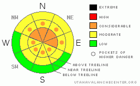
Danger by aspect and elevation on slopes approaching 35° or steeper.
(click HERE for tomorrow's danger rating)
|
Danger Rose Tutorial
|
New snows across the region have bumped the Avalanche Danger up to CONSIDERABLE across SE Utah in the La Sal and Abajo Mountains. The Abajos have picked up 11 inches and the La Sals 4 inches. Great skiing and riding conditions can be found in the Abajos with a more firm base for skiing and riding than in the La Sals. Check it out, but keep the slope angles down! Areas below treeline sheltered from the wind are providing the best conditions.
Click here to see the newly revised North American Avalanche Danger Scale. |
|
|
CURRENT CONDITIONS |

|
Storm totals from the SNOTEL sites were 4 inches in the La Sals and 11 Inches in the Abajos. Cold and Blustery Conditions were on tap for our Tour into the old Blue Mountain Ski Area yesterday. With the Abajos racking up about 3X more snow than the La Sals, we decided to head south for the day and it was not a waste of gas. Conditions were excellent. Powder skiing in SE Utah has finally arrived, at least down there. In the La Sals, it won't be quite as epic, and having old snow on the ground longer here in the La Sals leaves us with a weaker base and "punchier" skiing and riding. Expect Cold Conditions out there today folks! This will help keep the snow nice in the Laurel Meadows and Julie's Glade.
The road to the Geyser Pass Trailhead has NOT been plowed but is apparently in good shape. 4wd or Chains recommended. We were able to drive to the base of the old Blue Mountain Ski Area yesterday (4WD) or you can park on the Blue Mtn. Loop Road and hike in the mile or so to the base of the runs. Skiing right back to the car definitely makes this the best access for backcountry skiing in SE Utah.
LUNA Groomers are headed up today to lay down some corduroy before the Christmas weekend. A late start to the mountain today will provide for some great conditions for cross-country and skate skiing. |
|
|
RECENT ACTIVITY |

|
Check out more info on avalanche classification here.
Cracking and collapsing were still being noted on our tour yesterday. We had no visibility for any avalanche observations. |
|
|
THREAT #1 |

|
| WHERE |
PROBABILITY |
SIZE |
TREND |

|
|
|
|
| |
|
|
Over the next
48 hours.
|
|
|
Click here to see the newly revised North American Avalanche Danger Scale.
New snow combined with our classic SW winds have driven the avalanche danger upwards in Mountains of SE Utah. Anyone who has traveled around in the Mountains lately and had the hill side they were on collapse and drop them an inch or so knows this is no joke. WInd slabs have been deposited on open and above treeline slopes. Our underlying snowpack is very weak at the old snow surface and at about 1/3 height in the old snow. This weak snow is as common at these latitudes as it is predictable. There WILL be avalanches in the Abajos with 11 inches of new and there are likely to be avalanches in the La Sals. Human triggered avalanches are likely in both areas. Heads up! Keep the slope angle below 30 degrees. The avalanche danger will be higher on East thru Northeast Thru Northwest facing slopes as these are the slopes that are downwind of the prevailing SW winds we've had in the storm. Watch out though, as winds have changed to northerly and ratcheted up the speeds a bit. Upper elevation SE thru S thru West facing slopes may not provide the sanctuary they often can. WInd Loading is likely on upper elevation South facing slopes so it is probably not a good day to check out the Funnel! |
|
|
MOUNTAIN WEATHER |

|
National Weather Service Forecast for 10,000 Ft. :
Today: A 20 percent chance of snow before 11am. Partly cloudy, with a high near 17. Wind chill values as low as -10. Blustery, with a north northwest wind between 15 and 20 mph, with gusts as high as 30 mph. Tonight: A 20 percent chance of snow. Mostly cloudy, with a low around -4. Wind chill values as low as -25. Blustery, with a west northwest wind 15 to 20 mph becoming south southeast. Winds could gust as high as 30 mph. Christmas Day: A 20 percent chance of snow. Mostly cloudy, with a high near 15. Wind chill values as low as -25. Blustery, with a north wind between 15 and 20 mph, with gusts as high as 30 mph. Friday Night: A 20 percent chance of snow before 11pm. Mostly cloudy, with a low around -5. Wind chill values as low as -20. Northeast wind between 10 and 15 mph. Saturday: Partly sunny, with a high near 18. North wind between 5 and 10 mph. Saturday Night: Partly cloudy, with a low around 4. Sunday: Partly sunny, with a high near 22.
|
|
|
GENERAL ANNOUNCEMENTS |
As the season gets underway, we would like to thank the hard working volunteers at the Friends of the La Sal Avalanche Center. Without their help the center would not meet it's funding or staffing requirements. Thanks all! If you would like more information about donating to the Friends or simply helping out, click here.
Local Avalanche Education:
Basic Avalanche Awareness Class - Grand County Library, January 12th - 5:30 - 8:00 PM.
LSAC Level One Avalanche Class - 3 days, January 29 - 31 - Call 435-636-3363 to reserve a spot or get more info.
This advisory will expire in 48 hours! |
|
|
This information does not apply to developed ski areas or highways where avalanche control is normally done. This advisory is from the U.S.D.A. Forest Service, which is solely responsible for its content. This advisory describes general avalanche conditions and local variations always occur. |
|
This advisory provided by the USDA Forest Service, in partnership with:
The Friends of the Utah Avalanche Center, Utah Division of State Parks and Recreation, Utah Division of Emergency Management, Salt Lake County, Salt Lake Unified Fire Authority and the friends of the La Sal Avalanche Center. See our Sponsors Page for a complete list. |
