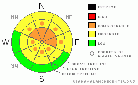
BOTTOM LINE
Danger by aspect and elevation on slopes approaching 35° or steeper.
(click HERE for tomorrow's danger rating)
|
Danger Rose Tutorial
|
New snows across the region have bumped the Avalanche Danger up to CONSIDERABLE across SE Utah in the La Sal and Abajo Mountains. The Abajos have picked up 11 inches and the La Sals 4 inches. Not exactly the dump we were hoping for in the La Sals, but a welcome dose of the white stuff for Christmas. This will improve turning and riding conditions, especially down south in the Abajos, but beware of the thin ground cover out there.
Click here to see the newly revised North American Avalanche Danger Scale. |
|
|
CURRENT CONDITIONS |

|
It looks like the Abajos have again edged us out here in the La Sals with 11 inches of new snow compared to our paltry 4 inches in the La Sals. We picked up another 4/10ths of an inch of water while the Abajos picked up another 1.2 inches. This will freshen things up a bit and make for some improved skiing and riding conditions, especially down south.
Don't expect any roads to be plowed to trailheads today. With only 4 inches of new snow, roads to La Sal trailheads should be passable w/ 4WD.
LUNA volunteers groomed up and over Geyser Pass Monday. How the nordic tracks fared with yesterdays snow is anybody's guess, but I'd wager the skate skiing is a bit past it's prime.
We'll confirm access, trail conditions snow totals throughout the day today. |
|
|
RECENT ACTIVITY |

|
Check out more info on avalanche classification here.
No recent activity, cracking and collapsing still being noted in the snowpack. |
|
|
THREAT #1 |

|
| WHERE |
PROBABILITY |
SIZE |
TREND |
|
|
|
|
| |
|
|
Over the next
48 hours.
|
|
|
Click here to see the newly revised North American Avalanche Danger Scale.
New snow combined with our classic SW winds are driving the avalanche danger upwards in Mountains of SE Utah. Anyone who has traveled around in the Mountains lately and had the meadow they were standing in, or the hill side they were on, collapse and drop them an inch or so knows this is no joke. Our underlying snowpack is very weak at the old snow surface and at about 1/3 height in the old snow. This weak snow is as common at these latitudes as it is predictable. There WILL be avalanches in the Abajos with 11 inches of new and there are likely to be avalanches in the La Sals. Human triggered avalanches are likely in both areas. Heads up! Keep the slope angle below 30 degrees. The avalanche danger will be higher on East thru Northeast Thru Northwest facing slopes as these are the slopes that are downwind of the prevailing SW winds we've had in the storm. Watch out though, as winds has uncharacteristically changed to northerly and ratcheted up the speeds a bit. Upper elevation SE thru S thru West facing slopes may not provide the sanctuary they often can.
|
|
|
MOUNTAIN WEATHER |

|
National Weather Service Forecast for 10,000 Ft. :
Today: Occasional snow. High near 23. Blustery, with a north northwest wind between 15 and 25 mph, with gusts as high as 35 mph. Chance of precipitation is 90%. Total daytime snow accumulation of 2 to 4 inches possible. Tonight: A 40 percent chance of snow. Mostly cloudy, with a low around 8. Northwest wind between 10 and 15 mph. Thursday: A 20 percent chance of snow. Mostly cloudy, with a high near 14. Wind chill values as low as -10. Blustery, with a north northwest wind between 15 and 20 mph, with gusts as high as 30 mph. Thursday Night: Mostly cloudy, with a low around -4. Wind chill values as low as -20. North northwest wind between 10 and 15 mph. Christmas Day: Mostly cloudy, with a high near 15. Northwest wind between 5 and 15 mph. Friday Night: Partly cloudy, with a low around -1. Saturday: Mostly sunny, with a high near 20.
|
|
|
GENERAL ANNOUNCEMENTS |
As the season gets underway, we would like to thank the hard working volunteers at the Friends of the La Sal Avalanche Center. Without their help the center would not meet it's funding or staffing requirements. Thanks all! If you would like more information about donating to the Friends or simply helping out, click here.
Local Avalanche Education:
Basic Avalanche Awareness Class - Grand County Library, January 12th - 5:30 - 8:00 PM.
LSAC Level One Avalanche Class - 3 days, January 29 - 31 - Call 435-636-3363 to reserve a spot or get more info.
This advisory will expire in 48 hours! |
|
|
This information does not apply to developed ski areas or highways where avalanche control is normally done. This advisory is from the U.S.D.A. Forest Service, which is solely responsible for its content. This advisory describes general avalanche conditions and local variations always occur. |
|
This advisory provided by the USDA Forest Service, in partnership with:
The Friends of the Utah Avalanche Center, Utah Division of State Parks and Recreation, Utah Division of Emergency Management, Salt Lake County, Salt Lake Unified Fire Authority and the friends of the La Sal Avalanche Center. See our Sponsors Page for a complete list. |
