BOTTOM LINE
Danger by aspect and elevation on slopes approaching 35° or steeper.
(click HERE for tomorrow's danger rating)
|
Danger Rose Tutorial
|
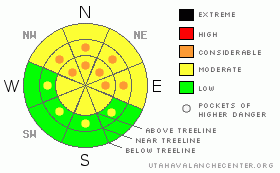
CONSIDERABLE Avalanche Danger remains in the Mountains of SE Utah. Fragile snowpack structures exist especially on high, windloaded, shady side slopes above treeline. Conditions throughout the region have improved with the snowfall of late, but cracking and collapsing are still being noted in the backcountry indicating that our snowpack is still tender. Keep the slope angles below 30 degrees and watch out for what's above you as remote triggering is a real possibilty.
Click here to see the newly revised North American Avalanche Danger Scale. |
|
|
CURRENT CONDITIONS |

|
High pressure has moved over SE Utah with warmer temperatures and valley inversions. In the last 8 days we've picked up 16 inches of new snow in the La Sals at our Gold Basin Study Plot and over 3 feet of new snow at Camp Jackson in the Abajos. Skiing and Riding Conditions are decent, but a bit inverted in with heavier snow on top. Sunny side slopes will be crusty with the warmer temps (38 degrees F at 9800') and ground cover is still on the sparse side. We have 27.5" of snow on the ground at our Gold BaSin Study Plot and the NRCS SNotel Study Plot above the Geyser Pass Trailhead has spiked up to 129% of normal with the last two storms.
Roads to the La Sal Mountain Trailheads (east and west sides) have been cleared by the San Juan County Road Crews. Thanks Guys.
Grooming efforts by LUNA volunteers this past Saturday were all but obliterated by new snow and winds but the lower Mountain Nordic trails have been packed and wanded. We are hoping to get at least the lower mountain groomed again on Friday. |
|
|
RECENT ACTIVITY |

|
Soft Slab Activity noted with last week's midweek storm: Mostly small pockets. Most appear to have run during the the storm. No activity has yet been noted for this last storm but expect there will have been some natural activity in the alpine zones. A Large release approximately 400' wide and running 1000' of vertical, to the ground, was noted on a north facing slope in upper North Creek of the Abajos yesterday.
In the La Sals:
Exxon's Folley - NN-SS-R2D2 50' x 400' upper observer's right.
Middle Cirque - The Cleavers NN-SS-R2D2 x 2 both of them.
Talking Mountain Cirque - NN-SSR2D2-O 100 x 1000' way right
Upper Horse Creek NN-SS-R2D2-G 150-1000' just at treeline
Check out more info on avalanche classification here. |
|
|
THREAT #1 |

|
| WHERE |
PROBABILITY |
SIZE |
TREND |

|
|
|
|
| |
|
|
Over the next
48 hours.
|
|
|
Click here to see the newly revised North American Avalanche Danger Scale.
Avalanche Dangers are quieting down in SE Utah with warmer temperatures and lighter winds. Cracking and Collapsing are still being noted however due to extremely weak snow about 1/3 height in the snowpack. This weak layer is the Faceted Grains of older snow that were on the ground and at the surface before last week's snowfall. These snow grains often form a weak and persistent substrata in the snowpack. With this layer in place on upper elevation East, through North through Northwest facing slopes we are keeping Pockets of CONSIDERABLE avalanche danger in the danger rating for today. This means that human-triggered avalanches are still likely in areas of wind deposition on these upper elevation shady side slopes. Expect to find a MODERATE avalanche danger elsewhere. Never completely trust the SE Utah snowpack at this time of winter. Good routefinding and safe travel protocols are in avalanche terrain are still mandatory.
To look at a recent snowpit profile from the La Sals click here. This pit shows a major weakness between the old snow/new snow interface. Likely problem at present is the even weaker snow beneath that interface. |
|
|
MOUNTAIN WEATHER |

|
National Weather Service Forecast for 10,000 Ft. :
Today: Partly sunny, with a high near 32. Southeast wind between 5 and 10 mph becoming calm. Tonight: Partly cloudy, with a low around 18. Calm wind becoming southeast around 5 mph. Thursday: Mostly sunny, with a high near 32. Southeast wind around 5 mph becoming calm. Thursday Night: Mostly cloudy, with a low around 19. Calm wind becoming north northeast around 5 mph. Friday: Partly sunny, with a high near 30. North northwest wind around 5 mph. Friday Night: Partly cloudy, with a low around 16. Saturday: Mostly sunny, with a high near 39. Saturday Night: Partly cloudy, with a low around 18. Sunday: Mostly sunny, with a high near 34. |
|
|
GENERAL ANNOUNCEMENTS |
As the season gets underway, we would like to thank the hard working volunteers at the Friends of the La Sal Avalanche Center. Without thier help the center would not meet it's funding or staffing requirements. Thanks all! If you would like more infomation about donating to the Friends or simply helping out, click here.
Local Avalanche Education:
Basic Avalanche Awareness Class - Grand County Library, January 12th - 5:30 - 8:00 PM.
LSAC Level One Avalanche Class - 3 days, January 29 - 31 - Call 435-636-3363 to reserve a spot or get more info. |
|
|
This information does not apply to developed ski areas or highways where avalanche control is normally done. This advisory is from the U.S.D.A. Forest Service, which is solely responsible for its content. This advisory describes general avalanche conditions and local variations always occur. |
|
This advisory provided by the USDA Forest Service, in partnership with:
The Friends of the Utah Avalanche Center, Utah Division of State Parks and Recreation, Utah Division of Emergency Management, Salt Lake County, Salt Lake Unified Fire Authority and the friends of the La Sal Avalanche Center. See our Sponsors Page for a complete list. |
