SPECIAL ANNOUNCEMENT |
 |
As the season gets underway, we would like to thank the hard working volunteers at the Friends of the La Sal Avalanche Center. Without thier help the center would not meet it's funding or staffing requirements. Thanks all! If you would like more infomation about donating to the Friends or simply helping out, click here. |
|
|
BOTTOM LINE
Danger by aspect and elevation on slopes approaching 35° or steeper.
(click HERE for tomorrow's danger rating)
|
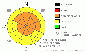
Danger Rose Tutorial
|
CONSIDERABLE Avalanche Danger in the Mountains of SE Utah. Avoid above Treeline slopes facing North, Northeast and East. Big winds and continued snowfall in SE Utah are keeping the danger of snow slides relatively high in our region. Expert route finding and conservative decision making are required of the backcountry traveler in SE Utah at this time.
Click here to see the newly revised North American Avalanche Danger Scale. |
|
|
CURRENT CONDITIONS |

|
We've picked up another 3-4 inches of heavy dense snow from this last storm over the weekend here in the La Sals. Once again it looks like the Abajos have picked up the lion's share of new snow with 8 inches of new snow and 1.6 inches of H2O. Inverted conditions with heavier new snow over the lighter density snow from midweek last week are being reported.
Trailhead access is unplowed as if this morning. Expect sporty conditions and big wind drifts. 4wd and Chains recommended and a big shovel for drifts.
LUNA volunteers were able to groom the Lower Meadow Loop and into Gold Basin Saturday at the LUNA groomer training. This work will be all but obliterated by high winds and new snow, but at least the track has been packed out and marked. Good work folks. |
|
|
RECENT ACTIVITY |

|
Soft Slab Activity noted with last week's midweek storm: Mostly small pockets. Most appear to have run during the the storm. No activity has yet been noted for this last storm but expect there will have been some natural activity in the alpine zones.
Exxon's Folley - NN-SS-R2D2 50' x 400' upper observer's right.
Middle Cirque - The Cleavers NN-SS-R2D2 x 2 both of them.
Talking Mountain Cirque - NN-SSR2D2-O 100 x 1000' way right
Upper Horse Creek NN-SS-R2D2-G 150-1000' just at treeline
Check out more info on avalanche classification here. |
|
|
THREAT #1 |

|
| WHERE |
PROBABILITY |
SIZE |
TREND |
|
|
|
|
| |
|
|
Over the next
48 hours.
|
|
|
Click here to see the newly revised North American Avalanche Danger Scale.
While not at Avalanche Warning levels the northern part of Utah is experiencing, the Avalanche Danger here in SE Utah remains at CONSIDERABLE. This means that Natural Avalanches are still possible and human triggered avalanches are likely. Small avalanches in many areas are possible. Yesterday morning we had big winds with hourly averages in the 40 MPH+ range from the South. Upper elevation East, through Northeast, through Northwest facing slopes will be nowhere you want to be. Widespread cracking and collapsing are still being experienced by touring parties indicating continued instability in the snow and real avalanche danger. Snow Coverage is improving and this last storm puts us well over 100% of normal snowfall for this time of year.
This advisory will expire in 48 hours! |
|
|
MOUNTAIN WEATHER |

|
National Weather Service Forecast for 10,000 Ft. : Drier Conditions expected.
Today: A 40 percent chance of snow, mainly before 11am. Cloudy, then gradually becoming mostly sunny, with a high near 21. Southwest wind between 5 and 10 mph. Tonight: Mostly cloudy, with a low around 13. West southwest wind around 5 mph becoming southeast. Tuesday: Partly sunny, with a high near 26. Southeast wind 5 to 10 mph becoming west southwest. Tuesday Night: Mostly cloudy, with a low around 15. Southwest wind around 5 mph becoming southeast. Wednesday: Partly sunny, with a high near 31. Calm wind. Wednesday Night: Partly cloudy, with a low around 17. Thursday: Mostly cloudy, with a high near 30. Thursday Night: Mostly cloudy, with a low around 17. |
|
|
GENERAL ANNOUNCEMENTS |
Basic Avalanche Awareness Class - Grand County Library, January 12th - 5:30 - 8:00 PM.
LSAC Level One Avalanche Class - 3 days, January 29 - 31 - Call 435-636-3363 to reserve a spot or get more info. |
|
|
This information does not apply to developed ski areas or highways where avalanche control is normally done. This advisory is from the U.S.D.A. Forest Service, which is solely responsible for its content. This advisory describes general avalanche conditions and local variations always occur. |
|
This advisory provided by the USDA Forest Service, in partnership with:
The Friends of the Utah Avalanche Center, Utah Division of State Parks and Recreation, Utah Division of Emergency Management, Salt Lake County, Salt Lake Unified Fire Authority and the friends of the La Sal Avalanche Center. See our Sponsors Page for a complete list. |
