BOTTOM LINE
Danger by aspect and elevation on slopes approaching 35° or steeper.
(click HERE for tomorrow's danger rating)
|

Danger Rose Tutorial
|
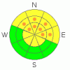
Considerable Avalanche Danger remains on above Treeline slopes facing North, Northeast and East. With more snow on the way, this rating will soon be on the low side of the actual Avalanche Danger. Extreme Caution should be used if you intend to travel in avalanche terrain above treeline. Where there is enough coverage to ski, there may be significant Avalanche Danger. Please work this conflict out in a conservative manner....
Nice cross-country skiing conditions and snowmobiling conditions exist at the moment. The Grooming program begins today in the La Sals. These may make for some safer options.
Click here to see the newly revised North American Avalanche Danger Scale. |
|
|
CURRENT CONDITIONS |

|
It looks like we picked up another 3-4 inches of snow since yesterday afternoon and there's more on the way. Yesterday we found some great powder skiing in Gold Basin but coverage is still a bit dicey. We have 29 inches of snow on the ground at the Gold Basin snow stake and only 15 at the Snotel site so keep the speed down. South and west facing slopes are still skiing nicely due to all the cold weather we've been having.
The San Juan County Road Dept. Opened up access to the East side of the La Sals via the Dark canyon trailhead Tuesday. The road to the Geyser Pass Winter Trailhead has been cleared and the road was in great shape. Thank You San Juan County. Remember that was yesterday and we've had a bit of snow so As always 4WD or Chains should be available when heading up to the mountains.
Trail grooming begins today |
|
|
RECENT ACTIVITY |

|
Soft Slab Activity noted with this storm: Mostly small pockets. Most appear to have run during the last storm.
Exxon's Folley - NN-SS-R2D2 50' x 400' upper observer's right.
Middle Cirque - The Cleavers NN-SS-R2D2 x 2 both of them.
Talking Mountain Cirque - NN-SSR2D2-O 100 x 1000' way right
Upper Horse Creek NN-SS-R2D2-G 150-1000' just at treeline
Check out more info on avalanche classification here. |
|
|
THREAT #1 |

|
| WHERE |
PROBABILITY |
SIZE |
TREND |
|
|
|
|
| |
|
|
Over the next
24 hours.
|
|
|
Click here to see the newly revised North American Avalanche Danger Scale.
The snowpack remains reactive with lot's of collapsing and whumpfing was going on. Shooting Cracks were appearing around our skis regularly. Stability tests show some of the weakest snow I've ever seen. Scared yet? You should be. The only factor that has kept the Mountains of SE Utah from completely unraveling is the lack of snow before this last storm.
Keeping Pockets of CONSIDERABLE avalanche danger in the forecast above treeline on East, Northeast and North facing slopes. Strong winds yesterday were continuing to load already tender slopes on these aspects. Expect to find a MODERATE avalanche danger elsewhere.
With more snow in the forecast expect continuing avalanche dangers in the mountains of SE Utah. |
|
|
MOUNTAIN WEATHER |

|
National Weather Service Forecast for 10,000 Ft. :
Today:
Snow. High near 19. East southeast wind 5 to 10 mph becoming south southwest. Chance of precipitation is 80%. Total daytime snow accumulation of 3 to 5 inches possible.
Tonight:
Snow. Low around 12. South southwest wind between 10 and 15 mph. Chance of precipitation is 90%. New snow accumulation of 4 to 8 inches possible.
Sunday:
Snow. High near 20. Breezy, with a south wind between 15 and 25 mph. Chance of precipitation is 90%. New snow accumulation of 5 to 9 inches possible.
Sunday Night:
Snow. Low around 9. Windy, with a southwest wind 25 to 30 mph decreasing to between 15 and 20 mph. Winds could gust as high as 45 mph. Chance of precipitation is 80%. New snow accumulation of 4 to 8 inches possible.
Monday:
A 40 percent chance of snow. Cloudy, with a high near 19. South wind between 10 and 15 mph becoming calm. |
|
|
GENERAL ANNOUNCEMENTS |
Basic Avalanche Awareness Class - Grand County Library, January 12th - 5:30 - 8:00 PM.
LSAC Level One Avalanche Class - 3 days, January 29 - 31 - Call 435-636-3363 to reserve a spot or get more info. |
|
|
This information does not apply to developed ski areas or highways where avalanche control is normally done. This advisory is from the U.S.D.A. Forest Service, which is solely responsible for its content. This advisory describes general avalanche conditions and local variations always occur. |
|
This advisory provided by the USDA Forest Service, in partnership with:
The Friends of the Utah Avalanche Center, Utah Division of State Parks and Recreation, Utah Division of Emergency Management, Salt Lake County, Salt Lake Unified Fire Authority and the friends of the La Sal Avalanche Center. See our Sponsors Page for a complete list. |
