Moab Avalanche Advisory

Forecaster: Dave Medara

BOTTOM LINE

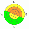
Danger by aspect and elevation on slopes approaching 35° or steeper.
(click HERE for tomorrow's danger rating)


Danger Rose Tutorial

Considerable Avalanche Danger in the Mountains of SE Utah at this time. Storm totals of 1-2 (and more!)feet have been measured through out SE Utah. Backcountry travelers should be able to recognize and avoid avalanche terrain and runout zones. Avalanches and unstable snowpack structures have been confirmed. Heads up! Bundle Up!

Click here to see the newly revised North American Avalanche Danger Scale.


CURRENT CONDITIONS

Continued very cold temperatures. -8 Degrees F in Moab, 4 Degrees F at the Geyser Pass Snotel and 0 degrees F on Pre-Laurel Peak at 8:00 AM. Bundle up if you go out today and check your partners for frostbite. The problem today is that to get anywhere that has good skiing you're going to have to expose yourself to potentially high avalanche danger and risk life and limb getting in and out of you objective. The ground cover is BAD. Max and I toured into Gold Basin in yesterday. Let's just say rock skis are mandatory!

The San Juan County Road Dept. Opened up access to the East side of the La Sals via the Dark canyon trailhead Tuesday and got part of the road to the Geyser Pass trailhead open. They didn't make it to the parking lot yet and have one lane punched up to just above the Aspens. Hopefully they'll finish it up today. 4WD and Chains are recommended.

SNOW From last storm:

7-8 inches of new snow reported in Moab. More in Castle Valley and Locations in Spanish Valley.

18" of snow @ 10,000 ft int he La Sals 1.98 h2o - Gold Basin

14" snow @ 9800' in the La Sals, 1.6" h2o - Snotel

27" snow @ 8600' in the Abajos, 3.0" h2o (!)


RECENT ACTIVITY

Class 2 (small slab) activity noted in Exxon's Folley and in the Middle cirque. Small pockety slabs releasing with terrain features not covered well. Lot's of collapsing and cracking.


THREAT #1

WHERE PROBABILITY SIZE TREND
      Over the next 24 hours.

Click here to see the newly revised North American Avalanche Danger Scale.

With 1-2 (or more!) feet of new, wind driven snow falling on a weak Faceted Grain older snowpack, we can still expect to find a Considerable Avalanche Danger above treeline on East, Northeast, and North facing slopes in the mountains of SE Utah. The danger will be more severe on, but not limited to, slopes above treeline. Above treeline yesterday there was still a lot of wind transport going on. Slopes below treeline will have varying degrees of avalanche danger depending on the amount of snow coverage before this last storm. Natural avalanches are still possible and Human triggered avalanches are likely. Travel in avalanche terrain must be done with careful analysisis of the snowpack.A limiting factor in the amount of avalanching we've seen is that small mountainside terrain features have barely been covered up. This is limiting the size development of slab from this last storm (a good thing) but the snowpack is very weak and reactive so it will still be possible to trigger these smaller pockets.


MOUNTAIN WEATHER

National Weather Service Forecast for 10,000 Ft. :

Today:

Partly sunny, with a high near 23. South southeast wind 5 to 10 mph becoming west southwest.

Tonight:

Mostly cloudy, with a low around 2. West wind around 5 mph becoming calm.

Friday:

A 20 percent chance of snow after 11am. Mostly cloudy, with a high near 21. Calm wind becoming west southwest around 5 mph.

Friday Night:

A 40 percent chance of snow. Cloudy, with a low around 11. Calm wind becoming south around 5 mph.

Saturday:

A 40 percent chance of snow. Cloudy, with a high near 22. South southwest wind between 5 and 10 mph.

Saturday Night:

Snow likely. Cloudy and breezy, with a low around 15. Chance of precipitation is 70%.

Sunday:

Snow likely. Cloudy, with a high near 20. Chance of precipitation is 70%.


GENERAL ANNOUNCEMENTS

LUNA Groomer Training December 12th - Contact Kiersten Peterson at 260-0042 if you are interested in volunteering for the Lower Utah Nordic Alliance grooming team. We'll meet at 8:00 AM at the Moab Area Arts and Recreation Center, then head up on the mountain.

Basic Avalanche Awareness Class - Grand County Library, January 12th - 5:30 - 8:00 PM.

LSAC Level One Avalanche Class - 3 days, January 29 - 31 - Call 435-636-3363 to reserve a spot or get more info.


This information does not apply to developed ski areas or highways where avalanche control is normally done.  This advisory is from the U.S.D.A. Forest Service, which is solely responsible for its content. This advisory describes general avalanche conditions and local variations always occur.


This advisory provided by the USDA Forest Service, in partnership with:

The Friends of the Utah Avalanche Center, Utah Division of State Parks and Recreation, Utah Division of Emergency Management, Salt Lake County, Salt Lake Unified Fire Authority and the friends of the La Sal Avalanche Center. See our Sponsors Page for a complete list.