AVALANCHE WARNING »
Dangerous avalanche conditions are occuring or are imminent.
Backcountry travel in avalanche terrain is not recommended.
|
 |
Notice: Dangerous avalanche conditions are occurring or are imminent.
Backcountry travel in avalanche terrain is not recommended.
THE LA SAL AVALANCHE CENTER HAS ISSUED AN AVALANCHE WARNING IS FOR THE MOUNTAINS OF SOUTHEASTERN UTAH INCLUDING THE LA SAL AND ABAJO MOUNTAINS
UP TO 2 FEET OF NEW SNOW COMBINED WITH STRONG WINDS HAS OVERLOADED BURIED
LAYERS OF VERY WEAK SNOW NEAR THE GROUND, CREATING LARGE AND VERY
DANGEROUS AVALANCHES. BACKCOUNTRY TRAVELERS SHOULD STAY OFF OF AND
OUT FROM UNDERNEATH ANY SLOPE STEEPER THAN ABOUT 30 DEGREES.
LINGERING AVALANCHE DANGER MAY PERSIST THROUGH THE WEEK. |
|
|
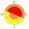
BOTTOM LINE
Danger by aspect and elevation on slopes approaching 35° or steeper.
(click HERE for tomorrow's danger rating)
|

Danger Rose Tutorial
|
High Avalanche Danger in the Mountains of SE Utah at this time. Storm totals of 1-2 feet are being reported with more on the way. Backcountry travelers should be able to recognize and avoid avalanche terrain and runout zones. Bundle Up!
Click here to see the newly revised North American Avalanche Danger Scale. |
|
|
CURRENT CONDITIONS |

|
Very Cold Temperatures are the morning weather headline. 3 Degrees F in Moab, -5 Degrees F at the Geyser Pass Snotel and -12 degrees F on Pre-Laurel Peak. Bundle up if you go out today and check your partners for frostbite. There should be some fine powder skiing and riding in the mountains of SE Utah, but be careful of thin ground cover and continuing avalanche danger. It goes without saying that snow conditions in SE Utah will be improving. Right now the problem will be access, followed by safety once access is gained. Be careful out there and stay off of, and out from under, slopes steeper than 30 degrees.
The San Juan County Road Dept. Opened up access to the East side of the La Sals via the Dark canyon trailhead yesterday and the road foreman says they'll get to the Geyser Pass road and lot today. If you get up there before the plows, 4WD and Chains are recommended. We'll be running them this morning.
SNOW TOTALS SO FAR:
7-8 inches of new snow reported in Moab. More in Castle Valley and Locations in Spanish Valley.
14" snow @ 9800' in the La Sals, 1.6" h2o
27" snow @ 8600' in the Abajos, 3.0" h2o (!) |
|
|
RECENT ACTIVITY |

|
None reported or observed. Yet. Expect things to get wild above treeline. Hopefully we'll have visibility today. There has been a lot of avalanche activity in the San Juans, both natural and with control work. |
|
|
THREAT #1 |

|
| WHERE |
PROBABILITY |
SIZE |
TREND |
|
|
|
|
| |
|
|
Over the next
48 hours.
|
|
|
Click here to see the newly revised North American Avalanche Danger Scale.
With 1-2 (or more!) feet of new, wind driven snow falling on a weak Faceted Grain older snowpack, we can still expect to find a HIGH Avalanche Danger above treeline on East, Northeast, and North facing slopes in the mountains of SE Utah. The danger will be more severe on, but not limited to, slopes above treeline. Slopes below treeline will have varying degrees of avalanche danger depending on the amount of snow coverage before this last storm. Natural and Human triggered avalanches are likely. Travel in avalanche terrain is not recommended. |
|
|
MOUNTAIN WEATHER |

|
National Weather Service Forecast for 10,000 Ft. :
Another significant surge of Pacific moisture is forecast to hit our region over the weekend. Highlights to emerge as we get closer to the event.
Today: A 20 percent chance of snow. Mostly cloudy, with a high near 14. Wind chill values as low as -20. Southwest wind between 10 and 15 mph. Tonight: A 20 percent chance of snow. Mostly cloudy, with a low around 3. South southeast wind between 5 and 10 mph becoming calm. Thursday: Cloudy, with a high near 25. South wind around 5 mph becoming west. Thursday Night: Mostly cloudy, with a low around 10. South wind around 15 mph. Friday: A 20 percent chance of snow. Cloudy, with a high near 22. South southeast wind around 10 mph becoming west. Friday Night: A 30 percent chance of snow. Cloudy, with a low around 12. Saturday: A 40 percent chance of snow. Cloudy, with a high near 22. |
|
|
GENERAL ANNOUNCEMENTS |
LUNA Groomer Training December 12th - Contact Kiersten Peterson at 260-0042 if you are interested in volunteering for the Lower Utah Nordic Alliance grooming team. We'll meet at 8:00 AM at the Moab Area Arts and Recreation Center, then head up on the mountain.
Basic Avalanche Awareness Class - Grand County Library, January 12th - 5:30 - 8:00 PM.
LSAC Level One Avalanche Class - 3 days, January 29 - 31 - Call 435-636-3363 to reserve a spot or get more info. |
|
|
This information does not apply to developed ski areas or highways where avalanche control is normally done. This advisory is from the U.S.D.A. Forest Service, which is solely responsible for its content. This advisory describes general avalanche conditions and local variations always occur. |
|
This advisory provided by the USDA Forest Service, in partnership with:
The Friends of the Utah Avalanche Center, Utah Division of State Parks and Recreation, Utah Division of Emergency Management, Salt Lake County, Salt Lake Unified Fire Authority and the friends of the La Sal Avalanche Center. See our Sponsors Page for a complete list. |
