SPECIAL ANNOUNCEMENT |
 |
Good Afternoon and welcome to the start of the 2009-2010 snow and avalanche season on the Manti-La Sal National Forest. We'll be issuing forecasts Monday, Wed/Thurs. and Friday with more frequent updates during storms or rapidly changing conditions. Pray for snow! |
|
|
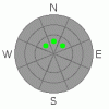
BOTTOM LINE
Danger by aspect and elevation on slopes approaching 35° or steeper.
(click HERE for tomorrow's danger rating)
|

Danger Rose Tutorial
|
Low Avalanche Danger in the Mountains of SE Utah. Not much snow so be careful if you do venture out into the winter backcountry. No snow in the forecast until Sunday night. |
|
|
CURRENT CONDITIONS |

|
Snow on North facing and Shady terrain above about 9500'. Not enough yet for backcountry skiing and riding.
Cross Country skiing is possible on the roads, but no grooming has begun yet. It's pretty rough from vehicles too.
Avalanche danger LOW on upper elevation N. facing slopes and non-existent on other slopes.
The Geyser Pass Road and the La Sal Loop road are open and passable but expect some icy sections. |
|
|
RECENT ACTIVITY |

|
none reported or observed. |
|
|
THREAT #1 |

|
| WHERE |
PROBABILITY |
SIZE |
TREND |
|
|
|
|
| |
|
|
Over the next
48 hours.
|
|
|
Low avalanche danger as of 12/01/09. Very limited snow coverage. Pockets of wind slab may exist on upper elevation, wind affected slopes on North and Northeast facing slopes above treeline.
This forecast will EXPIRE in 48 hours. |
|
|
MOUNTAIN WEATHER |

|
National Weather Service Forecast for 10,000 Ft. : CHILLY!
Tonight: Partly cloudy, with a low around 1. Wind chill values as low as -10. North northwest wind around 10 mph.
Thursday: Partly sunny, with a high near 12. Wind chill values as low as -10. North northwest wind between 10 and 15 mph.
Thursday Night: Partly cloudy, with a low around -2. Wind chill values as low as -20. North wind 10 to 15 mph becoming west.
Friday: Mostly sunny, with a high near 17. Wind chill values as low as -10. North wind between 5 and 10 mph.
Friday Night: Mostly clear, with a low around 5. West southwest wind around 5 mph becoming southeast.
Saturday: Mostly sunny, with a high near 29.
Saturday Night: A 20 percent chance of snow. Cloudy, with a low around 8.
Sunday: A chance of snow. Cloudy, with a high near 19.
Sunday Night: A slight chance of snow. Cloudy, with a low around 9.
Monday: Snow likely. Cloudy, with a high near 20.
Monday Night: Snow likely. Cloudy, with a low around 13.
Tuesday: Snow likely. Cloudy, with a high near 21. |
|
|
GENERAL ANNOUNCEMENTS |
LUNA Groomer Training December 12th - Contact Kiersten Peterson at 260-0042 if you are interested in volunteering for the Lower Utah Nordic Alliance grooming team.
Basic Avalanche Awareness Class - Grand County Library, January 12th - 5:30 - 8:00 PM.
LSAC Level One Avalanche Class - 3 days, January 29 - 31 - Call 435-636-3363 to reserve a spot or get more info. |
|
|
This information does not apply to developed ski areas or highways where avalanche control is normally done. This advisory is from the U.S.D.A. Forest Service, which is solely responsible for its content. This advisory describes general avalanche conditions and local variations always occur. |
|
This advisory provided by the USDA Forest Service, in partnership with:
The Friends of the Utah Avalanche Center, Utah Division of State Parks and Recreation, Utah Division of Emergency Management, Salt Lake County, Salt Lake Unified Fire Authority and the friends of the La Sal Avalanche Center. See our Sponsors Page for a complete list. |
