SPECIAL ANNOUNCEMENT |
 |
Our last forecast for the season will be Saturday April 5th, 2009 |
|
|
BOTTOM LINE
Danger by aspect and elevation on slopes approaching 35° or steeper.
(click HERE for tomorrow's danger rating)
|
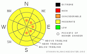
Danger Rose Tutorial
|
Mostly MODERATE avalanche danger, with pockets of CONSIDERABLE due to wild winds from many points of the compass above treeline. Good powder conditions on mid-elevation shady side slopes. Sunny side slopes got enough sun today to put a crust on them. |
|
|
CURRENT CONDITIONS |

|
Snowy and cold conditions have been in force with winter's strong return at high (and low!) elevations. We've had 8 inches of new snow this week and moderate cloud cover and cold temperatures will work together to preserve winter (dry) snow conditions on E-NE-NW facing slopes. There was enough sun and warm temperatures today to wreck the powder skiing on South facing slopes and cap below treeline slopes with a bit of zipper crust. North facing slopes will be a mish-mash of conditions, especially above treeline where winds have been busy. Plumes were visible from town today as winds from the north did their best to move around the new snow. Expect questionable bonds between the new snow and the dirty dusty old snow surface from last Sunday/Monday's wind event if you venture into the high country. There should be some good skiing and riding out there if you venture onto mid elevation shady side slopes but don't discount the avalanche danger. We have 60 inches of snow at the Gold Basin Study plot and we're at 74% of normal snowpack at the moment |
|
|
RECENT ACTIVITY |

|
none reported. |
|
|
THREAT #1 |

|
| WHERE |
PROBABILITY |
SIZE |
TREND |
|
|
|
|
| |
|
|
Over the next
24 hours.
|
|
|
Link to the U.S. Avalanche danger scale here: utahavalanchecenter.org/education/dangerscale
Winter has returned to the mounains. Expect to find a MODERATE avalanche danger in the mountains of SE Utah right now after the fresh snow we've had. Winds have been moving a lot of snow around causing loading and drifting. Watch for cross loaded slopes as winds have spun around the compass from Southwesterly to now Nothwesterly via the eastern cardinal points. Expect variable conditions and variable avalanche dangers up high, winds have been busy so it's hardly green light conditions in the Alpine Zone. Questionable bonds between the old and new snow exist due to dirt and dust the blew into the mountains last Sunday. We are calling the avalanche danger MODERATE, with pockets of CONSIDERABLE above treeline on S-E-N facing slopes. |
|
|
MOUNTAIN WEATHER |

|
Mountain Weather for SE Utah at 10,000 ft:
Overnight: Partly cloudy, with a low around 13. Northeast wind around 5 mph becoming calm. Saturday: Mostly sunny, with a high near 36. Calm wind becoming northwest around 5 mph. Saturday Night: Mostly cloudy, with a low around 22. West northwest wind 5 to 10 mph becoming southeast. Sunday: A 50 percent chance of snow showers after noon. Areas of blowing dust after noon. Mostly cloudy, with a high near 42. Windy, with a south southwest wind 15 to 20 mph increasing to between 30 and 35 mph. Winds could gust as high as 60 mph. New snow accumulation of less than a half inch possible. Sunday Night: A 40 percent chance of snow. Mostly cloudy, with a low around 12. Windy, with a northwest wind 25 to 30 mph decreasing to between 5 and 10 mph. Winds could gust as high as 55 mph. Monday: Mostly sunny, with a high near 27. Monday Night: Mostly cloudy, with a low around 11. Tuesday: A slight chance of snow. Mostly cloudy, with a high near 33. |
|
|
GENERAL ANNOUNCEMENTS |
This forecast will expire in 24 hours. |
|
|
This information does not apply to developed ski areas or highways where avalanche control is normally done. This advisory is from the U.S.D.A. Forest Service, which is solely responsible for its content. This advisory describes general avalanche conditions and local variations always occur. |
|
This advisory provided by the USDA Forest Service, in partnership with:
The Friends of the Utah Avalanche Center, Utah Division of State Parks and Recreation, Utah Division of Emergency Management, Salt Lake County, Salt Lake Unified Fire Authority and the friends of the La Sal Avalanche Center. See our Sponsors Page for a complete list. |
