SPECIAL ANNOUNCEMENT |
 |
The Avalanche Danger Scale is being revised for next winter. Our friends up in Canada have created a short survey found at the following link. Please help ensure the new Avalanche Danger Scale is effective by completing a survey. http://surveys.globalepanel.com/wix/p319164581.aspx |
|
|
BOTTOM LINE
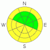
Danger by aspect and elevation on slopes approaching 35° or steeper.
(click HERE for tomorrow's danger rating)
|
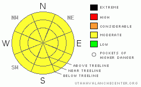
Danger Rose Tutorial
|
Powder Skiing and Riding conditions are still good in many areas of the SE Utah mountains. Mid-elevation E-NE-NW facing slopes are reportedly good skiing at the moment. Avoid wind loaded areas, particlarly above treeline. Avalanche Danger rating MODERATE, meaning the possibility of human triggered avalanches still exists in isolated areas. |
|
|
CURRENT CONDITIONS |

|
Things are calming down a bit in the La Sals. Spring weather, although cool, has provided abundant sunshine to the Peaks of SE Utah and the strong sun this time of year has heated up and crusted over the sunny side slopes on SE-SW-W facing slopes. This will reduce the Avalanche Danger on these aspects and put a damper on any good skiing and riding conditions until we get a couple of more days of melt-freeze cycles. Good conditions can be found on shady side slopes, E-NE-NW facing, especially at mid elevations below treeline. We continue to hover around 100% of normal snowpack in the La Sals and about 90% in the Abajos. Clouds are just starting to move over the Moab Valley and the La Sals this morning and more snow may be on the way but it doesn't sound like a big storm.
The road to the Geyser Pass trailhead and the Dark Canyon trailhead has been plowed.
There has not yet been any grooming done since the new snow. |
|
|
RECENT ACTIVITY |

|
Snowpack has been well behaved since last Sunday. |
|
|
THREAT #1 |

|
| WHERE |
PROBABILITY |
SIZE |
TREND |

|
|
|
|
| |
|
|
Over the next
24 hours.
|
|
|
Link to the U.S. Avalanche danger scale here: utahavalanchecenter.org/education/dangerscale
Solar radiation from the last two days of sunshine has dropped the Avalanche Danger to Low on SE-SW-W facing slopes where they remain crusted over. Expect to find a MODERATE Avalanche Danger on the shady side slopes E-NE-NW facing, where better conditions for skiing and riding will be found. Things have been relatively calm avalanche wise since this last storm, but we have had 2 feet of snow since last Friday and copious winds earlier this weak that have scoured some slopes, and loaded others. Approach wind loaded slopes with extreme caution. Remember to ski or high mark one at a time and stay clear avalanche paths and runout zones after your run. |
|
|
THREAT #2 |

|
| WHERE |
PROBABILITY |
SIZE |
TREND |
|
|
|
|
| |
|
|
Over the next
8 hours.
|
|
|
Watch daytime heating today with forecast warm temperatures. If the slope you are on is getting wet and mushy, and crusts that were frozen earlier in the day have melted off, then it is time to get out of there. |
|
|
MOUNTAIN WEATHER |

|
Mountain Weather for SE Utah at 10,000 ft: Chance of snow through the weekend
Today: A 30 percent chance of snow. Mostly cloudy, with a high near 40. South wind around 5 mph becoming west northwest. Winds could gust as high as 20 mph. Tonight: A 30 percent chance of snow. Mostly cloudy, with a low around 21. North northeast wind between 5 and 10 mph, with gusts as high as 25 mph. Friday: A 40 percent chance of snow. Mostly cloudy, with a high near 35. North northeast wind between 5 and 15 mph, with gusts as high as 30 mph. Friday Night: A 20 percent chance of snow. Mostly cloudy, with a low around 21. Northeast wind 5 to 15 mph becoming southwest. Winds could gust as high as 30 mph. Saturday: A 20 percent chance of snow. Mostly cloudy, with a high near 36. Southwest wind between 5 and 10 mph. Saturday Night: A 30 percent chance of snow. Mostly cloudy and breezy, with a low around 24. Sunday: A 30 percent chance of snow. Mostly cloudy, with a high near 34. Sunday Night: Mostly cloudy, with a low around 25. Monday: Sunny, with a high near 43. |
|
|
GENERAL ANNOUNCEMENTS |
This forecast will expire in 24 hours. |
|
|
This information does not apply to developed ski areas or highways where avalanche control is normally done. This advisory is from the U.S.D.A. Forest Service, which is solely responsible for its content. This advisory describes general avalanche conditions and local variations always occur. |
|
This advisory provided by the USDA Forest Service, in partnership with:
The Friends of the Utah Avalanche Center, Utah Division of State Parks and Recreation, Utah Division of Emergency Management, Salt Lake County, Salt Lake Unified Fire Authority and the friends of the La Sal Avalanche Center. See our Sponsors Page for a complete list. |
