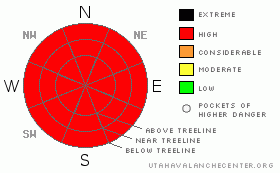
BOTTOM LINE
Danger by aspect and elevation on slopes approaching 35° or steeper.
(click HERE for tomorrow's danger rating)
|
Danger Rose Tutorial
|
Lot's of new snow. There will be good conditions for riding and skiing if you can get up there. Expect some wind affected snow. Keep the slope angles down. HIGH avalanche danger. |
|
|
CURRENT CONDITIONS |

|
Expect deep thick powder today and High avalanche danger. This one is simple. Abundant SW winds will up the avalanche danger above treeline and on E-NE-NW slopes or on any slopes that have been cross-loaded. This one is a no brainer folks. It dumped, it blew. Expect avalanches. The snotel site is showing 10" of new snow @ .9"of h2o. At 9% density with wind, this stuff will be pretty thick and heavy. Snotel measurements tend to be on the low side. More info when we can get up there.
San Juan County has a plow heading to the trailheads on the East (Dark Canyon) and the West (Geyser Pass) sides of the mountain. Expect very challenging 4wd conditions if you get up there before the equipment.
Full nordic track was groomed for classic and skate skiing. Not any more. |
|
|
RECENT ACTIVITY |

|
Point release activity, small skier release reported with daytime heating from Sunday 03/08 |
|
|
THREAT #1 |

|
| WHERE |
PROBABILITY |
SIZE |
TREND |

|
|
|
|
| |
|
|
Over the next
24 hours.
|
|
|
Link to the U.S. Avalanche danger scale here: utahavalanchecenter.org/education/dangerscale
With 10" of new, dense snow and lot's of SW winds this one will be easy. Expect a HIGH avalanche danger in the Mountains of SE Utah at this time including the La Sal and Abajo Mountains. |
|
|
MOUNTAIN WEATHER |

|
Mountain Weather for SE Utah at 10,000 ft:
Today: A 50 percent chance of snow, mainly before noon. Mostly cloudy, with a high near 27. Breezy, with a west wind between 10 and 20 mph, with gusts as high as 35 mph. Total daytime snow accumulation of less than one inch possible. Tonight: Mostly clear, with a low around 13. West wind around 5 mph becoming east southeast. Wednesday: Sunny, with a high near 33. North northwest wind around 10 mph. Wednesday Night: Partly cloudy, with a low around 21. Northwest wind around 5 mph becoming east. Thursday: A 30 percent chance of snow, mainly after noon. Mostly cloudy, with a high near 34. South southeast wind between 10 and 15 mph. Thursday Night: A 30 percent chance of snow. Mostly cloudy, with a low around 19. Friday: A 40 percent chance of snow. Mostly cloudy, with a high near 33. |
|
|
GENERAL ANNOUNCEMENTS |
This forecast will expire in 24 hours. |
|
|
This information does not apply to developed ski areas or highways where avalanche control is normally done. This advisory is from the U.S.D.A. Forest Service, which is solely responsible for its content. This advisory describes general avalanche conditions and local variations always occur. |
|
This advisory provided by the USDA Forest Service, in partnership with:
The Friends of the Utah Avalanche Center, Utah Division of State Parks and Recreation, Utah Division of Emergency Management, Salt Lake County, Salt Lake Unified Fire Authority and the friends of the La Sal Avalanche Center. See our Sponsors Page for a complete list. |
