BOTTOM LINE
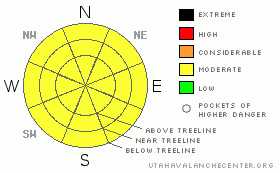
Danger by aspect and elevation on slopes approaching 35° or steeper.
(click HERE for tomorrow's danger rating)
|
Danger Rose Tutorial
|
Spring conditions.LOW to MODERATE avalanche danger with new snow capped by unusual high altitude rains. Refrozen rain/rime crust is providing good skiing conditions on Sunny slopes. MODERATE avalanche danger with daytime heating expected this weekend. Wildcard snowpack with new snow instantly capped by rain/rime crust. Unusual layering and timing for the formation of the crust covering nearly the entire SE Utah snow at the moment. Not to be entirely trusted. |
|
|
CURRENT CONDITIONS |

|
For all the new snow we picked up earlier this week, powder snow is not in the cards. Rain and Rime up to almost 12,000 feet have capped everything (ALL ASPECTS) with a 1.5 - 4 inch thick crust. Evidence of rain in lower meadows snowfields is an unusual visual scene in our mountains. The rain crust has had the effect of accelerating spring conditions. Supportable crusts on the sunny aspects are providing "instant corn" skiing We're holding steady at just over 100% of normal snowpack in the La Sals and the Abajos with about 51" at our Gold Basin Study plot.
Roads are plowed into the Geyser Pass Trailhead and the East side Trailheads.
Luna voluteers headed up Friday to do the Upper Nordic Loops and clean up what has already been done. The entire cross-country ski course is complete as of Friday afternoon. Good job groomers! |
|
|
RECENT ACTIVITY |

|
Class II Avalanche noted in Red Snow cirque Between Mt. Tukunikivatz and Tukno. This is the third time avalanches have been noted in this area this season. This must have happened Monday before the rain re-froze and locked everything in place. |
|
|
THREAT #1 |

|
| WHERE |
PROBABILITY |
SIZE |
TREND |

|
|
|
|
| |
|
|
Over the next
48 hours.
|
|
|
Link to the U.S. Avalanche danger scale here: utahavalanchecenter.org/education/dangerscale
In an unusual winter rain event (hard to believe but it is still February!) we've had rain up to at least 11,500 feet in the La Sals and everything has been capped by a stout and mostly supportable crust. While not making for any decent winter conditions (don't expect powder...) spring arrived literally overnight and corn conditions are good at the moment. This has eliminated much of the avalanche hazard in the mountains of SE Utah with the exception of afternoon wet slides this weekend when things warm up.
We are calling the avalanche danger in the La Sal Mountains LOW while crusts are still frozen, Rising to MODERATE with daytime warming and the thawing of surface crusts. With calm winds and temps in the 40's this weekend, we can expect the warm-up to be substantial. Don't let the temptation of another awesome corn run keep you out on the sunny side slopes too long. |
|
|
THREAT #2 |

|
| WHERE |
PROBABILITY |
SIZE |
TREND |

|
|
|
|
| |
|
|
Over the next
24 hours.
|
|
|
We've had an unusual event with 10" of snow (more in places) getting capped by rain and rime up to at least 11,700 ft. This is a stout crust with new snow underneath it and a highly layered, and in some places weak, underlying snowpack. In many shady areas there were near surface faceted grains developing before the last storm. Warm temps have helped the new snow bond to the old this week but no matter how you look at it, our snowpack situation right now - due to high altitude re-frozen rain - is very unusual.
An old friend of mine from Park City and an avalanche veteran of 30 years, summed it up pretty well today when I told him about what was going on here in SE Utah. "Dave", he said, "wierd storms make for wierd avalanches". While crusts like this usually add strength to the snowpack, they usually develop over time with many days of melt-freeze cycling to help heal the tender spots. This change is sudden, weight has been added to the snowpack, and with the relatively untested nature of this snowpack structure, I just can't trust it. PLUS>this is the La Sals, The International Center for Snow Strangeness. If you're out beyond morning corn skiing, or on shady side terrain, travel well away from avalanche zones. Very unscientific I know, but sometimes you just have to trust your gut. Creme' Brulee anyone? |
|
|
MOUNTAIN WEATHER |

|
Mountain Weather for SE Utah at 10,000 ft:
Tonight: Partly cloudy, with a low around 11. East southeast wind around 5 mph. Saturday: Mostly sunny, with a high near 40. East southeast wind around 5 mph becoming calm. Winds could gust as high as 20 mph. Saturday Night: Partly cloudy, with a low around 25. North wind around 5 mph becoming southeast. Winds could gust as high as 25 mph. Sunday: Partly sunny, with a high near 47. South wind between 5 and 10 mph, with gusts as high as 20 mph. Sunday Night: Mostly cloudy, with a low around 24. Breezy, with a southwest wind 5 to 10 mph increasing to between 20 and 25 mph. Monday: Mostly cloudy and breezy, with a high near 47. Monday Night: Mostly cloudy, with a low around 26. Tuesday: Mostly cloudy, with a high near 40. |
|
|
GENERAL ANNOUNCEMENTS |
Lost at Geyser Pass Trailhead. Black Life Link ski poles with red baskets. If found please call 435-636-3363
We'll update this forecast by Monday morning. |
|
|
This information does not apply to developed ski areas or highways where avalanche control is normally done. This advisory is from the U.S.D.A. Forest Service, which is solely responsible for its content. This advisory describes general avalanche conditions and local variations always occur. |
|
This advisory provided by the USDA Forest Service, in partnership with:
The Friends of the Utah Avalanche Center, Utah Division of State Parks and Recreation, Utah Division of Emergency Management, Salt Lake County, Salt Lake Unified Fire Authority and the friends of the La Sal Avalanche Center. See our Sponsors Page for a complete list. |
