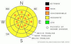
BOTTOM LINE
Danger by aspect and elevation on slopes approaching 35° or steeper.
(click HERE for tomorrow's danger rating)
|

Danger Rose Tutorial
|
New wet snow with inverted conditions and some sort of crusty depostion at the surface are being reported. May be best to let this stuff settle out for both ski conditions and avalanche hazard. MODERATE danger with pockets of CONSIDERABLE up high at and above treeline. Rock Climbing anyone? |
|
|
CURRENT CONDITIONS |

|
New snow, more than forecast has graced the mountains of SE Utah with it's presence. Thank you. The La Sals picked up 1.2 inches of water with 8" of snow being measured at Gold Basin. 10 inches or more re being reported around 11,000 ft. The Abajos picked up about half that. Being springtime and all this stuff was thick, and unfortunately, it came in heavier at the end of the storm leaving behind variable skiing and riding conditions. Sounds like South faces with limited new snow coverage are the best bet, with corn like conditions being reported in the SE facing bowl under Mann's Peak. Winds probably stripped the bowl leaving a supportable base that softened up nicely yesterday.
Roads are plowed into the Geyser Pass Trailhead and the East side Trailheads.
LUNA groomed into Geyser Pass Road, Gold Basin and the Lower and Upper Nordic loops are groomed. Good job Drake and Helen |
|
|
RECENT ACTIVITY |

|
Nothing Noted. |
|
|
THREAT #1 |

|
| WHERE |
PROBABILITY |
SIZE |
TREND |

|
|
|
|
| |
|
|
Over the next
48 hours.
|
|
|
Link to the U.S. Avalanche danger scale here: utahavalanchecenter.org/education/dangerscale
1.2 inches of new water weight with south winds. Collapsing and whoompfing of weak old snow structures are still being reported. While no avalanches have been reported, these alone are two major red flags indicating instability in the snowpack. With warm temps and heavy snow this instability will not last long but give it a chance to settle out. We DO have buried weak layers in the snowpack (surface hoar, buried near surface facets) and these appear to be a bit noisy still, so best to stay off the big north facing shots. We are calling the avalanche danger MODERATE with pockets of CONSIDERABLEat and above treeline on E-NE-NW facing slopes and above treeline onthe sunny side slopes where cross loading from South winds may be a factor. |
|
|
THREAT #2 |

|
| WHERE |
PROBABILITY |
SIZE |
TREND |

|
|
|
|
| |
|
|
Over the next
8 hours.
|
|
|
Watch for afternoon wet slides at lower elevations on the sunny side slopes. Winds today will help mellow out this problem, but the temperatures are still expected to be quite warm. Loose wet slides and potentially larger wet slabs are possible in the afternoon after things warm up. Expect the hazard posed by these glop-monsters to be greatly increased IF we do not have a freeze overnight.Get off wet slopes when you start to see rollerballs or point releases from rocks, trees and other warm spots. |
|
|
MOUNTAIN WEATHER |

|
Mountain Weather for SE Utah at 10,000 ft:
Today: Mostly cloudy, with a high near 42. South wind between 10 and 15 mph, with gusts as high as 35 mph. Tonight: A 20 percent chance of snow. Mostly cloudy, with a low around 26. Southwest wind between 5 and 15 mph, with gusts as high as 35 mph. Thursday: A 20 percent chance of snow. Mostly cloudy, with a high near 35. Calm wind becoming west southwest between 10 and 15 mph. Winds could gust as high as 30 mph. Thursday Night: A 20 percent chance of snow. Mostly cloudy, with a low around 22. West southwest wind between 5 and 15 mph, with gusts as high as 30 mph. Friday: A 30 percent chance of snow. Mostly cloudy, with a high near 34. Southwest wind between 5 and 15 mph. Friday Night: A 30 percent chance of snow. Mostly cloudy, with a low around 18. Saturday: Mostly sunny, with a high near 35. Saturday Night: Partly cloudy, with a low around 23. Sunday: Mostly cloudy, with a high near 41. |
|
|
GENERAL ANNOUNCEMENTS |
Lost at Geyser Pass Trailhead. Black Life LInk ski poles with red baskets. If found please call 435-636-3363
We'll update this forecast by Saturday morning. |
|
|
This information does not apply to developed ski areas or highways where avalanche control is normally done. This advisory is from the U.S.D.A. Forest Service, which is solely responsible for its content. This advisory describes general avalanche conditions and local variations always occur. |
|
This advisory provided by the USDA Forest Service, in partnership with:
The Friends of the Utah Avalanche Center, Utah Division of State Parks and Recreation, Utah Division of Emergency Management, Salt Lake County, Salt Lake Unified Fire Authority and the friends of the La Sal Avalanche Center. See our Sponsors Page for a complete list. |


