SPECIAL ANNOUNCEMENT |
 |
OKthis is ridiculous. Don't block the road at the sled hill. Keep your belongings and car doors out of the travel lanes. It's a road, not your living room. I can't believe I have to say this. The Forest Service has had many complaints, and THE AREA AT THE BOTTOM OF THE SLED HILL MAY BE CLOSED TO PARKING IF INCIDENTS THERE CONTINUE. Don't blow it. Tell someone else and get this area sorted. |
|
|
BOTTOM LINE
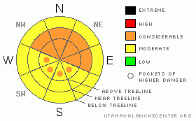
Danger by aspect and elevation on slopes approaching 35° or steeper.
(click HERE for tomorrow's danger rating)
|
Danger Rose Tutorial
|
Great conditions, best of the year, continue in SE Utah. Winds were up fri/sat from the south so lee (downwind) aspects, E-NE-NW, are not to be attacked without some inspection. Dig a pit. Hammer a test slope. Above treeline the avalanche danger is CONSIDERABLE. Expect MODERATE avalanche danger to be found below treeline but make and effort to see what the wind and snowpack are like where YOU are. |
|
|
CURRENT CONDITIONS |

|
Another 2" at the Gold Basin Study plot Since Friday night. 21" since last Sunday. Snow forecast for Saturday night and yesterday never materialized but Great skiing and Riding condition are still happening in SE Utah nonetheless. It really is very good right now. The winds did come up late Friday and into Saturday from the south so there is some wind damage and increased avalanche danger up high. As one touring party said today "things are a little sketchy up high". Sunny side slopes probably took some damage today so think shady.
The Road to the Geyser Pass Traihead and Dark Canyon are currently NOT plowed. There was enough traffic on the Geyser Pass Road this weekend so far that it is passable by most vehicles. Not so for the East side access yet.
LUNA groomed in to Gold Basin and the Lower Nordic Loops Friday too. The 2-3 inches of new snow that fell since the grooming was done on Friday didn't mess things up too bad .There is some excellent "powder skating" and classic skiing on the groomage. |
|
|
RECENT ACTIVITY |

|
Lot's of class 1 point release activity in GOLD BASIN noted of late, but nothing significant.
If you see an avalanche, experience a collapse or a whumpf, have anything interesting to pass on, or just want to spray about the ski conditions, let us know here. ANYobservations are very helpful. |
|
|
THREAT #1 |

|
| WHERE |
PROBABILITY |
SIZE |
TREND |
|
|
|
|
| |
|
|
Over the next
48 hours.
|
|
|
Link to the U.S. Avalanche danger scale here: utahavalanchecenter.org/education/dangerscale
The Avalanche Danger Rating is still not changing too much. With lot's of storm snow to move around, winds continue to be the dominant theme in the avalanche equation right now. South Winds came up Friday/Sat, moving around the light density snow laying on the ground. Loading/Cross loading downwind slopes. With higher Relative Humidity levels (no sublimation = more transport) this is the number one factor to keep and eye on right now.
We are calling the Avalanche Danger CONSIDERABLE on all slopes near and above treeline, steeper than 30 degreees on E - NE - NW aspects. Expect to find pockets of CONSIDERABLE danger on SE-SW-W facing slopes above treeline where cross-loads from fri/sat winds are a possibility. Below treeline we are calling the avalanche danger MODERATE, but, see below, and watch for what the winds have done exactly where you are. If it looks fat, it probably is. |
|
|
THREAT #2 |

|
| WHERE |
PROBABILITY |
SIZE |
TREND |
|
|
|
|
| |
|
|
Over the next
48 hours.
|
|
|
Lingering persistent slab possibilities have re-surfaced with this storm cycle. Thinner snowpack areas where the mid-pack has been broken down into sugary crystals are not to be trusted completely. Areas holding less than three feet or so of snow are particularly suspect. Collapsing and Whoopfing are still being reported as of Sunday. Some of these areas are really rotten. If you can poke your pole to the ground easily in a thin snowpack area, you'll know what I'm talking about. Lower and Mid-elevation areas that didn't have the snow coverage before this storm are to be approached with extra caution. Likelihood of triggering an avalanche like this are low to ???, but the consequences of getting caught in one could be serious. These slabs could go to the ground. This would include areas such as Corkscrew Glades or Colorado Bowl. |
|
|
MOUNTAIN WEATHER |

|
Mountain Weather for SE Utah at 10,000 ft: More snow on the way...still
Presidents' Day: A 30 percent chance of snow showers, mainly after 11am. Mostly cloudy, with a high near 32. Breezy, with a south wind between 10 and 20 mph, with gusts as high as 30 mph.
Tonight: Snow. Low around 18. Breezy, with a south southwest wind between 15 and 20 mph, with gusts as high as 35 mph. Chance of precipitation is 90%. New snow accumulation of 2 to 4 inches possible.
Tuesday: Snow and areas of blowing snow. High near 23. Breezy, with a west southwest wind between 15 and 20 mph, with gusts as high as 35 mph. Chance of precipitation is 90%. New snow accumulation of 3 to 5 inches possible.
Tuesday Night: Snow, mainly before 11pm. Low around 11. Breezy, with a west southwest wind 15 to 20 mph decreasing to between 5 and 10 mph. Winds could gust as high as 30 mph. Chance of precipitation is 80%. New snow accumulation of 2 to 4 inches possible.
Wednesday: A 50 percent chance of snow. Mostly cloudy, with a high near 22. West southwest wind around 10 mph.
Wednesday Night: Mostly cloudy, with a low around 12. |
|
|
This information does not apply to developed ski areas or highways where avalanche control is normally done. This advisory is from the U.S.D.A. Forest Service, which is solely responsible for its content. This advisory describes general avalanche conditions and local variations always occur. |
|
This advisory provided by the USDA Forest Service, in partnership with:
The Friends of the Utah Avalanche Center, Utah Division of State Parks and Recreation, Utah Division of Emergency Management, Salt Lake County, Salt Lake Unified Fire Authority and the friends of the La Sal Avalanche Center. See our Sponsors Page for a complete list. |
