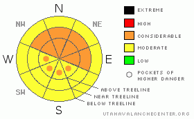
BOTTOM LINE
Danger by aspect and elevation on slopes approaching 35° or steeper.
(click HERE for tomorrow's danger rating)
|
Danger Rose Tutorial
|
Best Conditions of the year at the moment with increasing avalanche dangers due to rising south winds. Lee aspects, E-NE-NW, suspect at and above treeline where avalanche danger is CONSIDERABLE.
Winds will be a major player in the avalanche equation today so as always, travel with extreme caution in the mountains of SE Utah. |
|
|
CURRENT CONDITIONS |

|
It looks like we've picked up another inch last night bringing out total since Sunday to 20" of new snow. Not bad for the La Sals and it fell with decreasing density, making for some epic ski conditions. That will have changed a bit in the Alpine zone, near and above treeline as the winds have come back up and we're looking at a lot of wind slab development with all the new snow available for transport. AS usual mid and lower elevation E-NE-NW facing slopes are going to be your best bet for good conditions.
The Road to the Geyser Pass Traihead and Dark Canyon are currently NOT plowed. We'll get you an update as soon as I can speak to the road foreman, who's out of town. The Geyser Road is passable with 4WD and it's not too bad as it saw a lot of traffic Friday.
LUNA groomed in to Gold Basin and the Lower Nordic Loops Friday too. |
|
|
RECENT ACTIVITY |

|
Some class II avi's with Sunday's snow and subsequent wind. Lot's of class 1 point release activity in GOLD BASIN noted yesterday, but nothing significant. |
|
|
THREAT #1 |

|
| WHERE |
PROBABILITY |
SIZE |
TREND |

|
|
|
|
| |
|
|
Over the next
48 hours.
|
|
|
Link to the U.S. Avalanche danger scale here: utahavalanchecenter.org/education/dangerscale
The Avalanche Danger Rating isn't changing too much. But we are substituting on problem for another. This week it's been storm snow, now we can fill the blank with wind slab as the South Winds come up and go to work on all the light density snow laying on the ground. With higher Relative Humidity levels (no sublimation = more transport) this is the number one factor to keep and eye on right now.
We are calling the Avalanche Danger CONSIDERABLE on all slopes near and above treeline, steeper than 30 degreees on E - NE - NW aspects. Expect to find pockets of CONSIDERABLEdanger on SE-SW-W facing slopes above treeline where cross-loads from increasing wind are a possibility. Below treeline we are calling the avalanche danger MODERATE, but, see below, and watch for what the winds have done where you are. |
|
|
THREAT #2 |

|
| WHERE |
PROBABILITY |
SIZE |
TREND |
|
|
|
|
| |
|
|
Over the next
48 hours.
|
|
|
Lingering persistent slab possibilities have re-surfaced with this storm cycle. Thinner snowpack areas where the mid-pack has been broken down into sugary crystals are suspect. Areas holding less than three feet or so of snow are particularly suspect. Collapsing and Whoopfing are still being felt and heard on some lower elevation W facing slopes. Some of these areas are really rotten. If you can poke your pole to the ground easily in a thin snowpack area, you'll know what I'm talking about. Lower and Mid-elevation areas that didn't have the snow coverage before this storm are to be approached with extra caution. This would include areas such as Corkscrew Glades or Colorado Bowl. |
|
|
MOUNTAIN WEATHER |

|
Mountain Weather for SE Utah at 10,000 ft: More snow on the way...
Today: Snow and areas of blowing snow. High near 19. West southwest wind around 15 mph, with gusts as high as 35 mph. Chance of precipitation is 90%. Total daytime snow accumulation of 3 to 7 inches possible. Tonight: A 50 percent chance of snow, mainly before 11pm. Mostly cloudy, with a low around 7. West wind between 5 and 10 mph becoming calm. New snow accumulation of less than one inch possible. Sunday: Mostly cloudy, with a high near 29. Calm wind becoming south between 5 and 10 mph. Sunday Night: A 20 percent chance of snow. Cloudy, with a low around 15. South southeast wind around 5 mph. Presidents' Day: A 40 percent chance of snow. Cloudy, with a high near 28. Breezy, with a south wind between 15 and 20 mph. Monday Night: Snow likely. Cloudy and breezy, with a low around 16. Chance of precipitation is 60%. Tuesday: A 40 percent chance of snow. Cloudy, with a high near 24. |
|
|
This information does not apply to developed ski areas or highways where avalanche control is normally done. This advisory is from the U.S.D.A. Forest Service, which is solely responsible for its content. This advisory describes general avalanche conditions and local variations always occur. |
|
This advisory provided by the USDA Forest Service, in partnership with:
The Friends of the Utah Avalanche Center, Utah Division of State Parks and Recreation, Utah Division of Emergency Management, Salt Lake County, Salt Lake Unified Fire Authority and the friends of the La Sal Avalanche Center. See our Sponsors Page for a complete list. |
