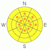
BOTTOM LINE
Danger by aspect and elevation on slopes approaching 35° or steeper.
(click HERE for tomorrow's danger rating)
|

Danger Rose Tutorial
|
Good skiing and Riding where the sun didn't get it yesterday. Limited avalanche activity from this last storm but weak snowpack structures exist on E-NE-NW facing slopes. MODERATE overall avalanche danger with pockets of CONSIDERABLE danger on E-NE-NW facing slopes at MId and Upper elevations. More snow on the way means that the danger will again be on the rise as the snow piles up over the next few days. Enjoy. Carefully. |
|
|
CURRENT CONDITIONS |

|
There is some good skiing and riding out there in the Mountains of SE Utah. Powder time again. There were a lot of other folks up on the hill yesterday for Midweek. Guess the game is on. All well behaved skiers in relatively benign areas. Folks were taking advantage of the Southwest faces yesterday before the solar destruction of the good skiing on those aspects. Of course, some in the N. Woods too, where to snow was quite good. Sunny sides will be done after yesterday's bake-off but E-NE-NW facing slopes will provide some excellent conditions. Word of caution, we are not out of the avalanche woods yet, so read on....We picked up almost 11" of snow from that last storm and more is headed our way.
The road to the Geyser Pass and Dark Canyon winter trailheads have been plowed and are in 2wd shape. Slippery in spots!
Matt Hebbard, definitely in the running for LUNA volunteer of the year, was up grooming yesterday and did the entire Nordic Track into Gold Basin and up to Geyser Pass including the upper and lower Nordic Loops, solo. Thanks Matt! |
|
|
RECENT ACTIVITY |

|
Not as much as I thought we'd see. Class II's on the North face of Tukno, and out of one of "the Cleavers" in the Middle Cirque of Gold Basin, and a larger class II-III off the North face of Mt. Tukunikuvatz. We have seen the one off Tukunikuvatz run already this year and it is a repeater in a thin snowpack area. Lot's of white out there and what is surprising is how few slopes actually ran. I guess we just didn't reach the critical load in many areas. |
|
|
THREAT #1 |

|
| WHERE |
PROBABILITY |
SIZE |
TREND |
|
|
|
|
| |
|
|
Over the next
48 hours.
|
|
|
Link to the U.S. Avalanche danger scale here: utahavalanchecenter.org/education/dangerscale
Mother nature seems to have ajdusted to the new load of snow in the Mountains (1.27" h2o in the La Sals, 1.6"Abajos) . Observed avalanche activity has been very limited. Some decent ones in Gold Basin. However, still VERY hesitant to lower the Danger rating by much as the snowpack continues to produce "whumpfs" and collapses in thin snowpack areas such as the one I experienced skinning back up Julie's Glade yesterday. It is also well documented that this snow fell onto a very weak old snow structure. There are buried surface hoar layers in the snowpack, as well as now buried faceted grains that formed at the top of the snowpack during the high pressure before this storm. The sunny slopes have a crust on them that will keep the snow in place, but on mid and upper elevation E-NE-NW facing slopes we are keeping pockets of considerable avalanche danger in the forecast. I fear that there are slabs of new snow out there that are teetering on the balance point between strength and stress, waiting for something to tip the balance. I still think that human triggered avalanches are possible out there in the La Sals and the Abajos. |
|
|
THREAT #2 |

|
| WHERE |
PROBABILITY |
SIZE |
TREND |

|
|
|
|
| |
|
|
Over the next
48 hours.
|
|
|
Lingering persistent slab possibilities have re-surfaced with this new snow load. Thinner snowpack areas where the mid-pack has been broken down into sugary crystals are suspect. Areas holding less than three feet or so of snow are particularly suspect. If you can poke your pole to the ground easily in a thin snowpack area, you'll know what I'm talking about. Lower and Mid-elevation areas that didn't have the snow coverage before this storm are to be approached with extra caution. This would include areas such as Corkscrew Glades or Colorado Bowl. |
|
|
MOUNTAIN WEATHER |

|
Mountain Weather for SE Utah at 10,000 ft: More snow on the way...
Today: Snow likely, mainly after 11am. Cloudy, with a high near 25. South wind between 5 and 10 mph. Chance of precipitation is 60%. Total daytime snow accumulation of 1 to 3 inches possible. Tonight: Snow likely. Cloudy, with a low around 11. West wind around 10 mph. Chance of precipitation is 70%. New snow accumulation of 3 to 5 inches possible. Friday: A 30 percent chance of snow, mainly before 11am. Mostly cloudy, with a high near 22. Southwest wind between 5 and 10 mph. Friday Night: Snow likely, mainly after 11pm. Cloudy, with a low around 13. South wind between 5 and 15 mph. Chance of precipitation is 60%. New snow accumulation of 1 to 3 inches possible. Saturday: Snow likely. Cloudy, with a high near 23. Breezy, with a south southwest wind between 15 and 20 mph. Chance of precipitation is 70%. Saturday Night: A 40 percent chance of snow. Cloudy, with a low around 7. Sunday: Mostly cloudy, with a high near 24. Sunday Night: A slight chance of snow. Mostly cloudy, with a low around 13. Presidents' Day: A chance of snow. Cloudy, with a high near 25. |
|
|
This information does not apply to developed ski areas or highways where avalanche control is normally done. This advisory is from the U.S.D.A. Forest Service, which is solely responsible for its content. This advisory describes general avalanche conditions and local variations always occur. |
|
This advisory provided by the USDA Forest Service, in partnership with:
The Friends of the Utah Avalanche Center, Utah Division of State Parks and Recreation, Utah Division of Emergency Management, Salt Lake County, Salt Lake Unified Fire Authority and the friends of the La Sal Avalanche Center. See our Sponsors Page for a complete list. |
