BOTTOM LINE
Danger by aspect and elevation on slopes approaching 35° or steeper.
(click HERE for tomorrow's danger rating)
|
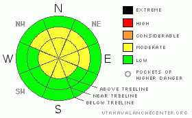
Danger Rose Tutorial
|
Watch new snow accumulations, they may change the avalanche conditions from our current danger rating very quickly. Variable conditions are being reported in SE Utah. There is some good powder skiing on sheltered East and North facing slopes. There is also some wind damage being reported out there. Be careful in wind affected areas as there are some weak layers in the upper pack. MODERATE avalanche danger on mid and upper elevation shady side slopes. Any significant new snow totals from this storm cycle we are entering will cause a significant spike in the avalanche danger. |
|
|
CURRENT CONDITIONS |

|
Our snowpack totals have slipped to below 100% of normal in the La Sals (108%in the Abajos) and driving up from the south you can really appreciate that fact. The La Sals look really barren. With the bulk of our SE Utah snowpack having fallen in December, the wind and sun have had a lot of time to work on the sunny slopes we see from the highway and from Moab. What is surprising is the great quality snow we found on the North Face of Abajo Peak on Thursday. On a short tour up North Canyon in the Blue Mountains out of Monticello, we found good creamy powder skiing in nicely spaced trees on a steep NW facing slope. What we found was better than expected and more of this type of skiing can be found if you head out to the right locations which are, as usual, mid elevation E-NE-NW facing slopes. If you're looking for something different, check your map out and go check out the Abajos. There is easy access, some really good terrain and new snow (hopefully) on the way. The old Blue Mountain ski resort is a great tour and that's just the start. San Juan County is quick to plow access along the Blue Mountain loop road as well. As of this afternoon, we'd only had a trace of new snow and our Gold Basin study plot stands at 38 inches.
The roads to the Geyser Pass Trailhead and the Dark Canyon Trailhead are plowed and in great shape providing access for 2wd vehicles. If we get any of the forecast snow tonight, access will no doubt be tougher.
LUNA volunteers groomed the the Geyser Pass Road today and the Upper Nordic Loop on the East side of the pass. Good job Michael and Tony. |
|
|
RECENT ACTIVITY |

|
We'll be watching closely as the snow piles up into next week. I expect some action depending on our snow/wind totals. |
|
|
THREAT #1 |

|
| WHERE |
PROBABILITY |
SIZE |
TREND |
|
|
|
|
| |
|
|
Over the next
48 hours.
|
|
|
Link to the U.S. Avalanche danger scale here: utahavalanchecenter.org/education/dangerscale
Right now, there is not a lot going on in the avalanche realm. We're almost two weeks out from the last storm. and there is not a lot of slab tension being found as people get farther into the mountains. What is being consistently found are some very weak layers above and below a rime crust that formed at the start of our last storm. With winds this past week I am hesitant to lower the Avalanche Danger below MODERATE on mid and upper elevation E-NE-NW facing slopes above treeline, but I think we are on the lower end of that. RIGHTNOW.
So far we've picked only a skiff of new snow but expect the avalanche danger to rise in relation to the wind and snow we receive from this next series of storms. We've got an old snowpack with several weak layers in the upper foot or so and it is not going to take much snow to push us into an avalanche cycle. |
|
|
MOUNTAIN WEATHER |

|
MOUNTAIN WEATHER FORECAST FOR SE UTAH at 10000 ft: Looks like a decent snow producer...
Tonight: Cloudy, with a low around 20. South southeast wind between 10 and 15 mph. Saturday: A 40 percent chance of snow. Cloudy, with a high near 37. South southeast wind around 10 mph. Saturday Night: A chance of snow before 11pm, then snow and areas of blowing snow after 11pm. Low around 24. Southeast wind between 10 and 15 mph. Chance of precipitation is 80%. New snow accumulation of 2 to 4 inches possible. Sunday: Snow and areas of blowing snow. High near 24. South southeast wind around 15 mph. Chance of precipitation is 80%. New snow accumulation of 5 to 9 inches possible. Sunday Night: Snow. Low around 21. Breezy, with a southwest wind between 15 and 20 mph, with gusts as high as 35 mph. Chance of precipitation is 90%. Monday: Snow likely. Cloudy and breezy, with a high near 21. Chance of precipitation is 60%. Monday Night: Snow likely. Cloudy, with a low around 6. Chance of precipitation is 60%. Tuesday: Snow likely. Cloudy, with a high near 21. |
|
|
This information does not apply to developed ski areas or highways where avalanche control is normally done. This advisory is from the U.S.D.A. Forest Service, which is solely responsible for its content. This advisory describes general avalanche conditions and local variations always occur. |
|
This advisory provided by the USDA Forest Service, in partnership with:
The Friends of the Utah Avalanche Center, Utah Division of State Parks and Recreation, Utah Division of Emergency Management, Salt Lake County, Salt Lake Unified Fire Authority and the friends of the La Sal Avalanche Center. See our Sponsors Page for a complete list. |
