SPECIAL ANNOUNCEMENT |
 |
Sledders! Please keep the road below the Geyser Pass Winter trailhead parking lot open. You can park below the sled hill but DON'T BLOCK THE ROAD! If incidents and inconsiderate behaviour continue below the sled hill the Forest Service may have to close this area to parking. The Forest Service has had a lot of complaints. |
|
|
BOTTOM LINE
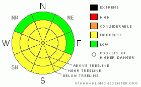
Danger by aspect and elevation on slopes approaching 35° or steeper.
(click HERE for tomorrow's danger rating)
|

Danger Rose Tutorial
|
Variable conditions are being reported in SE Utah. There is some good powder skiing on sheltered East and North facing slopes. There is also some wind damage being reported out there. Good luck finding good snow and be careful in wind affected areas as there are some weak layers in the upper pack. MODERATE avalanche danger on mid and upper elevation shady side slopes, E-NE-NW and again MODERATE danger on upper elevation SE-S-W facing slopes. Winds from the north the last few days have been managing to move around what little snow is available for transport. Watch out for localized wind pockets up high and daytime heating on sunny sides. |
|
|
CURRENT CONDITIONS |

|
It is a major mixed bag of conditions in SE Utah at the moment. We've dropped below 100% of our normal snowpack measured at the NRCS Snotel site, and coverage on the mountain at lower elevations and in wind affected areas seems to reflect that. Some areas have decent coverage while other have been stripped of their snowpack or just never received that much to begin with. The professionals call it "spatial variability" , meaning that there's a huge range of snow quality and snowpack strength over a given area. This term is frequently used to describe southwestern snowpack situations and it's appropriate now. The upside of this situation is that there ARE some nice snow conditions to be found out there. Good powder skiing is being found in the N. Woods still and in places in Gold Basin. Mid-elevation E and N facing slopes are your best bet. The meadows are not yet baked so good riding is out there for snowmachiners too. Time to think outside the box as far as powder goes. Hopefully we'll pick up more snow this weekend. We have bout 39 inches of snow at our Gold Basin study plot.
The roads to the Geyser Pass Trailhead and the Dark Canyon Trailhead are plowed and in great shape providing access for 2wd vehicles. The Geyser Pass road is getting slippery so keep the speed down.
LUNA volunteers groomed the entire nordic track Monday including the Upper Nordic Loops east of Geyser Pass, the Gold Basin Road and the Lower Nordic Loops. The track is firm, fast and in great shape. Good Job groomers! |
|
|
RECENT ACTIVITY |

|
Large R2D3 avalanche off the North face of Mt. Tukunkuvatz into Red Snow Cirque. Another R2D2 slide off the SE face of Tukno. Pretty impressive. These ran at some point midweek last week. Probably associated with South winds last Mon/Tues that topped out at over 60 MPH. I am surprised that we did not see more avalanches with over an inch of water and high winds falling on to a weak underlying snowpack. |
|
|
THREAT #1 |

|
| WHERE |
PROBABILITY |
SIZE |
TREND |

|
|
|
|
| |
|
|
Over the next
48 hours.
|
|
|
Link to the U.S. Avalanche danger scale here: utahavalanchecenter.org/education/dangerscale
Snowpit tests from many locations and elevations over the weekend revealed a consistent theme. Weak snow around a buried rime crust about 6-8 inches below the snow surface. Temperature gradients around warm crusts in the snowpack often cause a localized weakening of snow grains immediately above and below these crusts. These weaker snow grains can be failure layers when subsequent storm snows or wind loads are applied to them, as evidenced by the Mt. Tuk and Tukno avalanches in Red Snow Cirque. While not widespread and certainly the result of windloading, these slide define the potentail of these weak layers very well. We'll have the wait and see what the next storm brings but if we get a large dump of new snow, expect to see a large avalanche cycle.
At the moment, there is not a lot going on in the avalanche realm. We're over a week out from the last storm. Due to the winds this past week, the weak layers around the Rime Crust and it's development as a possible bed surface I am keeping the Avalanche Danger rating at MODERATE on mid and upper elevation E - NE -NW and all slopes above 11,500 ft steeper than 30 degrees.Keep an eye out for localized pockets of wind depostion in your travels. |
|
|
THREAT #2 |

|
| WHERE |
PROBABILITY |
SIZE |
TREND |

|
|
|
|
| |
|
|
Over the next
8 hours.
|
|
|
With warm daytime temperatures forecast over the next two days, we'll have to keep a heads up for wet slides in the afternoon as things warm up on the sunny sides. If you're out on a steep Southeast, South or West facing and it's getting soft, wet and mushy, it's time to move on. Seeing rollerballs? Point releases from rocks and trees? This indicates the the danger of wet slides is on the increase. |
|
|
MOUNTAIN WEATHER |

|
La Sal Mountain Weather for 10,000 ft: High Pressure cont'd, maybe some snow this weekend.
Today: Sunny, with a high near 47. Calm wind. Tonight: Mostly clear, with a low around 26. Calm wind becoming east southeast around 5 mph. Thursday: Partly sunny, with a high near 46. South wind around 5 mph. Thursday Night: A 40 percent chance of snow. Mostly cloudy, with a low around 26. South southeast wind between 10 and 15 mph. Friday: A 50 percent chance of snow. Cloudy, with a high near 28. Breezy, with a southwest wind between 20 and 25 mph. Friday Night: A 50 percent chance of snow. Cloudy and breezy, with a low around 15. Saturday: Snow likely. Cloudy, with a high near 27. Chance of precipitation is 60%. Saturday Night: Snow likely. Cloudy, with a low around 14. Sunday: Snow likely. Cloudy, with a high near 23. Sunday Night: A chance of snow. Mostly cloudy, with a low around 12. Monday: A chance of snow. Mostly cloudy, with a high near 29. |
|
|
This information does not apply to developed ski areas or highways where avalanche control is normally done. This advisory is from the U.S.D.A. Forest Service, which is solely responsible for its content. This advisory describes general avalanche conditions and local variations always occur. |
|
This advisory provided by the USDA Forest Service, in partnership with:
The Friends of the Utah Avalanche Center, Utah Division of State Parks and Recreation, Utah Division of Emergency Management, Salt Lake County, Salt Lake Unified Fire Authority and the friends of the La Sal Avalanche Center. See our Sponsors Page for a complete list. |


