SPECIAL ANNOUNCEMENT |
 |
Sledders! Please keep the road below the Geyser Pass Winter trailhead parking lot open. You can park below the sled hill but DON'T BLOCK THE ROAD! If incidents and inconsiderate behaviour continue below the sled hill the Forest Service may have to close this area to parking. The Forest Service has had a lot of complaints. |
|
|
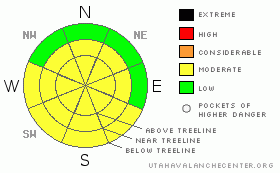
BOTTOM LINE
Danger by aspect and elevation on slopes approaching 35° or steeper.
(click HERE for tomorrow's danger rating)
|
Danger Rose Tutorial
|
Variable conditions are being reported in SE Utah. There is some good powder skiing on sheltered East and North facing slopes. There is also some wind damage being reported out there. Good luck and be careful in wind affected areas as there are some weak layers in the upper pack. MODERATE avalanche danger on mid and upper elevation shady side slopes, E-NE-NW and again MODERATE danger on upper elevation SE-S-W facing slopes. These zones are where the winds have been moving snow around and where the old snow was weakest before our last storm. Watch the daytime heating. |
|
|
CURRENT CONDITIONS |

|
Mother nature has had the better part of a week to settle into her new snow load and the winds have died down over the last few days. Good news for the stability of the snowpack. Good conditions can be found among the wind stripped and and windcrusted slopes if you stick to mid-elevations and shady aspects. There is some really good snow out there if you're willing to snoop around. With a declining (not gone though...) avalanche hazard and some good snow out there for the adventurous skier, it is a good time to go out and explore beyond the North Woods. As you venture into more exciting and adventurous terrain, make sure you enter avalanche paths one at a time and stay clear of runouts while your partner skis or rides. Be aware of daytime heating this weekend and get off sunny side slopes when they get really soft and wet.
The Roads to all trailheads (including Dark Canyon) are in good shape. 2wd access at the moment. Thank You San Juan County.
Luna Groomed up into Gold Basin Tuesday and also did the Lower Nordic Loops. The Geyser Pass Raod and Upper Nordic Loops were groomed yesterday. It's all in tremendous shape for the weekend. |
|
|
RECENT ACTIVITY |

|
Nothing of note. We've been looking too. San Juans active up to two days ago. |
|
|
THREAT #1 |

|
| WHERE |
PROBABILITY |
SIZE |
TREND |

|
|
|
|
| |
|
|
Over the next
48 hours.
|
|
|
Link to the U.S. Avalanche danger scale here: utahavalanchecenter.org/education/dangerscale
We did not see anything on our tour into Horse Creek Wednesday that gave us cause for alarm. Although there are weak layers to be found in the upper snowpack, snowpit tests showed a more stable snowpack than we expected (below treeline that is) and there has been no observed avalanche activity. We are keeping the avalanche danger rating at MODERATE at and above treeline on NW-NE-E facing terrain. We are also keeping the danger rating at MODERATE on SE - S - W facing terrain above treeline. These zones are where the winds have been moving the most snow around and wind depositions are likely to be higher. There were some weak layers at the old snow surface in the form of near surface faceted crystals and surface hoar deposits. We do not seem to have had enough snow to activate these weak layers even though they are still quite visible in snowpit tests. This near surface faceting appears to be the culprit in a very close call outside of the Telluride ski resort 2 days ago. A backcountry skier triggered a slide in Bear Creek taking a nasty ride. He was buried with his hand out and rescuers were able to get him out before he reached his expiration date. It sounds like he was very lucky. While they received more snow than we did in Telluride out of this last storm, keep in mind that our snowpack is very similar to theirs and tread lightly. This is the La Sals.
Check out Wednesday's pit profile here:
www.avalanche.org/~lsafc/snowpit/LaSalProfiles08-09/01-28-09,Horse Creek.jpg |
|
|
THREAT #2 |

|
| WHERE |
PROBABILITY |
SIZE |
TREND |

|
|
|
|
| |
|
|
Over the next
8 hours.
|
|
|
Today will be the warmest day we've had in quite a while. Heads up for wet slides in the afternoon as things warm up on the sunny sides. If you're out on a steep Southeast, South or West facing and it's getting soft, wet and mushy, it's time to move on. |
|
|
MOUNTAIN WEATHER |

|
La Sal Mountain Weather for 10,000 ft: High Pressure
Today: Mostly sunny, with a high near 43. South wind around 5 mph becoming calm. Tonight: Partly cloudy, with a low around 23. Calm wind becoming southwest around 5 mph. Sunday: Partly sunny, with a high near 35. Calm wind becoming north northwest around 5 mph. Winds could gust as high as 20 mph. Sunday Night: Mostly cloudy, with a low around 19. North northeast wind around 5 mph becoming calm. Monday: Sunny, with a high near 37. Calm wind becoming northwest around 5 mph. Monday Night: Mostly clear, with a low around 18. Tuesday: Sunny, with a high near 41. |
|
|
This information does not apply to developed ski areas or highways where avalanche control is normally done. This advisory is from the U.S.D.A. Forest Service, which is solely responsible for its content. This advisory describes general avalanche conditions and local variations always occur. |
|
This advisory provided by the USDA Forest Service, in partnership with:
The Friends of the Utah Avalanche Center, Utah Division of State Parks and Recreation, Utah Division of Emergency Management, Salt Lake County, Salt Lake Unified Fire Authority and the friends of the La Sal Avalanche Center. See our Sponsors Page for a complete list. |
