SPECIAL ANNOUNCEMENT |
 |
Sledders! Please keep the road below the Geyser Pass Winter trailhead parking lot open. You can park below the sled hill but DON'T BLOCK THE ROAD! If incidents and inconsiderate behaviour continue below the sled hill the Forest Service may have to close this area to parking. The Forest Service has had a lot of complaints. |
|
|
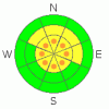
BOTTOM LINE
Danger by aspect and elevation on slopes approaching 35° or steeper.
(click HERE for tomorrow's danger rating)
|

Danger Rose Tutorial
|
8-9 inches of new snow, good dense snow with a lighter finish. No observed avalanche activity. Hardly seems like SE Utah. Good conditions can be found in lot's of places. Some South and SW facing slopes damaged by riming and wind. Other wise things looking good. CONSIDERABLE avalanche danger above treeline so heads up where the winds have been active. |
|
|
CURRENT CONDITIONS |

|
In What may be a perfect storm for SE Utah, we've picked up 1.1 inches of water in 9 inches of snow at our La Sal Gold Basin study Plot. Since Friday Morning or so, we've had a series of impulses on a south flow that dropped increasingly lower density snow on mountains of Utah and Colorado. While our snow totals are at the lower end of the regional totals, that may be a blessing in disguise. Our old snow surface was quite weak, a really big hit of snow, or this snow coming in over one night instead of four, and we might have been in an impressive avalanche cycle. Instead, we've got light density snow over thicker stuff and it has fallen slowly enough as to not overload the weak layers in the snowpack. We're looking good in terms of both snow quality and stability, although it's worth mentioning that the winds have been moving snow around, and some typically wind affected areas are stripped. Our tour to Pinto Glades today, where we thought we'd be ahead of the sun and get some good south facing turns in, led to disappointment when we saw that there was no snow in there. There is great skiing and riding in a lot of places though, and we're looking good with 43 inches of snow at the Gold Basin study plot, putting us at 105% of normal on the season.
The Roads to all trailheads (including Dark Canyon) are in good shape. 2wd access at the moment. Thank You San Juan County.
Luna Groomed up into Gold Basin Tuesday and also did the Lower Nordic Loops. What has been groomed is in really good shape. Code Blue. Cold Wax. |
|
|
RECENT ACTIVITY |

|
Nothing of note. We've been looking too. |
|
|
THREAT #1 |

|
| WHERE |
PROBABILITY |
SIZE |
TREND |
|
|
|
|
| |
|
|
Over the next
48 hours.
|
|
|
Link to the U.S. Avalanche danger scale here: utahavalanchecenter.org/education/dangerscale
Happy to report little to no activity from this last storm and even with weak layers in the snowpack we could see little to alarm us about the current snowpack in our snowpit tests today. This was below treeline however and the winds have been moving snow around in open areas at and above treeline. We had strong winds from the SW during the storm with gusts in the 60's. Yesterday, the winds came around from the north, so expect erratic loading patterns and possible cross-loading above treeline. For this reason keeping pockets of CONSIDERABLE danger, meaning human triggered avalanches are possible, in the forecast. Expect a MODERATE to LOW avalanche danger below treeline. Things look stable where we've been, but we've had new snow with wind so don't push your slope angles too far. A thorough stability analysisis of any avalanche terrain you're considering entering is always always required this close to a storm.
Check out today's pit profile here:
www.avalanche.org/~lsafc/snowpit/LaSalProfiles08-09/01-28-09,Horse Creek.jpg |
|
|
MOUNTAIN WEATHER |

|
La Sal Mountain Weather for 10,000 ft:
Tonight: A 50 percent chance of snow. Mostly cloudy, with a low around 8. West northwest wind around 5 mph becoming south southeast. Winds could gust as high as 25 mph. Total nighttime snow accumulation of less than a half inch possible. Thursday: A 30 percent chance of snow before 11am. Mostly cloudy, with a high near 21. East southeast wind 5 to 10 mph becoming northwest. Winds could gust as high as 25 mph. Thursday Night: Partly cloudy, with a low around 11. West wind between 5 and 10 mph becoming calm. Friday: Sunny, with a high near 37. Calm wind becoming west northwest around 5 mph. Friday Night: Mostly clear, with a low around 20. West wind around 5 mph becoming calm. Saturday: Mostly sunny, with a high near 38. Saturday Night: Mostly cloudy, with a low around 14. Sunday: Partly sunny, with a high near 31. |
|
|
GENERAL ANNOUNCEMENTS |
Our yearly AIARE level I avalanche course will be held this year from Friday, January 30th - Sunday February 1st. Proceeds from this class go directly to the Friends of La Sal Avalanche Center and help pay for the forecasting and education services provided by the Center. Please call Dave or Max 435-636-3363 to sign up for the class or get more information. |
|
|
This information does not apply to developed ski areas or highways where avalanche control is normally done. This advisory is from the U.S.D.A. Forest Service, which is solely responsible for its content. This advisory describes general avalanche conditions and local variations always occur. |
|
This advisory provided by the USDA Forest Service, in partnership with:
The Friends of the Utah Avalanche Center, Utah Division of State Parks and Recreation, Utah Division of Emergency Management, Salt Lake County, Salt Lake Unified Fire Authority and the friends of the La Sal Avalanche Center. See our Sponsors Page for a complete list. |
