SPECIAL ANNOUNCEMENT |
 |
Sorry about the late update. Internet frustrations......
Sledders! Please keep the road below the Geyser Pass Winter trailhead parking lot lot open. You can park below the sled hill but DON'T BLOCK THE ROAD! If incidents and inconsiderate behaviour continue below the sled hill the Forest Service may have to close this area to parking. The Forest Service has had a lot of complaints. |
|
|
BOTTOM LINE
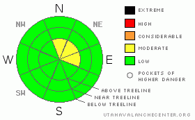
Danger by aspect and elevation on slopes approaching 35° or steeper.
(click HERE for tomorrow's danger rating)
|
Danger Rose Tutorial
|
LOW to MODERATE Hazard of Avalanches in the Mountains of SE Utah on above treeline shady side slopes. Good snow conditions can still be found but creativity required. Sun and wind have affected many slopes but good sking and riding on re-crystallized powder can still be found out there. |
|
|
CURRENT CONDITIONS |

|
The snow conditions in SE Utah are not too bad considering we are 11 days out from our last snowfall. We found good skiing yesterday on -recrystallized surface snow with a supportable base in Tele Gold. This re-crystallized snow - square powder - is skiing really nice and the process is breaking down some of the wind crusts formed earlier this week. This re-crystallized snow, actually well developed near surface facets at this point, will come back to haunt us later when and if we get some new snow. We can worry about that later, in the meantime, there are some good conditions out there if you stay away from sun and wind affected slopes. We have 37.5 inches of snow on the ground at the Gold Basin study plot and are at 111-118 % of normal in SE Utah.
The road to the Geyser Pass trailhead is plowed nicely, but it is getting slick so keep the speed down. The road to the Dark Canyon winter trailhead on the East side of the La Sals has also been plowed. Thank You San Juan County.
LUNA was up Firday and groomed the entire Nordic Track and it is in GREAT shpe. The skating is firm and fast. Good job Kirsten and Harold. This is one advantage of the extended high pressure. |
|
|
RECENT ACTIVITY |

|
Some recent point releases noted in the forest between Exxon's Folly and Tukno. Very shallow areas with rotten snow stripped to the ground and rock. Warming? We saw nothing indicating this could happen again on our tour Friday. |
|
|
THREAT #1 |

|
| WHERE |
PROBABILITY |
SIZE |
TREND |
|
|
|
|
| |
|
|
Over the next
48 hours.
|
|
|
Link to the U.S. Avalanche danger scale here: utahavalanchecenter.org/education/dangerscale
Upper elevation wind loaded slopes are the number one avalanche threat right now. We are keeping the avalanche danger at moderate on above treeline E-NE-N facing slopes, and I feel we are on the lower end of that scale. The winds HAVE been active this past week, plumes have been visible from town and there are still some pockets of wind drifted snow out there that could release. High mark and ski one at a time as we venture deeper into the backcountry in search of good snow.Also remember that the La Sals are the International Center for Snow Wierdness, and if any unlikely avalanche event is going to happen, it will be here. |
|
|
MOUNTAIN WEATHER |

|
La Sal Mountain Weather for 10,000 ft: Still High and Dry...
Today: Mostly sunny, with a high near 41. Calm wind becoming west northwest around 5 mph. Tonight: Mostly clear, with a low around 19. Calm wind becoming north northeast around 5 mph. Sunday: Mostly sunny, with a high near 41. North northeast wind around 5 mph. Sunday Night: Mostly clear, with a low around 22. Calm wind becoming north northwest around 5 mph. M.L.King Day: Sunny, with a high near 42. North northeast wind around 5 mph. Monday Night: Mostly clear, with a low around 25. Tuesday: Sunny, with a high near 42. Tuesday Night: Mostly clear, with a low around 27. Wednesday: Partly sunny, with a high near 42. Wednesday Night: A slight chance of snow. Mostly cloudy, with a low around 24. Thursday: A chance of snow. Mostly cloudy, with a high near 35. Thursday Night: A chance of snow. Mostly cloudy, with a low around 21. Friday: A chance of snow. Mostly cloudy, with a high near 33. |
|
|
GENERAL ANNOUNCEMENTS |
Our yearly AIARE level I avalanche course will be held this year from Friday, January 30th - Sunday February 1st. Proceeds from this class go directly to the Friends of La Sal Avalanche Center and help pay for the forecasting and education services provided by the Center. Please call Dave or Max 435-636-3363 to sign up for the class or get more information. |
|
|
This information does not apply to developed ski areas or highways where avalanche control is normally done. This advisory is from the U.S.D.A. Forest Service, which is solely responsible for its content. This advisory describes general avalanche conditions and local variations always occur. |
|
This advisory provided by the USDA Forest Service, in partnership with:
The Friends of the Utah Avalanche Center, Utah Division of State Parks and Recreation, Utah Division of Emergency Management, Salt Lake County, Salt Lake Unified Fire Authority and the friends of the La Sal Avalanche Center. See our Sponsors Page for a complete list. |
