BOTTOM LINE
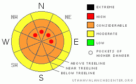
Danger by aspect and elevation on slopes approaching 35° or steeper.
(click HERE for tomorrow's danger rating)
|
Danger Rose Tutorial
|
CONSIDERABLE Hazard of Avalanches in the Mountains of SE Utah. 3 feet plus of new snow in the Central La Sals, more than that in the Abajos, falling onto weak snow structures. Beware of deep, long lasting slab instabilities.
Improving coverage and excellent conditions can be found in the backcountry traveler in SE Utah right now. Have an even better time by keeping the slope angles below 30 degrees and staying clear of avalanche runout zones. Have fun. Expect early season conditions with significant ground hazard. There are some excellent snow conditions out there, just don't get into trouble trying to find'em. |
|
|
CURRENT CONDITIONS |

|
There are some great riding and skiing conditions in the Mountains of SE Utah at this time. We've had over 3 feet of snow in the last week with a couple of nice days for things to settle out. Today we skied nice supportable powder down the ridge on the skiers left side of the North Woods then dropped in. It was really nice up top but as we descended to about the bottom third of the run, conditions became sort of "punchy" and the snow cover a little more dangerous and thin. it's good out there, but it's still early season, so don't hit a stump in the North Woods! On a more positive note, the coverage IS getting better, one more good storm and we should get through the rotten stage and into more supportable skiing.
The Road to the Geyser pass trailhead is buffed. It's in great shape though as always, a minimum of chains carried in your 2wd vehicle are recommended in case it gets slick.Thanks alot San Juan County. It looks great.
Grooming Conditions: Full track up and over Geyser Pass has been groomed for the first time this year. Big effort by LUNA today. GO get it. Classic and skate skiing Gold Basin and Lower Loops are in excellent condition for classic and skate cross-country skiing also. |
|
|
RECENT ACTIVITY |

|
Several avalanches were observed last week before the last 14 inches of snow. More were observed today on our tour to the Laurel Ridge Weather Station. These include:
Upper Horse Creek - Soft Slab? Natural, 500' wide x 2-3 feet deep x 1000' vertical. Check out this photo sent in Sunday. www.avalanche.org/~lsafc/aviphotos/LaSalPhotos08-09/12-28-08,Upper Horse Creek, Condie.jpg
Dorry Canyon - SS-NN-R2D2, 2' deep x 200' wide
Snaggletooth Face - Several class 2 avi's in a series of 4-500' couloirs.
Tukno NE Face - SS-NN-R3D2.5 - Large avalanche that ran sometime during Thursday's snow. Impressive.
Talking Mountain Cirque (including lower El Pinche Couloir) SS-NN-R4-D2.5. About 1000' feet wide below the cliffs. Very Widespread.
Laurel Cirque - SS-NN-R4D2. Very Wide but not too deep.
Mt Mellenthin - North face - SS-NN-R3D2.5 - Pretty big one. 2' x 500' |
|
|
THREAT #1 |

|
| WHERE |
PROBABILITY |
SIZE |
TREND |

|
|
|
|
| |
|
|
Over the next
48 hours.
|
|
|
Link to the U.S. Avalanche danger scale here: utahavalanchecenter.org/education/dangerscale
Major Snowfall across the west has resulted in very unstable snowpack conditions in many areas including the La Sal and Abajo Mountains of Se Utah. Over the past weekend, tragically, there were 11 deaths in the US and Canada. In Utah we escaped with only minor scrapes in Northern Utah and people seem to be minding the avalanche danger accordingly. Good work.
We are dropping our avalanche danger rating in SE Utah to CONSIDERABLE having given mother nature 3 solid days to adjust to her new snow load. Our remaining problem is the old underlying snowpack. The faceted crystals at the bottom of our snowpack are notorious for long lasting instability, far beyond the natural triggering process (i.e. snowfall or wind loading). If another trigger, say a skier or snowmachine, comes along and triggers one of these now thick slabs of snow, the results are going to be dangerous, deep and powerful. It is very difficult to predict these types of avalanches other than to recognize the situation that they take place under, and to note that they are happening. We have the snowpack, weak base layers (facets), with large early season loads recently applied to them, that have settled into harder brittle slabs of snow. More importantly, looking around, we see avalanche professionals getting burned by in-area avalanches and a mounting death toll. The deep slabs are happening. The allure of the powder has been coaxing people into trouble this season so heads up. It's still early in the year. |
|
|
MOUNTAIN WEATHER |

|
La Sal Mountain Weather for 10,000 ft: Relatively calm forecast through the weekend with a chance of snow.
Tonight:
Mostly cloudy, with a low around 18. South southwest wind around 5 mph becoming east southeast.
New Year's Day:
A 20 percent chance of snow. Mostly cloudy, with a high near 35. North northeast wind around 5 mph becoming west southwest.
Thursday Night:
Mostly cloudy, with a low around 19. West southwest wind around 5 mph becoming calm. Winds could gust as high as 25 mph.
Friday:
Partly sunny, with a high near 30. South wind around 5 mph, with gusts as high as 25 mph.
Friday Night:
A 30 percent chance of snow. Mostly cloudy, with a low around 15. Southwest wind around 15 mph.
Saturday:
A 50 percent chance of snow. Cloudy, with a high near 27.
Saturday Night:
A 40 percent chance of snow. Mostly cloudy, with a low around 13. |
|
|
GENERAL ANNOUNCEMENTS |
Our yearly AIARE level I avalanche course will be held this year from Friday, January 30th - Sunday February 1st. Proceeds from this class go directly to the Friends of La Sal Avalanche Center and help pay for the forecasting and education services provided by the Center. Please call Dave or Max 435-636-3363 to sign up for the class or get more information.
We will also be teaching some Avalanche Awareness seminars this winter. The first is scheduled for Monday, January 12th at 6:00 PM at the Grand County Library. These FREE seminars run about 2 hours and cover avalanche phenomena, basic travel techniques and self-rescue equipment overviews. They are a good opportunity to learn about the hazards of backcountry winter travel. Suitable for skiers, hikers, snow machiners, hunters and snowboarders. |
|
|
This information does not apply to developed ski areas or highways where avalanche control is normally done. This advisory is from the U.S.D.A. Forest Service, which is solely responsible for its content. This advisory describes general avalanche conditions and local variations always occur. |
|
This advisory provided by the USDA Forest Service, in partnership with:
The Friends of the Utah Avalanche Center, Utah Division of State Parks and Recreation, Utah Division of Emergency Management, Salt Lake County, Salt Lake Unified Fire Authority and the friends of the La Sal Avalanche Center. See our Sponsors Page for a complete list. |
