SPECIAL ANNOUNCEMENT |
 |
This is Dave Medara with the La Sal Avalanche Center. We are up and running for 2008-2009 season. We will be issuing twice weekly forecast through the 2008-2009 season. Forecasts are scheduled for Monday and Friday but this schedule may be altered to reflect changing conditions. Additional updates will be issued if the avalanche danger increases between scheduled forecasts. Budgetary restraints are the primary cause for this reduction in services. We are hoping that this is a temporary situation. |
|
|
BOTTOM LINE
Danger by aspect and elevation on slopes approaching 35° or steeper.
(click HERE for tomorrow's danger rating)
|

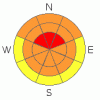
Danger Rose Tutorial
|
High Hazard of Avalanches in the Mountains of SE Utah. Much new snow, 2 feet plus in the Central La Sals, falling onto weak snow structures. There are also long lasting snow instabilities from a previous week of snow due to early season depth hoar development.
Improving (but not great!) coverage and excellent conditions await the backcountry traveler in SE Utah right now. Have an even better time by keeping the slope angles below 30 degrees and staying clear of avalanche runout zones. Have fun. |
|
|
CURRENT CONDITIONS |

|
Big snow down here is SE Utah, with the La Sals finally coming out on top of the heap with 24" of new snow at our Gold Basin study plot containing 2.3" water. The snow is very deep in places and there are excellent skiing and snowmobiling conditions out there. Blower powder and stuck snow machines were the order of our day. After getting a machine stuck it was not uncommon to dismount into chest deep snow. We saw several slides before we lost visibility. Conditions are epic, but ground coverage is still lean so heads up in the powder. And finally, the Avalanche Danger is very HIGH. Stay tuned for more on that.
The Geyser Pass road is unplowed at the moment as is the La Sal Mountain Loop Road. People were making it up to the turn off for Geyser Pass and parking there. San Juan County is supposed to be up there to plow up to the Geyser Pass Trailhead tomorrow morning.
Grooming? Maybe we'll track some of it back in tomorrow. There are several LUNA Volunteers going up to groom, but with the road opening late and this much snow, I'd say chances are slim that much grooming will actually get done. |
|
|
RECENT ACTIVITY |

|
Several avalanches were observed today, some of them natural releases and some of them snowmobile triggered. Largest of note was a natural avalanche in the Exxon's Folly Slide Path. This slide SS-NN-R2-D2 was about 250' wide by 2 feet deep and ran 600 vertical feet. It took out the lower portion of the middle colouir and a large portion of the lower bowl left of center. There is still a lot of the starting zone left intact as hangfire. We saw other class 2 slides over on Noriega's and in many more in the runouts of the smaller slide paths between Noriega's and Exxon's. From there we lost our visibility and the fun was over until we 'biled back down the Geyser Pass Road. On the way down we were able trigger of the road banks with hits from the snowmachines. It was pretty fun with no consequences, but the results we impressive. These road banks repeatedly released slides over 2 feet deep . They were small pockets, but sobering nonetheless. Check out this photo: www.avalanche.org/~lsafc/aviphotos/LaSalPhotos08-09/12-23-08,Geyser Pass Roadcut,DaveMedara.jpg
Link to crown profile:www.avalanche.org/~lsafc/snowpit/LaSalProfiles08-09/12-18-08,Juie%27s%20Backside-1.jpg from Julie's Backside slide on 12/18/08. This was BEFORE the last two feet of snow |
|
|
THREAT #1 |

|
| WHERE |
PROBABILITY |
SIZE |
TREND |
|
|
|
|
| |
|
|
Over the next
48 hours.
|
|
|
Link to the U.S. Avalanche danger scale here: utahavalanchecenter.org/education/dangerscale
New snow slabs have been built up in High elevation, Mid-elevation and even low elevation slopes (see avalanche activity) . Expect to to encounter a HIGH Avalanche Danger on upper elevation, shady side slopes on, or below, slopes of 30 degrees or steeper. Expect to find a CONSIDERABLE danger elsewhere. Coverage is finally getting deep enough that the avalanche potential is no longer limited to upper elevation, alpine bowls. You can't argue with 2 feet or more of new snow on an already weak snowpack. Natural avalanches are the best indicator that there is avalanche potential and several have been noticed . Keep your slope angles under 30 degrees. |
|
|
THREAT #2 |

|
| WHERE |
PROBABILITY |
SIZE |
TREND |
|
|
|
|
| |
|
|
Over the next
48 hours.
|
|
|
Bridging slabs formed by snowfall from 12/13 onward are still weak enough to collapse under the weight of backcountry travelers. We had several collapses into this older snow today and the snowpack was very LOUD. The SE Utah snowpack is very weak, with Basal Faceted Crystals already straining under the weight of the last week's snow. Unfortunately this type of snowpack structure is very slow to gain strength and the weight of this latest snow will only make these persistent slabs more dangerous. Deep, old snow releases are possible in the mid and upper elevation slopes of SE utah at this time. |
|
|
MOUNTAIN WEATHER |

|
La Sal Mountain Weather for 10,000 ft: Next storm to Impact the area will arrive Wednsday night and Christmas day.
Tonight:
Snow likely, mainly before 11pm. Mostly cloudy, with a low around -4. Wind chill values as low as -10. West wind between 5 and 10 mph becoming calm. Chance of precipitation is 60%. Total nighttime snow accumulation of 1 to 2 inches possible.
Wednesday:
Areas of blowing snow and a chance of snow. Mostly cloudy, with a high near 17. Wind chill values as low as -15. East southeast wind 5 to 10 mph becoming south southwest. Chance of precipitation is 40%.
Wednesday Night:
Snow and areas of blowing snow, mainly after 11pm. Low around 15. Breezy, with a south wind between 15 and 20 mph, with gusts as high as 30 mph. Chance of precipitation is 80%. New snow accumulation of 3 to 5 inches possible.
Christmas Day:
Snow and widespread blowing snow. High near 23. Breezy, with a south southwest wind between 15 and 25 mph, with gusts as high as 35 mph. Chance of precipitation is 80%. New snow accumulation of 4 to 8 inches possible.
Thursday Night:
Snow and widespread blowing snow. Low around 7. Windy, with a west wind between 25 and 30 mph, with gusts as high as 40 mph. Chance of precipitation is 80%. |
|
|
GENERAL ANNOUNCEMENTS |
Our yearly AIARE level I avalanche course will be held this year from Friday, January 30th - Sunday February 1st. Proceeds from this class go directly to the Friends of La Sal Avalanche Center and help pay for the forecasting and education services provided by the Center. Please call Dave or Max 435-636-3363 to sign up for the class or get more information.
We will also be teaching some Avalanche Awareness seminars this winter. The first is scheduled for Monday, January 12th at 6:00 PM at the Grand County Library. These FREE seminars run about 2 hours and cover avalanche phenomena, basic travel techniques and self-rescue equipment overviews. They are a good opportunity to learn about the hazards of backcountry winter travel. Suitable for skiers, hikers, snow machiners, hunters and snowboarders. |
|
|
This information does not apply to developed ski areas or highways where avalanche control is normally done. This advisory is from the U.S.D.A. Forest Service, which is solely responsible for its content. This advisory describes general avalanche conditions and local variations always occur. |
|
This advisory provided by the USDA Forest Service, in partnership with:
The Friends of the Utah Avalanche Center, Utah Division of State Parks and Recreation, Utah Division of Emergency Management, Salt Lake County, Salt Lake Unified Fire Authority and the friends of the La Sal Avalanche Center. See our Sponsors Page for a complete list. |
