SPECIAL ANNOUNCEMENT |
 |
This is Dave Medara with the La Sal Avalanche Center. We are up and running for 2008-2009 season. We will be issuing twice weekly forecast through the 2008-2009 season. Forecasts are scheduled for Monday and Friday but this schedule may be altered to reflect changing conditions. Additional updates will be issued if the avalanche danger increases between scheduled forecasts. Budgetary restraints are the primary cause for this reduction in services. We are hoping that this is a temporary situation. |
|
|
BOTTOM LINE
Danger by aspect and elevation on slopes approaching 35° or steeper.
(click HERE for tomorrow's danger rating)
|

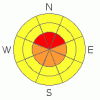
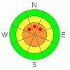
Danger Rose Tutorial
|
High Hazard of Avalanches in the Mountains of SE Utah. Weak snow structures making for long lasting snow instabilities due to early season depth hoar developement. Current storm cycle is adding to the already straining snowpack with heavy loads of new snow forecast to arrive tonight and tomorrow. Heads up in the Backcountry. Keep off, and out from underneath, slopes steeper than 30 Degrees. Head for a ski area if you're looking for the steep and deep. |
|
|
CURRENT CONDITIONS |

|
We're up to 4 or 5 inches of new snow from the latest winter storm with the brunt of the storm still to reach SE Utah. Powder skiing conditions will be improving, if you can find a location with adequate ground coverage that is. Expect a corresponding rise in the avalanche danger as well, more on that in the next section. We have 24" of snow on the ground at our Gold Basin study plot, with 4" of new snow measured there.
The Geyser Pass road is pretty rough right now and at least one party was turned back at the Squaw Springs TH parking lot. We'll keep you posted on road conditions (or any improvements to them...) as soon as we hear from San Juan County.
LUNA actually got out and groomed today and started pre-packing the road to Geyser Pass above Gold Basin and the upper meadows. The full circuit has now been packed out and we should be able to get the whole course groomed when we get into the next high pressure. |
|
|
RECENT ACTIVITY |

|
Human triggered avalanche triggered on the back side of Julie's glade Friday. HS-AS-R3-D2... Meaning that this avalanche, though pretty small, pulled out a sizable chunk of snow relative to the size of the path. If the skier who triggered it (myself) would have been caught, there could have been consequences. I triggered it from a safe spot near the edge of the slide in a classic thinner snowpack area after traversing over where the crown eventiually broke into stronger thicker snow. The crown face was over three feet deep and the pocket was about 60 feet wide. I have never seen this small pocket release in 15 years of skiing the La Sals. Heads Up!!
Link to crown profile:www.avalanche.org/~lsafc/snowpit/LaSalProfiles08-09/12-18-08,Juie%27s%20Backside-1.jpg |
|
|
THREAT #1 |

|
| WHERE |
PROBABILITY |
SIZE |
TREND |
|
|
|
|
| |
|
|
Over the next
48 hours.
|
|
|
Link to the U.S. Avalanche danger scale here: utahavalanchecenter.org/education/dangerscale
Deep Slabs are being built up on upper elevation North facing slopes by new snow and strong winds from the south. Expect to to encounter a HIGH Avalanche Danger on upper elevation, shady side slopes on, or below, slopes of 30 degrees or steeper. Coverage is finally getting deep enough that the avalanche potential is no longer limited to upper elevation, alpine bowls. |
|
|
THREAT #2 |

|
| WHERE |
PROBABILITY |
SIZE |
TREND |
|
|
|
|
| |
|
|
Over the next
48 hours.
|
|
|
Bridging slabs formed by snowfall from 12/13 onward are still weak enough to collapse under the weight of backcountry travelers. The SE Utah snowpack is very weak, with Basal Faceted Crystals straining under the weight of the last week's snow. Unfotunately this type of snowpack structure is very slow to gain strength and the weight of this latest snow will only make these persistent slabs more dangerous. |
|
|
MOUNTAIN WEATHER |

|
La Sal Mountain Weather for 10,000 ft:
Tonight:
Snow and areas of blowing snow. The snow could be heavy at times. Low around 9. Very windy, with a southwest wind 45 to 50 mph decreasing to between 30 and 35 mph. Winds could gust as high as 75 mph. Chance of precipitation is 100%. Total nighttime snow accumulation of 12 to 18 inches possible.
Tuesday:
Snow and areas of blowing snow. The snow could be heavy at times. High near 18. Wind chill values as low as -10. Breezy, with a west wind between 15 and 25 mph. Chance of precipitation is 80%. New snow accumulation of 3 to 7 inches possible.
Tuesday Night:
Snow, mainly before 11pm. Low around 9. Breezy, with a west wind 15 to 20 mph becoming south southwest 5 to 10 mph. Chance of precipitation is 80%. New snow accumulation of 1 to 3 inches possible.
Wednesday:
A 40 percent chance of snow. Cloudy, with a high near 21. East southeast wind 5 to 10 mph becoming south southwest.
Wednesday Night:
Snow, mainly after 11pm. Low around 15. South wind between 10 and 15 mph. Chance of precipitation is 80%.
Christmas Day:
Snow. High near 25. Breezy. Chance of precipitation is 80%. |
|
|
GENERAL ANNOUNCEMENTS |
Our yearly AIARE level I avalanche course will be held this year from Friday, January 30th - Sunday February 1st. Proceeds from this class go directly to the Friends of La Sal Avalanche Center and help pay for the forecasting and education services provided by the Center. Please call Dave or Max 435-636-3363 to sign up for the class or get more information.
We will also be teaching some Avalanche Awareness seminars this winter. The first is scheduled for Monday, January 12th at 6:00 PM at the Grand County Library. These FREE seminars run about 2 hours and cover avalanche phenomena, basic travel techniques and self-rescue equipment overviews. They are a good opportunity to learn about the hazards of backcountry winter travel. Suitable for skiers, hikers, snow machiners, hunters and snowboarders. |
|
|
This information does not apply to developed ski areas or highways where avalanche control is normally done. This advisory is from the U.S.D.A. Forest Service, which is solely responsible for its content. This advisory describes general avalanche conditions and local variations always occur. |
|
This advisory provided by the USDA Forest Service, in partnership with:
The Friends of the Utah Avalanche Center, Utah Division of State Parks and Recreation, Utah Division of Emergency Management, Salt Lake County, Salt Lake Unified Fire Authority and the friends of the La Sal Avalanche Center. See our Sponsors Page for a complete list. |
