SPECIAL ANNOUNCEMENT |
 |
This is Dave Medara with the La Sal Avalanche Center. We are up and running for 2008-2009 season. We will be issuing twice weekly forecast through the 2008-2009 season. Forecasts are scheduled for Monday and Friday but this schedule may be altered to reflect changing conditions. Additional updates will be issued if the avalanche danger increases between scheduled forecasts. Budgetary restraints are the primary cause for this reduction in services. We are hoping that this is a temporary situation.
IN THE ABAJO MOUNTAINS EXPECT A HIGHER AVALACNHE HAZARD THAN IN THE LA SAL MOUNTAINS. INFORMATION IS LIMITED BUT 1.5 INCHES OF WATER (15" OR MORE SNOW) FELL AT THE CAMO JACKSON SNOTEL SITE AT 8600'. EXPECT TO FIND A CONSIDERABLE AVALANCHE DANGER IN THE MOUNTAINS AROUND MONTICELLO. RIDE WITH EXTREME CAUTION! |
|
|
BOTTOM LINE
Danger by aspect and elevation on slopes approaching 35° or steeper.
(click HERE for tomorrow's danger rating)
|
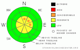
Danger Rose Tutorial
|
MODERATE Hazard of Avalanches in the La Sal Mountains at this time. High winds have transported snow to East NE and North facing slopes and will elevate the danger on these slopes above treeline. Inadequate cover for off trail travel in most areas.
CONSIDERABLE Hazard in the Abajo Mountains where much higher snow totals were measured. Expect 15 inches or more in the mountains around Monticello and a greatly increased avalacnhe danger there. |
|
|
CURRENT CONDITIONS |

|
Well it looks like we got about as much snow in Moab as we got up in the La Sals at this point but we have yet to go up on the hill and confirm. The SNOTEL site at 9800 ft is showing about 3" and we've had big winds out of the south and west. Overnight winds averaged in the 20-30's with gust up to 70 mph. It looks like wind will be the major player in our slightly increased avalanche hazard. This will not be the dump we need to cover the ground hazard out there and give us the green light for touring and riding off the roads. Don't expect that blower powder day yet. Disappointment is setting in, but the NWS is still calling for decent snow totoals for today, tonight and a continued chance of snow through the weekend. Best chance for powderhounding in SE Utah right now will be to head down the the old Blue Mountain Ski Resort outside of Monticello where they picked 15+ inches of new snow.
There is some grooming planned for later in the week, but we are waiting for the storms to abate so the groomer's efforts are not wasted.
We will update Road Conditions ASAP, but right now 4wd or Chains are recommended. |
|
|
RECENT ACTIVITY |

|
No observations |
|
|
THREAT #1 |

|
| WHERE |
PROBABILITY |
SIZE |
TREND |
|
|
|
|
| |
|
|
Over the next
72 hours.
|
|
|
Link to the U.S. Avalanche danger scale here: utahavalanchecenter.org/education/dangerscale
Expect to find a MODERATE avalanche Danger in the La Sal Mountains at this time on slopes approaching or steeper than 30 degrees. Hazard will be primarily limited to above treeline slopes where there is enough snow cover for snow slides to occur. Downwind slopes (East facing thru North Facing) will have an elevated hazard as a result of wind loading onto those aspects. On slopes at or below treeline hazard is limited by very lean snow coverage but be on the lookout for areas of deeper deposition, as these could release in small pockets due to our very weak underlying snowpack. We haven't had much snow, but drifted areas are tender and unstable so travel with care.
IN THE ABAJO MOUNTAINS EXPECT A HIGHER AVALACNHE HAZARD THAN IN THE LA SAL MOUNTAINS. INFORMATION IS LIMITED BUT 1.5 INCHES OF WATER (15" OR MORE SNOW) FELL AT THE CAMP JACKSON SNOTEL SITE AT 8600'. EXPECT TO FIND A CONSIDERABLE AVALANCHE DANGER IN THE MOUNTAINS AROUND MONTICELLO. RIDE WITH EXTREME CAUTION! |
|
|
MOUNTAIN WEATHER |

|
La Sal Mountain Weather for 10,000 ft:
Today: Snow and areas of blowing snow. High near 21. Southwest wind between 5 and 15 mph, with gusts as high as 35 mph. Chance of precipitation is 90%. Total daytime snow accumulation of 5 to 9 inches possible.
Tonight: Snow and areas of blowing snow. Low around 8. South southwest wind between 5 and 10 mph, with gusts as high as 30 mph. Chance of precipitation is 90%. New snow accumulation of 3 to 5 inches possible.
Wednesday: Snow likely and areas of blowing snow. Cloudy, with a high near 21. South wind around 5 mph, with gusts as high as 25 mph. Chance of precipitation is 70%. New snow accumulation of 3 to 5 inches possible.
Wednesday Night: Snow. Low around 12. Calm wind becoming southwest around 5 mph. Winds could gust as high as 25 mph. Chance of precipitation is 90%. New snow accumulation of 2 to 4 inches possible.
Thursday: Snow likely, mainly before 11am. Mostly cloudy, with a high near 22. Breezy, with a south southwest wind 5 to 10 mph increasing to between 20 and 25 mph. Winds could gust as high as 35 mph. Chance of precipitation is 70%.
Thursday Night: A 20 percent chance of snow. Mostly cloudy and breezy, with a low around 9.
Friday: A 20 percent chance of snow. Cloudy, with a high near 23.
Friday Night: A chance of snow. Cloudy, with a low around 8. |
|
|
GENERAL ANNOUNCEMENTS |
Our yearly AIARE level I avalanche course will be held this year from Friday, January 30th - Sunday February 1st. Proceeds from this class go directly to the Friends of La Sal Avalanche Center and help pay for the forecasting and education services provided by the Center. Please call Dave or Max 435-636-3363 to sign up for the class or get more information.
We will also be teaching some Avalanche Awareness seminars this winter. The first is scheduled for Monday, January 12th at 6:00 PM at the Grand County Library. These FREE seminars run about 2 hours and cover avalanche phenomena, basic travel techniques and self-rescue equipment overviews. They are a good opportunity to learn about the hazards of winter travel that winter recreationists face when traveling in the backcountry. Suitable for skiers, hikers, snow machiners, hunters and snowboarders. |
|
|
This information does not apply to developed ski areas or highways where avalanche control is normally done. This advisory is from the U.S.D.A. Forest Service, which is solely responsible for its content. This advisory describes general avalanche conditions and local variations always occur. |
|
This advisory provided by the USDA Forest Service, in partnership with:
The Friends of the Utah Avalanche Center, Utah Division of State Parks and Recreation, Utah Division of Emergency Management, Salt Lake County, Salt Lake Unified Fire Authority and the friends of the La Sal Avalanche Center. See our Sponsors Page for a complete list. |
