SPECIAL ANNOUNCEMENT |
 |
If you are looking for a meaningful gift for a loved one, consider giving an avalanche class... We offer several great learning opportunities in January in Logan including an Advanced Avalanche Skills Workshop on the 5th and 7th, and a Women's Backcountry 101 class on the 12th and 14th. Many other opportunities from across the state are listed on our Education Page. |
|
|
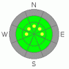
BOTTOM LINE
Danger by aspect and elevation on slopes approaching 35° or steeper.
(click HERE for tomorrow's danger rating)
|
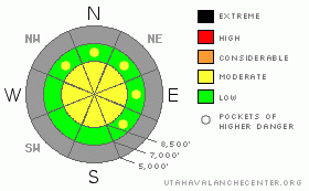
Danger Rose Tutorial
|
Today's windy storm will cause the danger to rise to level 2 or Moderate in drifted terrain. Increasing west and northwest winds accompanied by some snowfall will ramp up the danger throughout the day. By afternoon, you could trigger shallow fresh wind slab avalanches on steep drifted slopes. Also, if you venture into steep terrain, you are likely to trigger potentially long running, loose dry sluffs. Do not underestimate the risk of being swept into shallowly buried rocks or trees below. You should evaluate the snow and terrain carefully today, especially on drifted upper elevation slopes.... |
|
|
CURRENT CONDITIONS |

|
The Campbell Scientific Logan Peak weather station at 9700' reports 11 degrees and increasing winds from the west this morning. Overnight northwest winds at the station posted 30 mph averages for a few hours. The Tony Grove Snotel at 8400' reports 20 degrees, and there is 29 inches of total snow on the ground.. With 7 inches of water equivalent, the station sits at 64% of average for the date.. The snow cover is still just too thin for off track riding, and you will likely hit rocks if you venture into untracked snow anywhere but on the smoothest meadows. It is easy to bog down and become stuck in sugary, structureless snow.... We've found the best recrystallized "loud powder" conditions are on sheltered mid-elevation slopes. |
|
|
RECENT ACTIVITY |

|
No avalanches were reported recently in the Logan Zone. |
|
|
THREAT #1 |

|
| WHERE |
PROBABILITY |
SIZE |
TREND |

|
|
|
|
| |
|
|
Over the next
12 hours.
|
|
|
Even though not much snow is forecast, today's windy storm will cause an increase in avalanche danger in exposed or drifted terrain.. Freshly built wind slabs could be very sensitive, since drifts will build on very weak snow made up of feathery frost or surface hoar resembling corn flakes and sugary grains known as facets... Watch for wind drifted snow on the lee sides of ridges and subridges and in and around terrain features like gullies, scoops, and cliff bands... Even a fairly small avalanche could be quite dangerous if you are caught and carried over shallowly buried rocks below.... |
|
|
THREAT #2 |

|
| WHERE |
PROBABILITY |
SIZE |
TREND |
|
|
|
|
| |
|
|
Over the next
24 hours.
|
|
|
Generally manageable triggered loose dry sluffs involving weak sugary snow are again probable on very steep slopes today, so avoid terrain where you could be swept into gullies, rocks or trees below.. Be sure you are not above or below your partners or other parties, and keep an eye above as you descend. You might be surprised by the quantity of snow involved and the speed at which these sluffs can move especially on a steep and sustained slope.... |
|
|
MOUNTAIN WEATHER |

|
A cold storm will work its way southward over our area today, bringing windy conditions and a few inches of snow.... The initial band of light snowfall is passing over the Bear River range this morning, and west winds are gusting close to 40 mph on Logan Peak Expect snowfall to resume this afternoon and continue through the evening before the flow becomes easterly, which should shut down the snow tonight. 3 to 7 inches of accumulation is forecast. A ridge of high pressure will build back in overhead and persist through much of the holiday weekend. A weak storm may bring a little snow around Christmas Night.... |
|
|
GENERAL ANNOUNCEMENTS |
Please send us your observations from the backcountry especially if you see or trigger an avalanche, but also even if you don't.. go to avalanche and snow observations. You can also call me directly at 435-757-7578 or leave us a message at our office, 801-524-5304.... And, you can always send us a simple email by clicking HERE
Special message from our partners, the Friends of Utah Avalanche Center: This is a tense time for us. The recession is making it harder to pay for avalanche forecasting in Utah. Many of you have already donated and we deeply appreciate that. Sending in checks, donating online, and coming to the Fall Black Diamond Party or our Pray for Snow fundraiser in Logan– it all helps. As 2011 comes to an end, please consider what daily avalanche information means to your knowledge of what is going on in the mountains, what elevations and aspects are likely to provide best safety and riding conditions, and your understanding of how to avoid avalanches. If this is critical to your life in the mountains, please consider an additional donation and pester your partners - are they stepping up and donating as well? With your help, we can keep this program strong and growing. To donate, go to http://utahavalanchecenter.org/donate Have a great holiday season and stay safe.
I will update this advisory by around 7:30 in the morning on Mondays, Wednesdays, Fridays, and Saturdays.....
This advisory is from the U.S.D.A. Forest Service, which is solely responsible for its content. This advisory describes general avalanche conditions and local variations always occur. |
|
|
This information does not apply to developed ski areas or highways where avalanche control is normally done. This advisory is from the U.S.D.A. Forest Service, which is solely responsible for its content. This advisory describes general avalanche conditions and local variations always occur. |
|
This advisory provided by the USDA Forest Service, in partnership with:
The Friends of the Utah Avalanche Center, Utah Division of State Parks and Recreation, Utah Division of Emergency Management, Salt Lake County, Salt Lake Unified Fire Authority and the friends of the La Sal Avalanche Center. See our Sponsors Page for a complete list. |
